Gosford
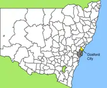
Gosford is a suburb of the Central Coast Council local government area in the heart of the Central Coast region, about 76 kilometres (47 mi) north of Sydney. The suburb is situated at the northern extremity of Brisbane Water, an extensive northern branch of the Hawkesbury River estuary and Broken Bay.
| Kibble Park Town Central Coast Council Mayor: Isabelle Allsopp, New South Wales | |||||||||||||||
|---|---|---|---|---|---|---|---|---|---|---|---|---|---|---|---|
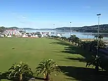
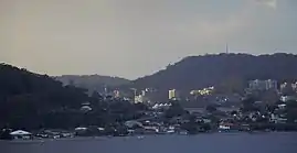 Gosford skyline | |||||||||||||||
| Population |
| ||||||||||||||
| Postcode(s) | 2250 | ||||||||||||||
| Elevation | 20 m (66 ft) | ||||||||||||||
| Time zone | AEST (UTC+10) | ||||||||||||||
| • Summer (DST) | AEST (UTC+11) | ||||||||||||||
| Location | 76 km (47 mi) from Sydney | ||||||||||||||
| LGA(s) | Central Coast Council | ||||||||||||||
| County | Northumberland | ||||||||||||||
| State electorate(s) | Gosford | ||||||||||||||
| Federal Division(s) | Robertson | ||||||||||||||
| |||||||||||||||
| |||||||||||||||
The suburb is the administrative centre and CBD of the Central Coast region, which is the third largest urban area in New South Wales after Sydney and Newcastle. Following its formation from the combination of the previous Gosford City and Wyong Shire Councils, Gosford has been earmarked as a vital CBD spine under the NSW Metropolitan Strategy.[3] The population of the Gosford area was 169,053 in 2016.[2]
History
Until white settlement, the area around Gosford was inhabited by the Guringai peoples, who were principally coastal-dwellers,[4] and the Darkinjung people that inhabited the hinterland. Along with the other land around the Hawkesbury River estuary, the Brisbane Water district was explored during the early stages of the settlement of New South Wales.
Gosford itself was explored by Governor Phillip between 1788 and 1789.[5] The area was difficult to access and settlement began around 1823. By the late 19th century the agriculture in the region was diversifying, with market gardens and citrus orchards occupying the rich soil left after the timber harvest. As late as 1850, the road between Hawkesbury (near Pittwater) and Brisbane Water was a cart wheel track.[6]
Typical of early Colonial settlement, convicts lived and worked in the Gosford area. In 1825, Gosford's population reached 100, of whom 50% were convicts.
East Gosford was the first centre of settlement. Gosford was named in 1839 after Archibald Acheson, 2nd Earl of Gosford – a friend of the then Governor of New South Wales George Gipps.[7] Acheson's title derives its name from Gosford, a townland (sub-division) of Markethill in County Armagh in Northern Ireland.
In 1887, the rail link to Sydney was completed, requiring a bridge over the Hawkesbury River and a tunnel through the sandstone ridge west of Woy Woy. The introduction of this transport link and then the Pacific Highway in 1930 accelerated the development of the region.
Gosford became a town in 1885 and was declared a municipality in 1886.[8]
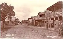
.jpg.webp)
Demographics
At the 2016 census, there were 3,499 people in Gosford. 59.6% of people were born in Australia. The next most common countries of birth were India 4.5%, and England 2.9%. 65.2% of people spoke only English at home. Other languages spoken at home included Mandarin at 3.7%. The most common responses for religion were No Religion 33.9% and Catholic 18.2%.[1]
Geography
Climate
Gosford has a humid subtropical climate (Köppen climate classification: Cfa)[9] with warm summers and mild winters. In summer, temperatures average about 27–28 °C in the day with high humidity and about 17–18 °C at night. Winters are mild with cool overnight temperatures and mild to occasionally warm daytime temperatures with lower humidity. Average rainfall is 1333mm, much of which falls in the late summer and autumn. Records range from a maximum of 44.8 °C (113 °F) on 18 January 2013, to a low of −4.2 °C (24 °F) on 16 July 1970.
| Climate data for Gosford | |||||||||||||
|---|---|---|---|---|---|---|---|---|---|---|---|---|---|
| Month | Jan | Feb | Mar | Apr | May | Jun | Jul | Aug | Sep | Oct | Nov | Dec | Year |
| Record high °C (°F) | 44.8 (112.6) |
43.0 (109.4) |
40.1 (104.2) |
32.9 (91.2) |
28.8 (83.8) |
25.0 (77.0) |
25.5 (77.9) |
29.9 (85.8) |
36.1 (97.0) |
38.0 (100.4) |
41.8 (107.2) |
43.0 (109.4) |
44.8 (112.6) |
| Average high °C (°F) | 28.2 (82.8) |
27.4 (81.3) |
26.0 (78.8) |
23.4 (74.1) |
20.6 (69.1) |
18.4 (65.1) |
17.7 (63.9) |
19.4 (66.9) |
22.2 (72.0) |
24.0 (75.2) |
25.0 (77.0) |
26.9 (80.4) |
23.3 (73.9) |
| Average low °C (°F) | 17.2 (63.0) |
17.2 (63.0) |
15.4 (59.7) |
12.1 (53.8) |
8.8 (47.8) |
6.7 (44.1) |
5.4 (41.7) |
5.6 (42.1) |
8.3 (46.9) |
10.9 (51.6) |
13.7 (56.7) |
15.7 (60.3) |
11.4 (52.5) |
| Record low °C (°F) | 7.5 (45.5) |
9.7 (49.5) |
5.8 (42.4) |
1.5 (34.7) |
0.1 (32.2) |
−1.5 (29.3) |
−4.2 (24.4) |
−1.1 (30.0) |
−0.6 (30.9) |
1.1 (34.0) |
3.9 (39.0) |
6.0 (42.8) |
−4.2 (24.4) |
| Average precipitation mm (inches) | 115.6 (4.55) |
185.6 (7.31) |
140.2 (5.52) |
154.6 (6.09) |
119.7 (4.71) |
113.6 (4.47) |
74.3 (2.93) |
72.8 (2.87) |
64.8 (2.55) |
90.8 (3.57) |
95.5 (3.76) |
109.2 (4.30) |
1,333 (52.48) |
| Average precipitation days | 11.3 | 11.1 | 11.5 | 11.4 | 10.5 | 10.4 | 9.3 | 8.4 | 8.5 | 9.4 | 10.1 | 10.1 | 122.0 |
| Average afternoon relative humidity (%) | 59 | 63 | 62 | 61 | 61 | 62 | 55 | 48 | 51 | 54 | 59 | 59 | 58 |
| Source: [10] | |||||||||||||
Central Business District
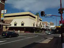
Gosford proper is located in a valley with President's Hill on the city's western border, Rumbalara Reserve on its eastern border, and Brisbane Water to the city's south. Mann Street, Gosford's main street and part of the Pacific Highway, runs north-south and contains the frontage for much of the commercial district.
In the centre of Gosford is a shopping and community precinct, including Kibble Park, William Street Mall, Gosford City Library, the Imperial Shopping Centre and a full range of shops, cafes, banks and services.
A renewed period of optimism has followed demolition of several derelict buildings and several infrastructure investment projects including the full fibre optic telecommunications rollout of the National Broadband Network in 2012 in the city's CBD[11] as well as the so-called Kibbleplex project, announced in 2013[12] that plans to house the new regional library, tertiary teaching rooms and associated organisations.

Recent residential apartments have been built in various areas of the Gosford Central Business District.
Economy and infrastructure
Gosford is situated along an identified business growth corridor between Erina, the West Gosford light industrial zone and Somersby. Connectivity of main roads and rail travel times between Sydney, the Central Coast, Lake Macquarie and the city of Newcastle are key issues for corporate business relocation to the region. Aged and personal care and retail are major employers in Gosford. [13]
As an entertainment hub, Mann Street enjoys relatively good public transport links and is one of the Central Coast's most popular spots for pubs and clubs and in close proximity to cultural and sporting events.
Yacht and other boat building has been undertaken by East Coast Yachts[14] since 1964[15] in West Gosford.
Facilities
Gosford is home to:
- Gosford Hospital – the largest hospital on the NSW Central Coast
- Laycock Street Community Theatre – the only professional, proscenium arch theatre venue on the Central Coast. Home of Gosford Musical Society who in fact provided financial support in the construction of the theater.
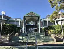
- The Central Coast Conservatorium (in the original Gosford Courthouse)
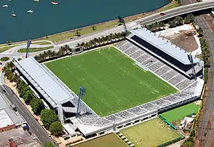
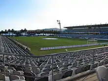
- Central Coast Stadium in Grahame Park, adjacent to the Central Coast Leagues Club. Originally built for the Central Coast Bears team in the NRL rugby league competition (to this day, the seats are arranged to say 'Go Bears'), since 2005 it is the home of the successful Central Coast Mariners A-League soccer / association football team and was the home venue of the Central Coast Rays rugby union Australian Rugby Championship team.
- Central Coast Leagues Club – is the largest community sporting and social club in the region
- The Entertainment Grounds, formerly known as Gosford Racecourse
- Gosford Showground
- The headquarters of the Government of New South Wales workplace health and safety regulator, SafeWork NSW[16]
- Gavenlock Oval – Home ground of the Gosford City Dragons
- Gosford Regional Gallery and Gosford/Edogawa Commemorative Garden – The Commemorative Garden is a Japanese garden that was built as a gift to residents of Gosford City Council by the Ward of Edogawa, Tokyo, Japan. They were opened in September 1994.
Media
Gosford Community News has been published fortnightly by Ducks Crossing Publications since 2010.
Express Advocate: News Limited publish a free weekly suburban style newspaper in the News Local group.
Radio stations available:
- 2GO – part of Southern Cross Austereo
- Sea FM
- ABC 92.5
- CoastFM 96.3
- StarFM 104.5
- EVT FM – Chinese radio network
Transport
The Central Coast Highway cuts through Gosford's waterfront area, while its predecessor the, Pacific Highway, takes on several names through the CBD itself.
Mann Street contains the main public transport links for Gosford, including Gosford railway station, with trains twice an hour to Sydney Central Station and to Newcastle Interchange.
There is also a terminal for several bus routes linking Gosford to the rest of the Central Coast outside of Gosford station.
Education
- Gosford Public School and Henry Kendall High School in Faunce Street
- Gosford High School - the only academically selective high school on the Central Coast
- St Philip's Christian College Gosford
- St Joseph's Catholic College, East Gosford is an all girls Catholic school
- St Edward's College, East Gosford - is an all boys Catholic school
- Hunter Institute of TAFE
Notable people
- Craig Anderson – pitcher for Sydney Blue Sox of the Australian Baseball League
- Estelle Asmodelle – former model, dancer, and activist. Currently, musician, abstract artist and academic. She is known as Australia's first legal transsexual
- Cindy-Lu Bailey – deaf former Olympic athlete
- Bradman Best – professional Rugby League player for Newcastle Knights
- Charlotte Best – actress, known for her role as Annie Campbell on Home and Away
- Anthony Biddle – Paralympian tandem cyclist and athlete[17]
- Alan Davidson – former Australian cricketer
- Grant Denyer – Australian television and radio presenter
- Mark Edmondson – former tennis professional and winner of the 1976 Australian Tennis Open
- David Fairleigh – former Rugby League forward, current coach of the Central Coast Bears
- James Gleeson – one of Australia's earliest and most recognised surrealist painters, also a poet and art critic. His family lived in Narara and in the 1920s, Gosford and they owned the Gosford pub. The coolroom of the Gosford pub occasionally served as an impromptu city morgue
- Des Hasler – former professional rugby league footballer, current coach of Manly Warringah Sea Eagles
- Allyson McConnell – convicted killer who drowned her two children in Alberta, Canada[18]
- Matt Orford – former NRL halfback
- Chris Payne – footballer playing for the North Queensland Fury in the A-League
- Ron Peno – Australian Punk & 1980's Rock musician; Lead Singer of Died Pretty
- Brad Porter – retired Football Midfielder
- Andrew Redmayne – goalkeeper for Sydney FC
- Sam Retford – actor, known for his role as Cory Wilson on Ackley Bridge[19]
- Mark Skaife – 5-time Supercars champion and 6-time Bathurst 1000 winner
- Matthew Zions – European PGA professional golfer (2003–present), 2011 Saint-Omer Open winner
See also
References
- Australian Bureau of Statistics (27 June 2017). "Gosford (State Suburb)". 2016 Census QuickStats. Retrieved 18 March 2018.

- Australian Bureau of Statistics (27 June 2017). "Gosford (SA3)". 2016 Census QuickStats. Retrieved 6 October 2020.
- "Cities Taskforce". NSW Government Planning & Infrastructure. Retrieved 11 May 2013.
- Gosford – Central Coast
- Coasting : a year by the bay. Sceptre. March 2012. ISBN 9780733610189. Retrieved 23 March 2020.
- History of Gosford
- "Some Significant events in Gosford History". Archived from the original on 24 June 2014. Retrieved 29 June 2014.
- "Gosford – Central Coast Australia". Centralcoastaustralia.com.au. Retrieved 24 April 2012.
- CLIMATE: GOSFORD
- "Climate statistics for Australian locations". Retrieved 1 October 2017.
- NBN services go live in Gosford
- Gosford funding
- "Industry sector of employment | Central Coast NSW | Community profile". profile.id.com.au. Retrieved 26 October 2020.
- "East Coast Yachts". Sailing Networks. Archived from the original on 4 April 2017. Retrieved 3 April 2017.
- "Bruce Fairlie". Unsung Business Heroes. Retrieved 3 April 2017.
- OFFICE LOCATIONS
- "Australians at the 1996 Atlanta Paralympics: Athletes". Australian Sports Commission. Archived from the original on 20 January 2000. Retrieved 4 February 2012.
- Boys found dead were at centre of custody fight
- "Sam Retford talks to Northern Soul about time travel, typecasting and telly". Retrieved 20 November 2018.