Wisemans Ferry, New South Wales
Wisemans Ferry is a town in the state of New South Wales, Australia, located 75 kilometres north north-west of the Sydney central business district in the local government areas of Hornsby Shire, The Hills Shire, City of Hawkesbury and Central Coast Council. The town is a tourist spot with picnic and barbecue facilities. As well as a rich convict and colonial heritage in the area, the Dharug National Park and Yengo National Park are close by.
| Wisemans Ferry New South Wales | |||||||||||||||
|---|---|---|---|---|---|---|---|---|---|---|---|---|---|---|---|
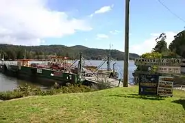 The ferry over the Hawkesbury River | |||||||||||||||
Wisemans Ferry | |||||||||||||||
| Coordinates | 33°22′55″S 150°59′06″E | ||||||||||||||
| Established | 1827 | ||||||||||||||
| Postcode(s) | 2775 | ||||||||||||||
| Location | |||||||||||||||
| LGA(s) | |||||||||||||||
| Parish | Cornelia, Frederick | ||||||||||||||
| State electorate(s) | Gosford, Hawkesbury | ||||||||||||||
| Federal Division(s) | Berowra, Macquarie, Robertson | ||||||||||||||
| |||||||||||||||
History
The town was originally called Lower Portland Headland, but the name was eventually changed to Wisemans Ferry, named after Solomon Wiseman, a former convict (1778–1838), who received a land grant in the area from Governor Macquarie in 1817.[1] Wiseman established a ferry service on the Hawkesbury River in 1827 for the transport of produce and provisions to the convicts building the Great North Road and was known to many as King of the Hawkesbury.[2]
Wisemans Ferry Post Office opened on 1 January 1857.[3]
There is information on the early history of Wisemans Ferry in Ball, John and Pam, 'Early Wisemans Ferry: George Mollison, Solomon Wiseman, Bushrangers and Land Title Confusion', Oughtershaw Press, Riverview, 2014 - ISBN 978 0 9593420 9 3.
Heritage listings
Wisemans Ferry & Mount Manning has a number of heritage-listed sites, including:
Schools
Wisemans Ferry Public School was established in 1867.
Transport
Today, two ferry services cross the Hawkesbury River from the town of Wisemans Ferry. The eponymous Wisemans Ferry crosses the river to a point down-stream of its confluence with the Macdonald River, connecting with the old Great North Road. Webbs Creek Ferry crosses to a point upstream of the confluence, connecting with the St Albans Road that follows the west bank of the Macdonald River.[5]
References
- "Wisemans Ferry". The Sydney Morning Herald. 8 February 2004. Retrieved 17 September 2007.
- Reed, A.W. (1969) Place-Names of New South Wales: Their Origins and Meanings, p. 151. Sydney: A.H & A.W. Reed
- Premier Postal History. "Post Office List". Premier Postal Auctions. Retrieved 13 January 2021.
- "Old Great North Road, Between Devine's Hill and Mount Manning". New South Wales State Heritage Register. Office of Environment and Heritage. H00991. Retrieved 18 May 2018.
- "Vehicle ferries". New South Wales Roads and Maritime Services. Retrieved 1 May 2017.
External links
| Wikivoyage has a travel guide for Wisemans Ferry. |
- Joan Rowland (2008). "Wisemans Ferry". Dictionary of Sydney.
- Great North Road - Convict Trail
- Wisemans Ferry bus timetable
Hawkesbury River region, New South Wales, Australia | |||||||||
|---|---|---|---|---|---|---|---|---|---|
| Islands | |||||||||
| National parks and nature reserves | |||||||||
| European explorers of the region | |||||||||
| Bridges and ferries |
| ||||||||
| Adjoining rivers, bays, reservoirs, and creeks |
| ||||||||
| Local government areas | |||||||||
| Education |
| ||||||||
| Major attractions | |||||||||
| |||||||||
| Authority control |
|
|---|