Mount Matier
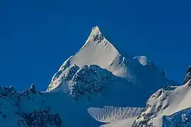
Mount Matier is a prominent 2,783-metre (9,131-foot) mountain summit located in the Coast Mountains, in Joffre Lakes Provincial Park, in southwestern British Columbia, Canada. It is the highest point of the Joffre Group, which is a subset range of the Coast Mountains.[3] It is situated 26 km (16 mi) east of Pemberton, and 9 km (6 mi) northeast of Lillooet Lake. Its nearest higher peak is Mount Weart, 30 km (19 mi) to the southwest.[3] The slopes of the mountain are covered by the Matier Glacier on the northwest, Anniversary Glacier on the northeast, Twin One Glacier on the southeast, and Hartzell Glacier to the south. Precipitation runoff from the peak drains into Joffre Creek and Twin One Creek, both tributaries of the Lillooet River. The first ascent of the mountain was made on August 18, 1957, by Dick Chambers, Joe Hutton, Roy Mason, Paddy Sherman, and Cyril Scott, who were members of the British Columbia Mountaineering Club.[1] The mountain's name honors Tom Matier, an early well-known prospector in the area.[4] Its name was officially adopted on April 21, 1966, by the Geographical Names Board of Canada.[2]
| Mount Matier | |
|---|---|
 Mount Matier | |
| Highest point | |
| Elevation | 2,783 m (9,131 ft) [1] |
| Prominence | 1,241 m (4,072 ft) [1] |
| Parent peak | Skihist Mountain (2968 m)[1] |
| Coordinates | 50°19′35″N 122°26′37″W [2] |
| Geography | |
 Mount Matier Location in British Columbia  Mount Matier Mount Matier (Canada) | |
| Location | Joffre Lakes Provincial Park British Columbia, Canada |
| Parent range | Joffre Group Coast Ranges |
| Topo map | NTS 92J/8 |
| Climbing | |
| First ascent | 1957 |
| Easiest route | Scrambling, glacier travel |
Climate

Based on the Köppen climate classification, Mount Matier is located in a subarctic climate zone of western North America.[5] Most weather fronts originate in the Pacific Ocean, and travel east toward the Coast Mountains where they are forced upward by the range (Orographic lift), causing them to drop their moisture in the form of rain or snowfall. As a result, the Coast Mountains experience high precipitation, especially during the winter months in the form of snowfall. Temperatures can drop below −20 °C with wind chill factors below −30 °C. The months July through September offer the most favorable weather for climbing Matier.
.jpg.webp)
Climbing Routes
Established climbing routes on Mount Matier:[1]
References
- "Mount Matier". Bivouac.com. Retrieved 2019-11-08.
- "Mount Matier". Geographical Names Data Base. Natural Resources Canada. Retrieved 2019-11-08.
- "Mount Matier, British Columbia". Peakbagger.com. Retrieved 2019-11-08.
- "Mount Matier". BC Geographical Names.
- Peel, M. C.; Finlayson, B. L.; McMahon, T. A. (2007). "Updated world map of the Köppen−Geiger climate classification". Hydrol. Earth Syst. Sci. 11. ISSN 1027-5606.
External links
- Climbing Matier in winter: YouTube
- Mt. Matier weather: Mountain Forecast
- Flickr photo: Mt. Matier featuring Twin One Glacier
