Joffre Peak
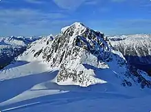
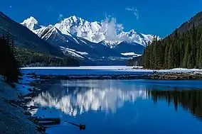
Joffre Peak is a 2,721-metre (8,927-foot) mountain summit located in the Coast Mountains, in Joffre Lakes Provincial Park, in southwestern British Columbia, Canada. It is the second-highest point of the Joffre Group, which is a subset of the Lillooet Ranges.[3] It is situated 26 km (16 mi) east of Pemberton, and 11 km (7 mi) northeast of Lillooet Lake. Its nearest higher peak is Mount Matier, 1.6 km (1 mi) to the south.[3] The mountain supports the Matier Glacier on the southwest slope, and the Anniversary Glacier on the southeast slope. Precipitation runoff from the peak drains into Joffre Creek and Cayoosh Creek. The first ascent of the mountain was made on July 19, 1957 by Dick Chambers and Paddy Sherman, who were members of the British Columbia Mountaineering Club.[1] The first ascent party named this peak for its position at the head of Joffre Creek. The mountain's name honors Marshal Joseph Jacques Césaire Joffre (1852–1931), a French general who served as Commander-in-Chief of French Armies in World War I.[4] The name was officially adopted on June 22, 1967, by the Geographical Names Board of Canada.[2] Joffre Peak should not be confused with Mount Joffre in the Canadian Rockies which is also named for the same person.
| Joffre Peak | |
|---|---|
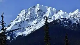 Joffre Peak, northeast aspect | |
| Highest point | |
| Elevation | 2,721 m (8,927 ft) [1] |
| Prominence | 331 m (1,086 ft) [1] |
| Parent peak | Mount Matier (2783 m)[1] |
| Coordinates | 50°20′28″N 122°26′44″W [2] |
| Geography | |
 Joffre Peak Location in British Columbia  Joffre Peak Joffre Peak (Canada) | |
| Location | Joffre Lakes Provincial Park British Columbia, Canada |
| Parent range | Joffre Group Lillooet Ranges Coast Ranges |
| Topo map | NTS 92J/8 |
| Climbing | |
| First ascent | 1957 R. Chambers, P. Sherman |
| Easiest route | Scrambling, glacier travel |
Climate
Based on the Köppen climate classification, Joffre Peak is located in a subarctic climate zone of western North America.[5] Most weather fronts originate in the Pacific Ocean, and travel east toward the Coast Mountains where they are forced upward by the range (Orographic lift), causing them to drop their moisture in the form of rain or snowfall. As a result, the Coast Mountains experience high precipitation, especially during the winter months in the form of snowfall. Temperatures can drop below −20 °C with wind chill factors below −30 °C. The months July through September offer the most favorable weather for climbing Joffre Peak.
Climbing Routes
Established climbing routes on Joffre Peak:[1]
References
- "Joffre Peak". Bivouac.com. Retrieved 2019-11-08.
- "Joffre Peak". Geographical Names Data Base. Natural Resources Canada. Retrieved 2019-11-08.
- "Joffre Peak, British Columbia". Peakbagger.com. Retrieved 2019-11-08.
- "Joffre Peak". BC Geographical Names.
- Peel, M. C.; Finlayson, B. L.; McMahon, T. A. (2007). "Updated world map of the Köppen−Geiger climate classification". Hydrol. Earth Syst. Sci. 11. ISSN 1027-5606.
See also

External links
- Climbing Joffre Peak: YouTube
- Weather: Joffre Peak
- 2019 Landslides: CBC News