Murray Morgan Bridge
The Murray Morgan Bridge, also known as the 11th Street Bridge or City Waterway Bridge, is a vertical-lift bridge in Tacoma, Washington. It originally opened Feb. 15, 1913 to replace an 1894 swing-span bridge.[2] The bridge connects downtown with the tideflats, it spans the Thea Foss Waterway, originally known as the City Waterway. Designed by noted bridge engineering firm Waddell & Harrington, the bridge has some unusual features: higher above the water than most lift bridges, construction on a variable grade and an overhead span designed to carry a water pipe.[3] The bridge structure also contained a series of switchback ramps that connected what is now Cliff Street with Dock Street. According to the Department of Transportation, the towers are 207' 13⁄4" (63.14 m) above the water, with the road deck 60' above the water level at zero tide. It was modified and updated in 1957 and was used to route State Route 509 through the tideflats. The bridge was bypassed in the late 1990s when State Route 509 was routed around the edge of the tideflats (see East 21st Street Bridge). While WSDOT wanted to tear down the bridge, the City of Tacoma convinced the state to transfer ownership to the City.[4] In the past, the bridge has been heavily used by commuters and emergency services in connecting the Port of Tacoma with downtown Tacoma.[5][6]
City Waterway Bridge | |
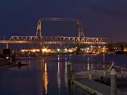 Murray Morgan Bridge from the Thea Foss Waterway | |
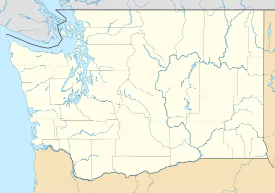 | |
| Location | Tacoma, Washington |
|---|---|
| Coordinates | 47°15′14.45″N 122°25′56.57″W |
| Built | 1911 |
| Architect | Waddell & Harrington; International Contract Co. |
| MPS | Historic Bridges/Tunnels in Washington State TR |
| NRHP reference No. | 82004278[1] |
| Added to NRHP | July 16, 1982 |
In 2007, the bridge was closed because of safety concerns and the general wear and tear that the bridge had suffered in its near 100-year lifespan. Soon afterwards, the city began a large rehabilitation project to completely overhaul all aspects of the bridge. In 2010, the bridge began periodically opening to bikes and pedestrians.[7] In February 2013, the bridge re-opened to all traffic.[8]
Name
Originally known as the 11th Street Bridge, it was renamed May 21, 1997, to honor Tacoma-born Murray Morgan (1916–2000), the best-known Pacific Northwest historian of his generation, and author of "Skid Road", a history of Seattle, Washington. Morgan was a bridge tender on the bridge during the 1950s. In fact, he wrote most of "Skid Road" during quiet periods on the job.[9][10]
Closure
The bridge was officially closed to vehicles on October 23, 2007, due to "life safety concerns".[11][12] The bridge re-opened February 2013 after a large rehabilitation project.[8]
Opening
On February 1, 2013, the bridge re-opened after a large rehabilitation project was completely finished. Down from four lanes to two, the bridge is now solid black (its original color) and features antique-esque lighting (actually LED bulbs) to celebrate the bridge's centennial anniversary. The outer two lanes were converted to larger pedestrian paths and bike lanes. An elevator connects pedestrians and bikes to Dock Street below the bridge. The bridge's environmental impact has been lessened; a new water runoff system routes rainwater to tanks that contribute to a rain garden on the east side of the bridge. The computers, cables, and motors that operate the lift in the center of the structure were also updated.[8]
Damage
On December 15, 2010 it was discovered that thieves had broken into the mechanical room and stolen wiring from the control panel used to raise the bridge for ship traffic on the Foss Waterway. As part of the rehabilitation project, the computers and electrics in the bridge were replaced.[8]
References
- "National Register Information System". National Register of Historic Places. National Park Service. January 23, 2007.
- Long, Priscilla (2003-09-06). "the Free Online Encyclopedia of Washington State History". HistoryLink.org. Retrieved 2011-08-20.
- "WSDOT: City Waterway Bridge". Wsdot.wa.gov. 2006-05-18. Retrieved 2011-08-20.
- Santos, Melissa (November 12, 2007). "Broken promises on bridge". The News Tribune. Tacoma, Washington. Archived from the original on September 13, 2012. Retrieved August 15, 2012.
- "Murray Morgan Bridge Frequently Asked Questions". City of Tacoma. Archived from the original on September 7, 2012. Retrieved August 15, 2012.
- Larson, John (30 March 2010). "Murray Morgan Bridge opens for pedestrians". Tacoma, Washington. Archived from the original on 2015-09-24. Retrieved 2 February 2013.
- Gillie, John (1 February 2013). "Tacoma's Murray Morgan Bridge reopening". The News Tribune. Tacoma, Washington. Archived from the original on 4 February 2013. Retrieved 2 February 2013.
- Long, Priscilla (2003-05-16). "the Free Online Encyclopedia of Washington State History". HistoryLink.org. Retrieved 2011-08-20.
- Lange, Greg (2002-11-29). "the Free Online Encyclopedia of Washington State History". HistoryLink.org. Retrieved 2011-08-20.
- Hagey, Jason (October 24, 2007). "Murray Morgan closed". The News Tribune. Archived from the original on February 4, 2013. Retrieved August 15, 2012.
- Safety Concerns Close Murray Morgan Bridge WSDOT Press Release
External links
| Wikimedia Commons has media related to 11th Street Bridge, Tacoma, Washington. |
- Historylink - Tacoma's Eleventh Street (City Waterway) Bridge opens on February 15, 1913.
- Historylink - Washington renames Tacoma's Eleventh Street Bridge as Murray Morgan Bridge on May 21, 1997.
- Puget Sound Transportation Projects - Murray Morgan Bridge
Map Coordinates: 47.253995°N 122.43327°W
| Topics | |
|---|---|
| Lists by state |
|
| Lists by insular areas | |
| Lists by associated state | |
| Other areas | |
| Related | |
| |