Nabarangpur district
Nabarangpur district, also known as Nabarangapur district and Nawarangpur district, is a district of Odisha, India. The city of Nabarangpur is the district capital. Most of its population is tribal and the land is heavily forested. It borders the Kalahandi and Koraput districts. Nabarangpur district is situated at 19.14′ latitude and 82.32′ longitude at an average elevation of 1,876 feet (572 m).
Nabarangpur district | |
|---|---|
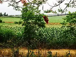 Nabarangpur countryside | |
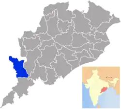 Location in Odisha, India | |
| Coordinates: 19.23°N 82.55°E | |
| Country | |
| State | |
| Headquarters | Nabarangpur |
| Government | |
| • Collector & District Magistrate | Ajit Kumar Mishra, OAS (SAG) |
| • Divisional Forest Officer Cum Wildlife Warden | K.R Parida, [OFS-1] |
| • Superintendent of Police | Vivekananda Sharma, IPS |
| Area | |
| • Total | 5,294 km2 (2,044 sq mi) |
| Elevation | 195 m (640 ft) |
| Population (2011) | |
| • Total | 1,220,946 |
| • Density | 192/km2 (500/sq mi) |
| Languages | |
| • Official | Odia, English |
| • Other Local Language | Bhatri, Gondi, Kui |
| Time zone | UTC+5:30 (IST) |
| PIN | 764 059 |
| Vehicle registration | OD-24 |
| Sex ratio | 1.007 ♂/♀ |
| Lok Sabha constituency | Nabarangpur(ST) |
| Vidhan Sabha constituency | 4
|
| Climate | Aw (Köppen) |
| Precipitation | 1,691 millimetres (66.6 in) |
| Avg. summer temperature | 40 °C (104 °F) |
| Avg. winter temperature | 12 °C (54 °F) |
| Website | www |
| This article is part of a series on |
| Odisha |
|---|
 |
| Governance |
|
| Topics |
|
Districts Divisions |
| GI Products |
|
|
History
Early history for the region is scanty. The Mauryas were believed to have exercised some control over the region, which was under the control of Kalinga. Kharevala, who led a Kalinga resurgence, mentioned the territory as Vidyadhara and used troops for the region in his conquests. The second and third centuries saw Nabarangpur ruled by the Satavahanas, Ikshavakus and Vakatakas in succession. However by 350 CE the district was not under the control of any major power, when Samudragupta led an expedition to the region. However Nabarangpur never came under direct control of the Guptas. In the 4th or 5th century CE the Nala dynasty, with their headquarters in Pushkari near Umerkote, took control of the entire Bastar-Koraput region. The ruins of large temples and land grants indicate extensive civilizational development in the area. The Nalas fought several wars with the Vakatakas, the first of which they won handily and the second of which Pushkari was destroyed. Nala power was briefly restored by Skanda Varman, who rebuilt Pushkari, but was soon swept away by the Chalukyas. At the end of the 5th century CE, the Eastern Gangas came to control the area, but this period is little-known.[1]
By the middle of the 9th century CE, the territory, known as Trikalinga, was now under the Somvanshi rulers of South Kosala. In 1023, Rajendra Chola conquered the entire Bastar-Koraput region, then known as Chakrakota, but was soon beaten back by the Gangas.
At this time the Chindaka Naga dyansty, attested to in the Errakote inscription, established its rule in the region starting in 945. The Telugu Chodas, who accompanied Vikramaditya VI's expedition to the region, became feudatories to them. Although the dynasty lost strength starting in 1050, descendants of the family continued to rule until the 13th century. They were replaced by the Matsyas, who may have exercised some control over Nabarangpur. In the 14th century, the Silavamshis conquered the region and patronized Jainism and Shaktism.
The modern district of Nabarangpur was under the territory of the Suryavanshi kings of Jeypore, who were previously feudatories of the Gajapatis starting in the 15 century CE until the dissolution of the princely state in 1951. When the Gajapatis collapsed in 1541 following the death of Prataparudra Deva, Vishwanath Dev, ruler of Nandapur and a former feudal lord of Pratap Rudra conquered a large territory that touched Bengal in the north to river Godavari in the south and stretched up to Visakhapatanam in the east till the kingdom of Bastar in the west.[2]
Later, Vikram Dev I (1758-1781 CE) of Jeypore appointed his second son Jagganath Dev as the zamindar of Nowrangpur.[3] The district was thus administered as a part of Koraput. Eventually Nabarangpur subdivision was created in 1941 and in 1991, Nabarangpur district was split off.
Economy
In 2006, the Ministry of Panchayati Raj named Nabarangpur one of the country's 250 poorest districts (out of a total of 640).[4] It is one of the 19 districts in Odisha currently receiving funds from the Backward Regions Grant Fund Programme (BRGF).[4]
Demographics
According to the 2011 Census of India Nabarangpur district has a population of 1,220,946, ranking it the 390th in population (out of a total of 640).[5] The district has a population density of 230 inhabitants per square kilometre (600/sq mi).[5] Its population growth rate over the decade 2001-2011 was 18.81%.[5] Nabarangapur has a sex ratio of 1018 females for every 1000 males[5] and a literacy rate of 48.2%. Scheduled Castes are 14.5% of the population while Scheduled Tribes are 55.8%.[5]
At the time of the 2011 census, 71.13% of the population in the district spoke Odia, 7.12% Bhatri, 4.50% Gondi, 4.41% Bengali, 4.28% Chhattisgarhi, 1.90% Halbi, 1.57% Kui and 1.40% Kuvi as their first language.[6] Major Odia dialects of the region include Desiya Odia.
| Year | Pop. | ±% p.a. |
|---|---|---|
| 1901 | 180,597 | — |
| 1911 | 217,118 | +1.86% |
| 1921 | 210,348 | −0.32% |
| 1931 | 248,072 | +1.66% |
| 1941 | 294,084 | +1.72% |
| 1951 | 330,476 | +1.17% |
| 1961 | 422,325 | +2.48% |
| 1971 | 547,944 | +2.64% |
| 1981 | 681,579 | +2.21% |
| 1991 | 846,659 | +2.19% |
| 2001 | 1,025,766 | +1.94% |
| 2011 | 1,220,946 | +1.76% |
| Source:[7] | ||
Languages of Nabarangpur district in 2011 census
Vidhan sabha constituencies
The following are the four Vidhan sabha constituencies of Nabarangpur district and the elected members[8] of that area:
| No. | Constituency | Reservation* | Extent of the Assembly Constituency (Blocks) | Member of 14th Assembly | Party |
|---|---|---|---|---|---|
| 73 | Umarkote | ST | Raighar, Umarkote (NAC), Umarkote (part) | Nityananda Gond | BJP |
| 74 | Jharigam | ST | Jharigam, Chandahandi, Umarkote (part) | Prakash Chandra Majhi | BJD |
| 75 | Nabarangpur | ST | Nabarangpur (M), Nabarangpur, Tentulikhunti, Nandahandi, Kosagumuda (part) | Sadasiva Pradhani | BJD |
| 76 | Dabugam | ST | Dabugam, Papadahandi, Kosagumuda (part) | Manohar Randhari | BJD |
* Since all seats of Nabarangpur district are covered by ST Seats no SC seat is assigned.
References
- "ODISHA DISTRICT GAZETTEERS: NABARANGPUR" (PDF).
- Presidency, Madras (1866). The Fifth Annual Report from the Select Committee on the Affairs of the East India Company (First ed.). United Scottish Press, London: Graves, Cookson & Co. p. 141,217. Retrieved 17 September 2019.
- Singh Deo 1939, p. 8.
- Ministry of Panchayati Raj (September 8, 2009). "A Note on the Backward Regions Grant Fund Programme" (PDF). National Institute of Rural Development. Archived from the original (PDF) on April 5, 2012. Retrieved September 27, 2011.
- "District Census 2011". Census2011.co.in. 2011. Retrieved 2011-09-30.
- 2011 Census of India, Population By Mother Tongue
- Decadal Variation In Population Since 1901
- "List of Member in Fourteenth Assembly". ws.ori.nic.in. Archived from the original on 2 May 2007. Retrieved 19 February 2013.
MEMBER NAME
- Singh Deo, Kumar Bidyadhar (1939). Nandapur A Forsaken Kingdom. Utkal Sahitya Press. ISBN 978-81-86772-17-1.
External links
Places adjacent to Nabarangpur district | ||||||||||
|---|---|---|---|---|---|---|---|---|---|---|
| ||||||||||
Capital: Bhubaneswar | |||||||
| State symbols |  | ||||||
| Governance | |||||||
| History | |||||||
| Geography | |||||||
| Districts by division |
| ||||||
| Cities | |||||||
| GI products | |||||||
| Topics | |||||||