Malkangiri district
Malkangiri district is the southwesternmost district in the Indian state of Odisha. It has two Vidhan sabha constituencies and has more than 600,000 population. It is a tribal-dominated district.
Malkangiri district | |
|---|---|
 A Bonda family basking near a fire in Mudulipada | |
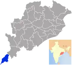 Location in Odisha, India | |
| Coordinates: 18.25°N 82.13°E | |
| Country | |
| State | |
| Headquarters | Malkangiri |
| Government | |
| • Collector & District Magistrate | Manish Agarwal, IAS |
| • Superintendent of Police | Rishikesh Dnyandeo Khilari, IPS |
| Area | |
| • Total | 5,791 km2 (2,236 sq mi) |
| Elevation | 195 m (640 ft) |
| Population (2011) | |
| • Total | 613,192 |
| • Density | 83/km2 (210/sq mi) |
| Languages | |
| • Official | Odia, English |
| • Other Local Language | Koya, Kuvi, Gutob |
| Time zone | UTC+5:30 (IST) |
| PIN | 764 xxx |
| Vehicle registration | OD-30 |
| Sex ratio | 1.004 ♂/♀ |
| Literacy | 49.49%[1] |
| Lok Sabha constituency | Nabarangpur(ST) |
| Vidhan Sabha constituency | 2
|
| Climate | Aw (Köppen) |
| Precipitation | 1,700 millimetres (67 in) |
| Avg. summer temperature | 47 °C (117 °F) |
| Avg. winter temperature | 13 °C (55 °F) |
| Website | malkangiri |
| This article is part of a series on |
| Odisha |
|---|
 |
| Governance |
|
| Topics |
|
Districts Divisions |
| GI Products |
|
|
Etymology
One etymology of Malkangiri is that of Mallikeshwar, who was worshipped by ancient kings of the area, after whom they named their kingdom: Mallika Nagari. This eventually shortened to Malkangiri. The district was formerly known as Malikamardhangiri, named for Malikamardhana, the name of a king of Jeypore. He took the title after defeating a general of the Golconda Sultanate named Malik Mohammad. He also constructed a fort named Malikamardhanghada: for which the entire area was named.
History
Local legend claims Valmiki wrote the Ramayana on the banks of the Tamasa river. The region was known as Malyavantagiri in the Ramayana, and it was believed Sitakunda was the bathing-place of Sita, near Mudulipada. Local legend claims the Pandavas spent a year in exile in the dense forests of Malkangiri. Kanamraju, Balaraju and Poturaju are the three famous Lords of this area, who are being worshiped by the people. On every alternative year, Badayatra, the festival of these Lords is celebrated throughout the district.
Prior to 1936, Malkangiri was a part of Koraput district of the Madras Presidency. In 1936, Koraput District was merged into Odisha and Malkangiri Tahasil was included in Koraput District. This Tahasil was a part of Nawarangpur sub-division of Koraput District. On 1 January 1962, Malkangiri subdivision was carved out. In 1958, refugees from East Pakistan were settled in the area in the Dandakaranya Project. This project continued for 30 years until it was declared closed in the year 1988.
Finally on 2 October 1992, Malkangiri was carved out of Koraput District. Today, the district has become known as a hotbed for Maoist activities.[2]
Administrative setup
There are 07 Blocks and 07 Tahasils under one Sub-Division in Malkangiri district are listed in the following table.
| # | 07 Blocks | 07 Tahasils |
|---|---|---|
| 1 | Malkangiri | Malkangiri |
| 2 | Mathili | Mathili |
| 3 | Khairput | Khairput |
| 4 | Chitrakonda | Chitrakonda |
| 5 | Korukonda | Kudumulgumma |
| 6 | Kalimela | Kalimela |
| 7 | Podia | Motu |
There are 12 Police Stations under two Police Sub-Divisions in Malkangiri district are listed in the following table.
| Malkangiri Police Sub-Division | Chitrakonda Police Sub-Division | |
|---|---|---|
| 1 | Malkangiri P.S. | Chitrakonda P.S. |
| 2 | Mathili P.S. | Mudulipada P.S. |
| 3 | Podia P.S. | Orkel P.S. |
| 4 | Kalimela P.S. | Jodamba P.S. |
| 5 | M.V. 79 P.S. | Papermetla P.S. |
| 6 | Motu P.S. | |
| 7 | Energy P.S., Malkangiri |
Economy
In 2006 the Ministry of Panchayati Raj named Malkangiri one of the country's 250 most backward districts (out of a total of 640).[3] It is one of the 19 districts in Odisha currently receiving funds from the Backward Regions Grant Fund Programme (BRGF).[3]
Demographics
According to the 2011 census Malkangiri district has a population of 613,192,[4] roughly equal to the nation of Solomon Islands[5] or the US state of Vermont.[6] This gives it a ranking of 523rd in India (out of a total of 640).[4] The district has a population density of 106 inhabitants per square kilometre (270/sq mi) .[4] Its population growth rate over the decade 2001-2011 was 21.53%.[4] Malkangiri has a sex ratio of 1016 females for every 1000 males,[4] and a literacy rate of 49.49%.[4] 22.6% and 57.8% of the population are made up of Scheduled Castes and Scheduled Tribes respectively.
The largest tribes are the Koya and Bhumia. Other major tribes include the Porja, Khond and Gadaba.
At the time of the 2011 Census of India, 41.99% of the population in the district spoke Odia, 23.40% Koya, 21.48% Bengali, 2.97% Telugu, 2.59% Kuvi and 1.36% Halbi as their first language.[7]
| Year | Pop. | ±% p.a. |
|---|---|---|
| 1901 | 58,275 | — |
| 1911 | 70,059 | +1.86% |
| 1921 | 67,874 | −0.32% |
| 1931 | 80,047 | +1.66% |
| 1941 | 94,894 | +1.72% |
| 1951 | 106,637 | +1.17% |
| 1961 | 141,955 | +2.90% |
| 1971 | 268,865 | +6.60% |
| 1981 | 335,169 | +2.23% |
| 1991 | 422,326 | +2.34% |
| 2001 | 504,198 | +1.79% |
| 2011 | 613,192 | +1.98% |
| source:[8] | ||
Languages of Malkangiri district in 2011 census
Politics
Vidhan sabha constituencies
Malkangiri has 2 Vidhan Sabha constituencies, electing members to the Odisha Legislative Assembly:[9][10][11][12]
| No. | Constituency | Reservation | Extent of the Assembly Constituency (Blocks) | Member of 14th Assembly | Party |
|---|---|---|---|---|---|
| 146 | Malkangiri | ST | Malkangiri (NAC), Kalimela, Malkangiri, Podia, Korukunda (part) | Aditya Madhi | BJP |
| 147 | Chitrakonda | ST | Balimela (NAC), Mathili, Kudumulugumma, Khairaput, Korukonda (part) | Purna Chandra Baka | BJD |
References
- http://ordistricts.nic.in/district_profile/dist_glance.php
- "History | District Malkangiri, Government Of Odisha | India". Retrieved 30 August 2020.
- Ministry of Panchayati Raj (8 September 2009). "A Note on the Backward Regions Grant Fund Programme" (PDF). National Institute of Rural Development. Archived from the original (PDF) on 5 April 2012. Retrieved 27 September 2011.
- "District Census 2011". Census2011.co.in. 2011. Retrieved 30 September 2011.
- US Directorate of Intelligence. "Country Comparison:Population". Retrieved 1 October 2011.
Solomon Islands 571,890 July 2011 est.
- "2010 Resident Population Data". U. S. Census Bureau. Archived from the original on 28 October 2011. Retrieved 30 September 2011.
Vermont 625,741
- 2011 Census of India, Population By Mother Tongue
- Decadal Variation In Population Since 1901
- Assembly Constituencies and their EXtent
- Seats of Odisha
- "List of Member in Fourteenth Assembly". ws.ori.nic.in. Archived from the original on 2 May 2007. Retrieved 19 February 2013.
Member Name
- "Odisha Legislative Assembly". odishaassembly.nic.in. Retrieved 2 July 2020.
External links
Places adjacent to Malkangiri district | |
|---|---|
Capital: Bhubaneswar | |||||||
| State symbols |  | ||||||
| Governance | |||||||
| History | |||||||
| Geography | |||||||
| Districts by division |
| ||||||
| Cities | |||||||
| GI products | |||||||
| Topics | |||||||