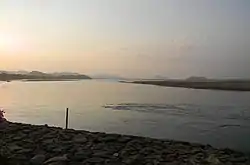
Nayagarh district
Nayagarh district is one of the 30 districts of Odisha state in eastern India. It was created in 1992 when the erstwhile Puri District was split into three distinct districts, namely Khurdha, Nayagarh and Puri. It is home to the Baisipali Wildlife Sanctuary. It is like a Hill station, so far as natural scenery is concerned. Chhena Poda is the favourite sweet for which Nayagarh is famous in Odisha. The name Odisha originated from Odra or Udra tribes that inhabited the central coastal belt (Khordha District and Nayagarh District) of modern Odisha. In ancient times the vast area from the river Ganges in the north to that of the Godavari in the south and from the Bay of Bengal in the east to the Amarkantaka hill in the west, was occupied by four important tribes and it is after them that the political units were named as Kalinga, Kosala, Odra and Utkala. Of these four Kalinga in ancient times exercised her control over rest of the three units, but later on it was confined to the region between the Mahanadi and the Godavari rivers. Kosala on the western sector, comprised the territories, now in Raipur, Bilaspur districts of Chhattisgarh and Sambalpur, Sundargarh, Bolangir and Kalahandi districts of modern Orissa. Rest of Orissa to the north of the river Mahanadi up to the Ganges in ancient times, was known as Utkala and Odra.
Nayagarh district | |
|---|---|
 | |
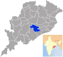 Location in Odisha, India | |
| Coordinates: 20.116°N 85.01°E | |
| Country | |
| State | |
| Headquarters | Nayagarh |
| Government | |
| • Collector & District Magistrate | Hemanta Kumar Padhi, IAS |
| • Member of Lok Sabha | Pinaki Misra |
| Area | |
| • Total | 3,890 km2 (1,500 sq mi) |
| Population (2011) | |
| • Total | 962,789 |
| • Density | 250/km2 (640/sq mi) |
| Languages | |
| • Official | Odia, English |
| Time zone | UTC+5:30 (IST) |
| PIN | 752069 |
| Vehicle registration | OD-25 |
| Sex ratio | 0.994 ♂/♀ |
| Lok Sabha constituency | Puri |
| Climate | Aw (Köppen) |
| Precipitation | 1,449.1 millimetres (57.05 in) |
| Website | www |
| This article is part of a series on |
| Odisha |
|---|
 |
| Governance |
|
| Topics |
|
Districts Divisions |
| GI Products |
|
|
History
Nayagarh princely state was created around the 13th century and is considered as an important part in the history of Odisha. King Suryamani of Baghela dynasty came to Puri and established his kingdom at Nayagarh. Present Nayagarh District consists of the four Garjat states (small provincial states ruled by the local kings) of ex-states Ranpur, Nayagarh, Khandapara and Daspalla. The aboriginal Savaras and Khonds are the indigenous people of Nayagarh District. The Indo-Aryans came later. Nayagarh District with its ex-states of Nayagarh, Khandapara, Daspalla and Ranpur played a major role in the freedom struggle of India.
The birth history of Nayagarh in the 13th century is an important chapter in the political history of Odisha. Suryamani of Baghela dynasty came to Puri on a pilgrimage from Rewa State in Madhya Pradesh and established his kingdom at Nayagarh. On the way to Puri, both Suryamani and his brother Chandramani took rest at night at Gunanati. The area was full of tigers and at night a tiger attacked him. Both the brothers fought the tiger and killed it. The local people praised the brave brothers and elected Suryamani as their leader. Suryamani gradually built his fort at Gunanati and married a Mali girl. After the death of his first wife, he again married a Kshatriya girl. From there, he then attacked Haripur and Ralaba. Ralaba was a very beautiful place. While sleeping a tiger attacked him at Ralaba; he again fought and killed it. At that moment, he saw a lady with an empty pot passed by to fetch water. Astonishingly, she returned with a little boy. Immediately, Suryamani obstructed the way of that lady and wanted to know about the mystery. The lady told she was Bouri Thakurani (a local worshiped goddess) and the tiger that the king killed was the boy. She advised Suryamani to kill her and worship her as his deity. From that date Suryamani worshiped Bauri Thakurani at Ralaba and built his fort there and adopted Tiger Head as a state symbol.
Ninth king of this dynasty Bagel Singh (1480–1510) came on a hunting to a place in between Rukshi and Balaram mountains and saw a wonderful sight that a rabbit pressed down a dog there. After seeing this extraordinary event, he selected and shifted his capital to this place. As per his name, this place was known as Baghua Nayagarh. The place where such an event occurred is now known as "Kukur Tasara".
12th King of Nayagarh Raghunath Sing (1565–1595) was highly powerful. During this time Muslims had already captured Odisha and the atmosphere of the coastal Odisha was fully indiscipline. Last independent king Mukunda Dev (1565) was defeated in Gohritikira and died. By taking the advantages of the political situations of coastal Odisha, Raghunath Singh attacked Ranapur and captured Odagaon, Sarankul and Baunsiapara area from Ranapur estate and dispossessed Nayagarh-Daspalla border area from the King of Boudh and Sunamuhin area of Odgaon from the King of Ghumusar. He also captured a portion from Banpur. Before death, Ragunath Singh divided his estate between his three sons. Harihar Singh was in possession of Nayagarh and Jadunath Singh got four Khandagrams (large area of land) which was later known as Khandapada. Gadadhar Singh was the son of Harihar Singh. When he was engaged in a fight with Ranpur estate, the king of Ghumusar attacked Nayagarh. Pindik Patsahani of village Sunalati with 150 soldiers fought the great army of Ghumusar and defeated him. But, in subsequent war he was captured by the enemy and sacrificed his life. Gadadhar Sing's daughter married the great poet Upendra Bhanja of Ghumusar who settled at Malisahi of Nayagarh estate after marriage. When British captured Odisha, Binayak Singh Mandhata was the King of Nayagarh and the great Jadumani (Utkal Ghanta) was his poet.
There were several Princely States in Nayagarh District. Nayagarh District was created in the year 1995. Prior to 1995 it was a subdivision of Puri district.[1][2]
Daspalla State was founded in the 15th century.
Rulers
Legend says that a demon named Gosinha was ruling this land during the epic period.Whose fort was located inside the Baisipalli Sanctuary, which was known as Goshinhagada during the epic period.
Available records, writings, books reveal that at first there was no such place known as Daspalla. Rather it was a part of Boudh State ruled by Bhanj Kings. During the rule of Bira Bhanj there was a rift in between Bira Bhanj and his cousin, Sal Bhanj. The dissident Sal Banj left Boudh and proceeded to meet the Gajapati of Puri through the ages old Jagannath Sadak. While resting with his followers at Padmlatola Forest, the king of Nayagarh got the news and made alliance with Sal Bhanj and declared him the king of that area. Getting the news, Bir Bhanj of Boudh got angry and sent a troop to capture Sal Bhanj. But the troop of Boudh got defeated at the hands of Sal Bhanj and Nayagarh soldiers. As Sal Bhanj got Yasha (Fame), he named his kingdom as Yashpalla or Daspalla. Other historians tell that king Sal Bhanj had only das (oriya for 10) Pallies (villages) so Daspalli got renamed as Daspalla. This incident took place in 1495. King Sal Bhanj ruled for 3 years only and then his son Naran Bhanj ascended the throne.
But records found at Boudh state reveal that Daspalla was formed by Naran Bhanj in 1498 during the reign of Siddya Bhanj. However, it is a fact that Daspalla was formed during the last part of 15th century being separated from Baudh.
The headquarters of Daspalla changed from Badmul to Gania, Gania to Madhyakhand, Madhyakhand to Puruna Daspalla. The ninth king of Daspalla Padmanav Bhanj, during hunting, saw a wonderful thing that a wild dove was hunting and defeating a Chhanchan (Bird of prey). So, he thought the place a heroic one and decided to change his capital to that place. At that time there was a Kandha chieftain named Kunj Malik. King Padmanav Bhanj defeated Kunj Malik and started his capital here but after the name of Kunja Malik the capital got named as Kunjabanagarh. Source-(Lankapodi Yatra, Mahaveer Kshetra, Daspalla, Odisha).
- 1653 – 1701 Chakradhar Deo Bhanj
- 1701 – 1753 Padmanav Deo Bhanj
- 1753 – 1775 Trilochan Deo Bhanj
- 1775 – 1795 Makunda Bhank Deo Bhanj
- 1795 – 1805 Guri Charan Deo Bhanj
- 1805 – 1845 Krishna Chanda Deo Bhanj
- 1845 – 1861 Madhusudan Deo Bhanj
- 1861 – 1873 Narsimha Bhanj
- 1873 – 1896 Chaitan Deo Bhanj
- 1896 – 1913 Narayan Deo Bhanj
- 1913 – 15 Aug 1947 Kishor Chandra Deo Bhanj (b. 1908)
Rajas
- 21 May 1874 - 1896 Chaitan Deo Bhanj (s.a.)
- 1896 - 11 Dec 1913 Narayan Deo Bhanj (b. 1860 - d. 1913)
- 11 Dec 1913 - 15 Aug 1947 Kishor Chandra Deo Bhanj (b. 1908 - d. 1960)
- 11 Dec 1913 - 3 Mar 1930 -Regent
Khandpara State. Founded in the 17th century by a former Raja of Rewah or by the Raja Raghunath Singh of Nayagarh, who had two sons, the elder son, Harihar Singh, became Raja of Nayagarh, and the younger, Jadunath Singh Mangraj, retained possession of four Garhs, or forts, as his share, viz. Kadua, Ghuntsahi, Sardhapur, and Khepada, all in Nayagarh. Up to the reign of Raja Narayan Singh Mangraj, Khandpara extended on the east up to Banki, on the west to Balaramprasad in Daspalla, on the north to Kantilo, and on the south up to Jogiapali in Nayagarh.
Rajas
- 1675 - 1709 Narayan Singh Mardraj
- 1709 - 1723 Balunkeswar Singh Mardraj
- 1723 - 1732 Banamall Singh Mardraj
- 1734 - 1770 Bairagi Singh Mardraj
- 1770 - 1794 Niladri Singh Mardraj
- 1794 - 1815 Narasimha Singh Mardraj
- 1815 - 1821 Purushottam Mardraj
- 1821 - 1842 Krishna Chandra Singh
- 1842 - 1867 Kunja Bihari Singh
- 28 Feb 1867 - 1905 Natobar Mardraj Bhramarbar Rai (b. 1837 - d. 1905?)
- 1905 - 26 Dec 1922 Ram Chandra Singh Mardraj Bhramarbar Rai
- 26 Dec 1922 - 15 Aug 1947 Harihar Singh Deo Mardraj Bhramarbar Rai (b. 1914 - d. 1977)
Nayagarh
Nayagarh State was founded in 1550.
Rajas
- Chandrasekhar Singh Mandhata
- Purushottam Singh Mandhata
- - 1784 Mrutyunjay Singh Mandhata
- 1784 - 1825 Binayak Singh Mandhata
- 1825 - 1851 Braja Bandhu Singh Mandhata
- 30 Sep 1851 - 1889 Ladu Kishor Singh Mandhata (b. c. 1843 - d. ....)
- 1889 - 1890 Balbhadra Singh
- 2 Mar 1890 - 4 Sep 1897 Raghunath Singh Mandhata
- 1897 - 7 Dec 1918 Narayan Singh Mandhata
- 7 Dec 1918 - 15 Aug 1947 Krishnachandra Singh Mandhata (b. 1911 - d. 1983)
Brajendra Kishore Singh Mandhata
(*)Present King of Nayagarh is Raja Saheb Gajendra Chandra Singh
The legendary date of foundation of Ranpur State is 18th century BC.
Ranpur State- Legend has it that the State was founded in about 1727 B.C. by Biswabasab,brother of the great devotee Biswabasu (who is related to the origin of the cult of Jagannath). The family of Ranpur Rajas claimed themselves to have descended from the Solar dynasty of Orissa. According to tradition, Biswabasab and Biswabasu actually belonged to the Sora tribe. Biswabasab conquered the Bhuyans and established his kingdom. At that time, the State is said to have extended up to Boudgarh in the west, Chilika lake in the south, and Daya and Mahanadi rivers in the east and north respectively.[3]
- 1692 - 1727 Ramachandra Narendra
- 1727 - 1754 Sarangadhar Bajradhar Narendra
- 1754 - 1789 Narsingh Bajradhar Narendra
- 1789 - 1821 Brujdaban Bajradhar Narendra
- 1821 - 1842 Brajsundar Bajradhar Narendra
- 1842 - 1899 Benudar Bajradhar Narendra (b. 1817 - d. ....)
- 12 Jul 1899 - 21 Jun 1945 Krishna Chandra Narendra (b. 1875 - d. 1945)
- 21 Jun 1945 - 1947 Brajendra Chandra Narendra (b. 1928 - d. 1980).
Maoist attacks
The district is currently a part of the Red Corridor.[4] On 15 February 2008, a number of police facilities across the district came under attack from maoist rebels resulting in the death of 13 police officers and 1 civilian. During the raid, the rebels stole a number of weapons.[5] Targets of the attack were the police training school, the police armoury and a police station. The fighting lasted about one and a half hours.[6]
Demographics
| Year | Pop. | ±% p.a. |
|---|---|---|
| 1901 | 331,061 | — |
| 1911 | 337,561 | +0.19% |
| 1921 | 303,665 | −1.05% |
| 1931 | 336,493 | +1.03% |
| 1941 | 363,652 | +0.78% |
| 1951 | 392,506 | +0.77% |
| 1961 | 470,878 | +1.84% |
| 1971 | 578,498 | +2.08% |
| 1981 | 683,392 | +1.68% |
| 1991 | 782,647 | +1.37% |
| 2001 | 864,516 | +1.00% |
| 2011 | 962,789 | +1.08% |
| source:[7] | ||
According to the 2011 census, Nayagarh district has a population of 962,789,[8] roughly equal to the nation of Fiji[9] or the US state of Montana.[10] This gives it a ranking of 453rd in India (out of a total of 640).[8] The district has a population density of 247 inhabitants per square kilometre (640/sq mi) .[8] Its population growth rate over the decade 2001-2011 was 11.3%.[8] Nayagarh has a sex ratio of 916 females for every 1000 males,[8] and a literacy rate of 79.17%.[8]
Languages of Nayagarh district in 2011 census
At the time of the 2011 Census of India, 99.09% of the population in the district spoke Odia as their first language.[11]
Transportation
Nayagarh was put on the railway map of the country on 19 June 2017 when railway minister Suresh Prabhu formally dedicated the new line from Bolagarh Road to Nayagarh as part of the ongoing Khurda Road-Balangir project. The railway minister also inaugurated the Nayagarh Town Station building while flagging off a passenger train that made the first journey to the town. A Rajsunakhala to Nayagarh train is currently available.
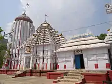
Visiting places

- Jagannath Temple, Nayagarh
- Baisipali Wildlife Sanctuary
- Maa Dakshina Kali Temple, Nayagarh
- Sri Nilakantheswar Temple, GambhariDihi, Nayagarh
- Ladoo Baba Temple, Sarankul
- Raghunath Temple, Odagaon
- Bhimara range,Daspalla
- Nilamadhab Temple, Kantilo
- Maa Maninaga Temple, Rana pur
- Jagannath Temple, Ranpur
- Maa KAUNRI Temple, Rajsunakhala
- Brundaban Chandra Matha, Ratnapur Sahi Rajsunakhala
- Kotagada Gumpha, Rajsunakhala
- Maa Tarini Temple, Shyamghan pur, Near Ranpur petrol tank
- Dutikeshwar Temple, Bahadajhola, Odagaon
- Mahaveer kshetra, Daspalla
- Maa Kaunri & Somanath Dev, Govindapur
- Maa Mahamaya Temple, Jemadeipur Sasan
- Budhabudhiani Dam, Odagaon
- Kuanria Dam, Daspalla
- Baradaini Hill, Daspalla
- Tarabalo Hot Springs, Fategarh
- Raghunath jiu temple, Dhenkena
- Gatiswaar temple, Malisahi
- Hanuman Mandir,Rajigiri Hill, Malisahi
Politics
(119)Ranpur remains with Puri Lok Sabha constituency after delimitation. (120)Khandapada was a part of Bhubaneswar Lok Sabha constituency. After delamination it is part of Cuttack Lok Sabha constituency from 2009. (121)Daspalla(SC) was a part of Bhubaneswar Lok Sabha constituency. After delamination it is part of Kandhamal Lok Sabha constituency from 2009. (122)Nayagarh was a part of Bhubaneswar Lok Sabha constituency. After delamination it is part of Puri Lok Sabha constituency from 2009.
Vidhan sabha constituencies
The following is the 4 Vidhan sabha constituencies[12][13] of Nayagarh district and the elected members[14] of that area
| No. | Constituency | Reservation | Extent of the Assembly Constituency (Blocks) | Member of 15th Assembly | Party |
|---|---|---|---|---|---|
| 119 | Ranpur | None | Ranpur, Odagaon (part) | Rabinarayan Mohapatra | BJD |
| 120 | Khandapada | None | Khandapada (NAC), Khandapada, Bhapur | Anubhav Patnaik | BJD |
| 121 | Daspalla | SC | Daspalla, Gania, Nuagaon | Purna Chandra Nayak | BJD |
| 122 | Nayagarh | None | Nayagarh (NAC), Nayagarh, Odagaon (part) | Arun Kumar Sahu | BJD |
References
- Princely States of Nayagarh District
- Princely States
- Satpathy, Bijayashree (November 2017). "Forest Rights Act Implementation in Odisha: Redressing Historical Injustices". South Asia Research. 37 (3): 259–276. doi:10.1177/0262728017725621. ISSN 0262-7280.
- "83 districts under the Security Related Expenditure Scheme". IntelliBriefs. 2009-12-11. Retrieved 2011-09-17.
- "Indian maoists killed 14 in Orissa". BBC. 2008-02-16. Retrieved 2008-02-16.
- "13 police personnel killed in Naxal attack in Orissa". headlines india. Retrieved 2008-02-16.
- Decadal Variation In Population Since 1901
- "District Census 2011". Census2011.co.in. 2011. Retrieved 2011-09-30.
- US Directorate of Intelligence. "Country Comparison:Population". Retrieved 2011-10-01.
Fiji 883,125 July 2011 est.
- "2010 Resident Population Data". U. S. Census Bureau. Archived from the original on 2013-10-19. Retrieved 2011-09-30.
Montana 989,415
- 2011 Census of India, Population By Mother Tongue
- Assembly Constituencies and their EXtent
- Seats of Odisha
- "List of Member in Fourteenth Assembly". ws.ori.nic.in. Archived from the original on 2 May 2007. Retrieved 19 February 2013.
External links
| Wikimedia Commons has media related to Nayagarh district. |
Places adjacent to Nayagarh district | |
|---|---|
Capital: Bhubaneswar | |||||||
| State symbols |  | ||||||
| Governance | |||||||
| History | |||||||
| Geography | |||||||
| Districts by division |
| ||||||
| Cities | |||||||
| GI products | |||||||
| Topics | |||||||