Naguabo, Puerto Rico
Naguabo (Spanish pronunciation: [naˈɣwaβo]) is a municipality in Puerto Rico located in the east coast of the island, north of Humacao; south of Río Grande and Ceiba; and east of Las Piedras. Naguabo is spread over 8 barrios and Naguabo Pueblo (the downtown area and the administrative center of the city). It is part of the San Juan-Caguas-Guaynabo Metropolitan Statistical Area.
Naguabo
Municipio de Naguabo | |
|---|---|
Town and Municipality | |
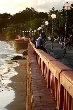 Beach, boardwalk, people and street lamps in Naguabo | |
 Flag  Coat of arms | |
| Nicknames: "Cuna de Grandes Artistas", "Los Enchumbaos" | |
| Anthem: "Naguabo es mi Pueblo" | |
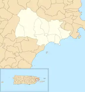
 Map of Puerto Rico highlighting Naguabo Municipality | |
| Coordinates: 18°13′10″N 65°44′12″W | |
| Commonwealth | |
| Founded | July 15, 1821 |
| Barrios | |
| Government | |
| • Mayor | Noé Marcano (PNP) |
| • Senatorial dist. | 7 - Humacao |
| • Representative dist. | 35 |
| Area | |
| • Total | 60.1 sq mi (155.57 km2) |
| • Land | 52.1 sq mi (135 km2) |
| • Water | 7.9 sq mi (20.57 km2) |
| Population (2010) | |
| • Total | 26,720 |
| • Density | 440/sq mi (170/km2) |
| Demonym(s) | Naguabeños |
| Time zone | UTC−4 (AST) |
| ZIP Codes | 00718, 00744 |
| Area code(s) | 787/939 |
| Major routes | |
Naguabo is said to be the birthplace of the pastelillo de chapín, which is a popular food in Puerto Rico. It is trunkfish wrapped inside a flour dough that is deep fried. Pastelillo de chapín can be found in almost any seaside establishment on the island.
History
The town of Naguabo was founded near a ravine on the east coast and relocated in 1821 to its current location. In 1878, Naguabo had the following barrios: Pueblo, Maizales, Duque, Mariana, Quebrada Palma, Daguao, Santiago y Lima, Húcares, Río, Peña Pobre and Río Blanco. In 1521, Daguao was burned down by Caribs.[1][2][3]
Geography
Naguabo is located in the southeast region of Puerto Rico. The northern part is within the Luquillo Mountain Range, which contain the Picos (tips) of the Este and the Oeste, at 3,448 and 3,346 feet (1,051 and 1,020 m) of altitude above sea level, respectively.[4][5]
Río Blanco and Río Espiritu Santo are located in Naguabo.[6]
Barrios
Like all municipalities of Puerto Rico, Naguabo is subdivided into barrios. The municipal buildings, central square and large Catholic church are located in a barrio referred to as "el pueblo".[7][8][9][10]
Sectors
Barrios (which are like minor civil divisions)[11] and subbarrios,[12] in turn, are further subdivided into smaller local populated place areas/units called sectores (sectors in English). The types of sectores may vary, from normally sector to urbanización to reparto to barriada to residencial, among others.[13][14][15]
Special Communities
Comunidades Especiales de Puerto Rico (Special Communities of Puerto Rico) are marginalized communities whose citizens are experiencing a certain amount of social exclusion. A map shows these communities occur in nearly every municipality of the commonwealth. Of the 742 places that were on the list in 2014, the following barrios, communities, sectors, or neighborhoods were in Naguabo: Relámpago neighborhood, Río, Santiago y Lima, Daguao, La Florida, Casco Urbano in barrio-pueblo, Húcares, Maizales, and Río Blanco.[16]
Demographics
Puerto Rico was ceded by Spain in the aftermath of the Spanish–American War under the terms of the Treaty of Paris of 1898 and became a territory of the United States. In 1899, the United States conducted its first census of Puerto Rico finding that the population of Naguabo was 10,873.
| Historical population | |||
|---|---|---|---|
| Census | Pop. | %± | |
| 1900 | 10,873 | — | |
| 1910 | 14,365 | 32.1% | |
| 1920 | 15,788 | 9.9% | |
| 1930 | 18,212 | 15.4% | |
| 1940 | 19,180 | 5.3% | |
| 1950 | 21,019 | 9.6% | |
| 1960 | 17,195 | −18.2% | |
| 1970 | 17,996 | 4.7% | |
| 1980 | 20,617 | 14.6% | |
| 1990 | 22,620 | 9.7% | |
| 2000 | 23,753 | 5.0% | |
| 2010 | 26,720 | 12.5% | |
| U.S. Decennial Census[17] 1899 (shown as 1900)[18] 1910-1930[19] 1930-1950[20] 1960-2000[21] 2010[9] | |||
Tourism
Landmarks and places of interest
There are 31 beaches in Naguabo.[22] The main attractions in Naguabo are:
- Algodones Key
- El Yunque National Forest (South Side via PR State Road 191 - Closed at KM 13 (mile marker 8.1) (approx.) due to Road Closure)
- Naguabo Beach
- Punta Lima Beach
- Ramón Rivero "Diplo" Monument
- Tropical Beach
- Yudelmi Center
- Pedro Flores Monument
- Hucares Waterfront (El Malecón - Boardwalk)
- City Square (Plaza De Recreo)
Culture
Festivals and events
Naguabo celebrates its patron saint festival in October. The Fiestas Patronales de Nuestra Virgen del Rosario is a religious and cultural celebration that generally features parades, games, artisans, amusement rides, regional food, and live entertainment.[5]
Other festivals and events celebrated in Naguabo include:
- Maratón Cervecero En Naguabo -January
- Chapín Festival - February
- Pedro Flores Week - March
- Diplo Festival - June
- Virgen del Carmen Fiesta - July 16
Symbols
Flag
This municipality has a flag.[23]
Coat of arms
This municipality has a coat of arms.[23]
Transportation
There is public transportation in Naguabo. It operates from 6:00 a.m. using the "Pisicorre" bus.[24][25] There are 52 bridges in Naguabo.[26]
Books about Naguabo
Historia de Naguabo by Carmelo Rosario Natal
Gallery
 Río Blanco reservoir in Naguabo
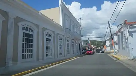 Street in Naguabo
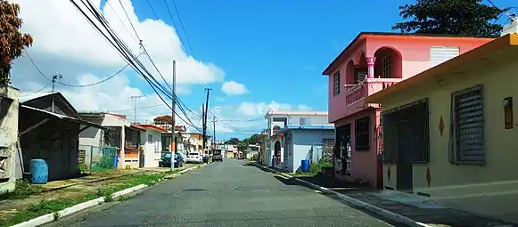 Residential street in Naguabo
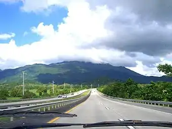 Highway from Naguabo to Ceiba
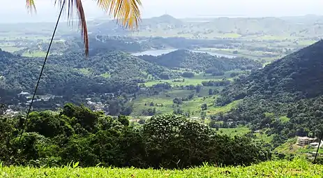
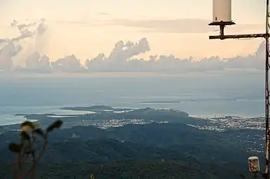 Northeast Puerto Rico from atop El Yunque
.jpg.webp) Radar towers in Naguabo
Radar towers in Naguabo
See also
- List of Puerto Ricans
- History of Puerto Rico
- Did you know-Puerto Rico?
References
- De Córdova, Pedro Tomás, Memorias geográficas, históricas, económicas y estadisticas de la Isa de Puerto Rico, 1831, tomo 2, pág. 299
- de Ubeda y Delgado, Manuel (1878). Puerto Rico: Estudio Histórico, Geográfico y Estadístico de la Misma. HathiTrust. p. 277. Retrieved 29 October 2020.
- "La Historia de Puerto Rico a través de sus Barrios: Daguao de Naguabo [The History of Puerto Rico through its Barrios: Daguao in Naguabo]" (video). www.pbslearningmedia.org (in Spanish). Fundación Puertorriqueña de las Humanidades. Retrieved 29 August 2020.
- "Barrios de Puerto Rico: Barrio Daguao de Naguabo". PBS Learning Media. Florida PBS. Archived from the original on 1 December 2017. Retrieved 27 November 2017.
- "Naguabo Municipality". enciclopediapr.org. Fundación Puertorriqueña de las Humanidades (FPH). Archived from the original on 2017-11-21. Retrieved 2019-03-20.
- "Rescatan a seis personas por inundaciones en Naguabo [Six people rescued after flooding in Naguabo]". El Nuevo Día (in Spanish). 30 July 2019. Retrieved 29 August 2020.
- Picó, Rafael; Buitrago de Santiago, Zayda; Berrios, Hector H. Nueva geografía de Puerto Rico: física, económica, y social, por Rafael Picó. Con la colaboración de Zayda Buitrago de Santiago y Héctor H. Berrios. San Juan Editorial Universitaria, Universidad de Puerto Rico,1969. Archived from the original on 2018-12-26. Retrieved 2019-01-12.
- Gwillim Law (20 May 2015). Administrative Subdivisions of Countries: A Comprehensive World Reference, 1900 through 1998. McFarland. p. 300. ISBN 978-1-4766-0447-3. Retrieved 25 December 2018.
- Puerto Rico:2010:population and housing unit counts.pdf (PDF). U.S. Dept. of Commerce Economics and Statistics Administration U.S. Census Bureau. 2010. Archived (PDF) from the original on 2017-02-20. Retrieved 2018-12-27.
- "Map of Naguabo at the Wayback Machine" (PDF). Archived from the original (PDF) on 2018-03-24. Retrieved 2018-12-29.
- "US Census Barrio-Pueblo definition". factfinder.com. US Census. Archived from the original on 13 May 2017. Retrieved 5 January 2019.
- "P.L. 94-171 VTD/SLD Reference Map (2010 Census): Naguabo Municipio, PR" (PDF). www2.census.gov. U.S. DEPARTMENT OF COMMERCE Economics and Statistics Administration U.S. Census Bureau. Archived (PDF) from the original on 22 August 2020. Retrieved 22 August 2020.
- "Agencia: Oficina del Coordinador General para el Financiamiento Socioeconómico y la Autogestión (Proposed 2016 Budget)". Puerto Rico Budgets (in Spanish). Archived from the original on 28 June 2019. Retrieved 28 June 2019.
- Rivera Quintero, Marcia (2014), El vuelo de la esperanza: Proyecto de las Comunidades Especiales Puerto Rico, 1997-2004 (first ed.), San Juan, Puerto Rico Fundación Sila M. Calderón, ISBN 978-0-9820806-1-0
- "Leyes del 2001". Lex Juris Puerto Rico (in Spanish). Archived from the original on 14 September 2018. Retrieved 24 June 2020.
- Rivera Quintero, Marcia (2014), El vuelo de la esperanza:Proyecto de las Comunidades Especiales Puerto Rico, 1997-2004 (Primera edición ed.), San Juan, Puerto Rico Fundación Sila M. Calderón, p. 273, ISBN 978-0-9820806-1-0
- "U.S. Decennial Census". United States Census Bureau. Archived from the original on February 13, 2020. Retrieved September 21, 2017.
- "Report of the Census of Porto Rico 1899". War Department Office Director Census of Porto Rico. Archived from the original on July 16, 2017. Retrieved September 21, 2017.
- "Table 3-Population of Municipalities: 1930 1920 and 1910" (PDF). United States Census Bureau. Archived (PDF) from the original on August 17, 2017. Retrieved September 21, 2017.
- "Table 4-Area and Population of Municipalities Urban and Rural: 1930 to 1950" (PDF). United States Census Bureau. Archived (PDF) from the original on August 30, 2015. Retrieved September 21, 2014.
- "Table 2 Population and Housing Units: 1960 to 2000" (PDF). United States Census Bureau. Archived (PDF) from the original on July 24, 2017. Retrieved September 21, 2017.
- "Las 1,200 playas de Puerto Rico [The 1200 beaches of Puerto Rico]". Primera Hora (in Spanish). April 14, 2017. Archived from the original on December 12, 2019. Retrieved December 12, 2019.
- "NAGUABO". LexJuris (Leyes y Jurisprudencia) de Puerto Rico (in Spanish). 19 February 2020. Archived from the original on 19 February 2020. Retrieved 22 September 2020.
- María Isabel Quiñones Arocho (2004). El fin del reino de lo propio ensayos de antropologia cultural. Siglo XXI. pp. 104–. ISBN 968-23-2494-7. Archived from the original on 2020-08-22. Retrieved 2019-02-21.
- Garcia, Themis. "Understanding Collective Transportation". Medium. Archived from the original on 22 February 2019. Retrieved 21 February 2019.
- "Naguabo Bridges". National Bridge Inventory Data. US Dept. of Transportation. Archived from the original on 22 February 2019. Retrieved 20 February 2019.