National Register of Historic Places listings in Blaine County, Montana
This is a list of the National Register of Historic Places listings in Blaine County, Montana. It is intended to be a complete list of the properties and districts on the National Register of Historic Places in Blaine County, Montana, United States. The locations of National Register properties and districts for which the latitude and longitude coordinates are included below, may be seen in a map.[1]
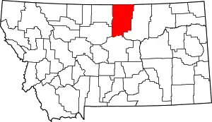
Location of Blaine County in Montana
There are 10 properties and districts listed on the National Register in the county.
- This National Park Service list is complete through NPS recent listings posted January 29, 2021.[2]
Listings county-wide
| [3] | Name on the Register | Image | Date listed[4] | Location | City or town | Description |
|---|---|---|---|---|---|---|
| 1 | Chief Joseph Battleground of the Bear's Paw | 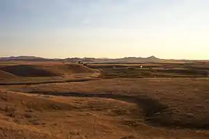 Chief Joseph Battleground of the Bear's Paw |
October 6, 1970 (#70000355) |
About 15 miles south of Chinook, T30NR19E, Sections 1 and 12 48°22′39″N 109°12′26″W |
Chinook | |
| 2 | Cow Creek Skirmish Historic District | June 28, 2019 (#100004104) |
Address Restricted |
Winifred vicinity | ||
| 3 | Cow Island Landing Skirmish Site |  Cow Island Landing Skirmish Site |
June 27, 2019 (#100004103) |
Approx. 28 mi. NE of Winifred 47°46′25″N 108°56′57″W |
Winifred vicinity | |
| 4 | Dave's Texaco | _-_Blaine_County%252C_Montana.png.webp) Dave's Texaco |
August 16, 1994 (#94000862) |
237 Pennsylvania St. 48°35′35″N 109°13′54″W |
Chinook | |
| 5 | Ervin Homestead-Gist Bottom Historic District | 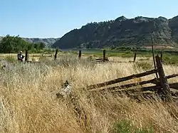 Ervin Homestead-Gist Bottom Historic District |
June 23, 2016 (#16000410) |
River Mile 122.3 Left 47°48′18″N 109°00′40″W |
Hays vicinity | Ranch homesteaded beside Missouri River in Missouri Breaks |
| 6 | Lodgepole Community Hall | February 24, 2000 (#00000148) |
Fort Belknap Indian Community 48°02′04″N 108°31′57″W |
Lodgepole | ||
| 7 | Lohman Block | 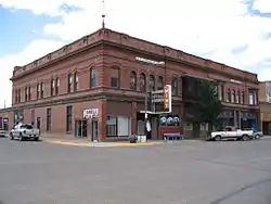 Lohman Block |
March 19, 1980 (#80002399) |
239-225 Indiana St. 48°35′35″N 109°13′49″W |
Chinook | |
| 8 | St. Paul's Mission Church | July 31, 2020 (#100005403) |
1 Mission Dr. 47°58′35″N 108°40′30″W |
Hays | ||
| 9 | Anna Scherlie Homestead Shack | November 5, 1998 (#98001338) |
Montana Highway 241, south of the Canada–US border 48°51′01″N 108°23′26″W |
Turner | ||
| 10 | Young Brothers Chevrolet Garage | 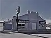 Young Brothers Chevrolet Garage |
August 16, 1994 (#94000867) |
201 Pennsylvania St. 48°35′38″N 109°13′54″W |
Chinook |
See also
| Wikimedia Commons has media related to National Register of Historic Places in Blaine County, Montana. |
References
- The latitude and longitude information provided in this table was derived originally from the National Register Information System, which has been found to be fairly accurate for about 99% of listings. Some locations in this table may have been corrected to current GPS standards.
- "National Register of Historic Places: Weekly List Actions". National Park Service, United States Department of the Interior. Retrieved on January 29, 2021.
- Numbers represent an alphabetical ordering by significant words. Various colorings, defined here, differentiate National Historic Landmarks and historic districts from other NRHP buildings, structures, sites or objects.
- The eight-digit number below each date is the number assigned to each location in the National Register Information System database, which can be viewed by clicking the number.
| Topics | |
|---|---|
| Lists by state |
|
| Lists by insular areas | |
| Lists by associated state | |
| Other areas | |
| Related | |
| |
Municipalities and communities of Dawson County, Montana, United States | ||
|---|---|---|
| City | 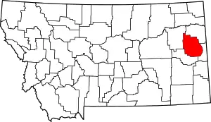 Dawson County map | |
| Town | ||
| CDP | ||
| Unincorporated communities | ||
| ||
This article is issued from Wikipedia. The text is licensed under Creative Commons - Attribution - Sharealike. Additional terms may apply for the media files.