National Register of Historic Places listings in Chouteau County, Montana
This is a list of the National Register of Historic Places listings in Chouteau County, Montana. It is intended to be a complete list of the properties and districts on the National Register of Historic Places in Chouteau County, Montana, United States. The locations of National Register properties and districts for which the latitude and longitude coordinates are included below, may be seen in a map.[1]
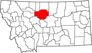
Location of Chouteau County in Montana
There are 21 properties and districts listed on the National Register in the county, including 1 National Historic Landmark.
- This National Park Service list is complete through NPS recent listings posted January 29, 2021.[2]
Listings county-wide
| [3] | Name on the Register | Image | Date listed[4] | Location | City or town | Description |
|---|---|---|---|---|---|---|
| 1 | I.G. Baker House | 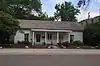 I.G. Baker House |
November 20, 1980 (#80002403) |
1604 Front St. 47°49′08″N 110°39′35″W |
Fort Benton | |
| 2 | Chouteau County Courthouse | 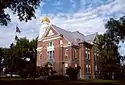 Chouteau County Courthouse |
September 29, 1980 (#80002404) |
1308 Franklin St. 47°49′03″N 110°39′53″W |
Fort Benton | |
| 3 | Citadel Rock | 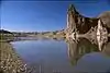 Citadel Rock |
November 13, 1974 (#74001095) |
East of Fort Benton 47°49′52″N 110°04′28″W |
Fort Benton | |
| 4 | Eagle Butte School | January 28, 2009 (#08001383) |
Eagle Butte School Rd., 23 miles off Montana Highway 80 47°53′09″N 110°10′12″W |
Fort Benton | ||
| 5 | First National Bank of Geraldine | 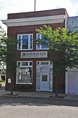 First National Bank of Geraldine |
January 9, 2008 (#07001363) |
311 Main St. 47°36′09″N 110°15′53″W |
Geraldine | |
| 6 | Fort Benton | 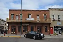 Fort Benton |
October 15, 1966 (#66000431) |
Front St. (1220 through 1900 block) levee, and bridge 47°49′04″N 110°40′02″W |
Fort Benton | |
| 7 | Fort Benton Bridge |  Fort Benton Bridge |
August 6, 1980 (#80002406) |
Spans the Missouri River 47°49′02″N 110°39′38″W |
Fort Benton | |
| 8 | Fort Benton Engine House | 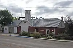 Fort Benton Engine House |
November 20, 1980 (#80002407) |
Front and 15th Sts. 47°49′02″N 110°39′38″W |
Fort Benton | |
| 9 | Geraldine Milwaukee Depot | 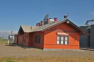 Geraldine Milwaukee Depot |
March 21, 1997 (#97000254) |
Railroad Ave., approximately 10 miles south of Montana Highway 80 47°36′14″N 110°15′55″W |
Geraldine | |
| 10 | Grand Union Hotel | 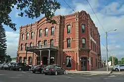 Grand Union Hotel |
January 2, 1976 (#76001121) |
14th and Front Sts. 47°48′52″N 110°40′08″W |
Fort Benton | |
| 11 | Judith Landing Historic District | 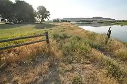 Judith Landing Historic District |
December 6, 1975 (#75001081) |
Upper Missouri River Breaks National Monument 47°44′14″N 109°37′34″W |
Winifred | Historic site managed by BLM; extends into Fergus County. Boundary increase on 2014-04-11. |
| 12 | Lewis and Clark Camp at Slaughter River | December 16, 1974 (#74001094) |
40 miles south of the Big Sandy River on the Missouri River 47°43′04″N 109°50′59″W |
Big Sandy | ||
| 13 | Lonetree | September 11, 1980 (#80002410) |
South of Geraldine 47°32′37″N 110°17′21″W |
Geraldine | ||
| 14 | Masonic Building | 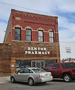 Masonic Building |
October 14, 1980 (#80002408) |
1418 Front St. 47°49′03″N 110°39′41″W |
Fort Benton | |
| 15 | St. Paul's Episcopal Church | 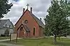 St. Paul's Episcopal Church |
September 29, 1980 (#80002409) |
14th and Chouteau Sts. 47°49′06″N 110°39′58″W |
Fort Benton | |
| 16 | Shonkin Creek Bridge | March 26, 2012 (#12000169) |
Approximately mile 21 on Shonkin Rd. 47°33′57″N 110°33′11″W |
Geraldine vicinity | part of the Montana's Steel Stringer and Steel Girder Bridges MPS | |
| 17 | Square Butte Jail | July 23, 1998 (#98000888) |
Salsbury Ave. 47°31′02″N 110°11′52″W |
Square Butte | ||
| 18 | Square Butte School | July 15, 2013 (#13000496) |
Northwest corner of Diederick St. and Broadway 47°31′00″N 110°12′08″W |
Square Butte | ||
| 19 | Teton River Crossing on the Whoop-Up Trail | April 15, 1993 (#93000275) |
Address Restricted |
Carter | ||
| 20 | Virgelle Mercantile and Virgelle State Bank | 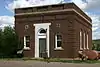 Virgelle Mercantile and Virgelle State Bank |
April 15, 1997 (#97000315) |
County Road 430, approximately 6.3 miles south of U.S. Route 87 48°00′57″N 110°14′55″W |
Virgelle | |
| 21 | West Quincy Granite Quarry | March 3, 2000 (#00000163) |
Flat Creek Rd. 47°32′42″N 110°16′58″W |
Square Butte |
Former listings
| [3] | Name on the Register | Image | Date listed | Date removed | Location | City or town | Summary |
|---|---|---|---|---|---|---|---|
| 1 | Chouteau County Jail | August 11, 1980 (#80002405) | June 3, 1986 | Washington and Fourteenth Sts. |
Fort Benton |
See also
| Wikimedia Commons has media related to National Register of Historic Places in Chouteau County, Montana. |
References
- The latitude and longitude information provided in this table was derived originally from the National Register Information System, which has been found to be fairly accurate for about 99% of listings. Some locations in this table may have been corrected to current GPS standards.
- "National Register of Historic Places: Weekly List Actions". National Park Service, United States Department of the Interior. Retrieved on January 29, 2021.
- Numbers represent an alphabetical ordering by significant words. Various colorings, defined here, differentiate National Historic Landmarks and historic districts from other NRHP buildings, structures, sites or objects.
- The eight-digit number below each date is the number assigned to each location in the National Register Information System database, which can be viewed by clicking the number.
| Topics | |
|---|---|
| Lists by state |
|
| Lists by insular areas | |
| Lists by associated state | |
| Other areas | |
| Related | |
| |
Municipalities and communities of Chouteau County, Montana, United States | ||
|---|---|---|
| City | Chouteau County map | |
| Towns | ||
| CDPs | ||
| Unincorporated communities | ||
| Ghost town | ||
| Indian reservations | ||
| Footnotes | ‡This populated place also has portions in an adjacent county or counties | |
| ||
This article is issued from Wikipedia. The text is licensed under Creative Commons - Attribution - Sharealike. Additional terms may apply for the media files.