National Register of Historic Places listings in Claiborne County, Mississippi
This is a list of the National Register of Historic Places listings in Claiborne County, Mississippi.
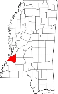
Location of Claiborne County in Mississippi
This is intended to be a complete list of the properties and districts on the National Register of Historic Places in Claiborne County, Mississippi, United States. Latitude and longitude coordinates are provided for many National Register properties and districts; these locations may be seen together in a map.[1]
There are 36 properties and districts listed on the National Register in the county, including 2 National Historic Landmarks. Another two properties were once listed but have been removed.
- This National Park Service list is complete through NPS recent listings posted February 5, 2021.[2]
Current listings
| [3] | Name on the Register[4] | Image | Date listed[5] | Location | City or town | Description |
|---|---|---|---|---|---|---|
| 1 | Alcorn State University Historic District | 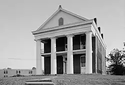 Alcorn State University Historic District |
May 20, 1982 (#82003098) |
Alcorn State University campus 31°52′32″N 91°08′59″W |
Lorman | |
| 2 | Bayou Pierre Site | June 23, 1978 (#78001596) |
Address Restricted |
Port Gibson | ||
| 3 | Bethel Presbyterian Church | 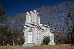 Bethel Presbyterian Church |
November 28, 1978 (#78001594) |
North of Alcorn on Mississippi Highway 552 31°54′21″N 91°07′44″W |
Alcorn | |
| 4 | Buena Vista Cotton Gin | December 27, 1974 (#74001059) |
Northeast of Port Gibson 31°59′23″N 90°54′35″W |
Port Gibson | ||
| 5 | Building at 801 Chinquepin Street | July 22, 1979 (#79003420) |
801 Chinquepin St. 31°57′18″N 90°58′41″W |
Port Gibson | ||
| 6 | Canemount | 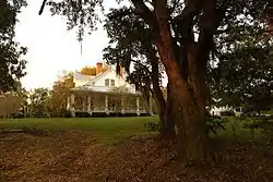 Canemount |
December 2, 1982 (#82000572) |
North of Alcorn off Mississippi Highway 552 31°53′40″N 91°07′34″W |
Alcorn | |
| 7 | Catholic Cemetery | .jpg.webp) Catholic Cemetery |
July 22, 1979 (#79003425) |
700 Coffee St. 31°57′21″N 90°58′43″W |
Port Gibson | |
| 8 | Catledge Archeological Site | July 15, 1974 (#74001058) |
Address Restricted |
Alcorn | ||
| 9 | Centers Creek Mound | August 14, 1973 (#73001003) |
Address Restricted |
Russum | ||
| 10 | Chamberlain-Hunt Academy Historic District | 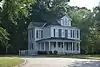 Chamberlain-Hunt Academy Historic District |
July 22, 1979 (#79003411) |
Roughly bounded by U.S. Route 61, the city limits, Woodstock St., and Mississippi Highway 547 31°56′43″N 90°59′12″W |
Port Gibson | |
| 11 | Claremont | July 22, 1979 (#79003418) |
366 Claremont Dr. 31°56′59″N 90°59′33″W |
Port Gibson | ||
| 12 | Collina | 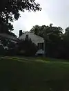 Collina |
July 22, 1979 (#79003419) |
Greenwood St. Extension 31°57′15″N 90°59′25″W |
Port Gibson | |
| 13 | Drake Hill Historic District | July 22, 1979 (#79003412) |
Drake Hill Rd. 31°57′36″N 90°59′17″W |
Port Gibson | ||
| 14 | Golden West Cemetery | July 22, 1979 (#79003417) |
Rodney Rd. 31°57′26″N 90°59′30″W |
Port Gibson | ||
| 15 | Grand Gulf Military State Park |  Grand Gulf Military State Park |
April 11, 1972 (#72000689) |
6 miles west of Port Gibson 31°31′58″N 91°03′00″W |
Port Gibson | |
| 16 | Idlewild | 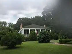 Idlewild |
July 22, 1979 (#79003416) |
310 Idlewild Dr. 31°57′00″N 90°59′14″W |
Port Gibson | |
| 17 | Jewish Cemetery |  Jewish Cemetery |
July 22, 1979 (#79003415) |
900 Marginal St. 31°57′22″N 90°58′45″W |
Port Gibson | |
| 18 | Market Street-Suburb Ste. Mary Historic District |  Market Street-Suburb Ste. Mary Historic District |
July 22, 1979 (#79003410) |
Roughly bounded by Orange, Marginal, Greenwood, and Market Sts. 31°57′27″N 90°58′56″W |
Port Gibson | |
| 19 | McGregor | July 22, 1979 (#79003424) |
Mississippi Highway 547 31°56′32″N 90°58′37″W |
Port Gibson | ||
| 20 | John Nelson Site | June 13, 1974 (#74001060) |
Address Restricted |
Willows | ||
| 21 | Oakland Chapel | .jpg.webp) Oakland Chapel |
December 27, 1974 (#74001057) |
Alcorn State University campus 31°52′33″N 91°08′22″W |
Alcorn | |
| 22 | Old Brickyard Place | July 22, 1979 (#79003423) |
Anthony St. 31°58′09″N 90°59′29″W |
Port Gibson | ||
| 23 | Old Depot Restaurant and Lounge | 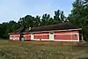 Old Depot Restaurant and Lounge |
July 22, 1979 (#79003421) |
1202 Market St. 31°57′20″N 90°59′15″W |
Port Gibson | |
| 24 | Old Natchez Trace (132-3T) | 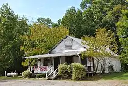 Old Natchez Trace (132-3T) |
November 7, 1976 (#76000161) |
Northeast of Port Gibson at milepost 45.8 of the Natchez Trace Parkway 32°00′10″N 90°53′46″W |
Port Gibson | An original segment of the Natchez Trace.[6] |
| 25 | Owens Creek Bridge | November 16, 1988 (#88002398) |
Spans Owen Creek on an old county road 32°05′29″N 90°43′45″W |
Utica | ||
| 26 | Port Gibson Battle Site | April 5, 2005 (#05000461) |
West of Port Gibson 31°57′28″N 91°01′08″W |
Port Gibson | ||
| 27 | Port Gibson Battlefield | November 3, 1972 (#72000690) |
4 miles west of Port Gibson 31°57′28″N 91°01′08″W |
Port Gibson | ||
| 28 | Port Gibson High School (Old) | May 17, 2016 (#16000285) |
161 Ramsey Dr. 31°57′07″N 90°59′13″W |
Port Gibson | ||
| 29 | Port Gibson Oil Works Mill Building | July 22, 1979 (#79003422) |
Anthony St. 31°57′55″N 90°59′26″W |
Port Gibson | ||
| 30 | Sacred Heart Roman Catholic Church | 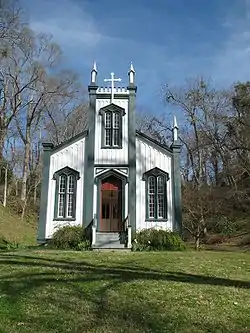 Sacred Heart Roman Catholic Church |
November 23, 1987 (#73002241) |
Grand Gulf Military Monument Park 32°02′00″N 91°03′11″W |
Port Gibson | |
| 31 | Smithfield Site | June 9, 1978 (#78001595) |
Address Restricted |
Bruinsburg | ||
| 32 | Van Dorn House | .jpg.webp) Van Dorn House |
June 21, 1971 (#71000446) |
Van Dorn Dr. 31°56′24″N 91°02′15″W |
Port Gibson | |
| 33 | Widow's Creek Bridge | November 16, 1988 (#88002409) |
Spans Widow's Creek on a county road 31°56′30″N 91°03′03″W |
Port Gibson | ||
| 34 | Windsor Ruins |  Windsor Ruins |
November 23, 1971 (#71000447) |
12 miles southwest of Port Gibson on Mississippi Highway 552 31°56′26″N 91°07′46″W |
Port Gibson | |
| 35 | Windsor Site | February 7, 1979 (#79003126) |
Address Restricted |
Port Gibson | ||
| 36 | Wintergreen Cemetery | 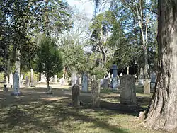 Wintergreen Cemetery |
July 22, 1979 (#79003414) |
E. Greenwood St. 31°57′05″N 90°58′45″W |
Port Gibson |
Former listing
| [3] | Name on the Register | Image | Date listed | Date removed | Location | City or town | Summary |
|---|---|---|---|---|---|---|---|
| 1 | Hollyrood | July 22, 1979 (#79003413) | January 31, 1992 | Old Hwy. 61 S |
Port Gibson | ||
| 2 | Valley of the Moon Bridge | June 8, 2005 (#05000561) | September 28, 2017 | Willows Rd. at its crossing of Bayou Pierre, 2 miles southeast of Willows 32°01′03″N 90°52′37″W |
Port Gibson |
See also
| Wikimedia Commons has media related to National Register of Historic Places in Claiborne County, Mississippi. |
References
- The latitude and longitude information provided in this table was derived originally from the National Register Information System, which has been found to be fairly accurate for about 99% of listings. Some locations in this table may have been corrected to current GPS standards.
- "National Register of Historic Places: Weekly List Actions". National Park Service, United States Department of the Interior. Retrieved on February 5, 2021.
- Numbers represent an alphabetical ordering by significant words. Various colorings, defined here, differentiate National Historic Landmarks and historic districts from other NRHP buildings, structures, sites or objects.
- "National Register Information System". National Register of Historic Places. National Park Service. March 13, 2009.
- The eight-digit number below each date is the number assigned to each location in the National Register Information System database, which can be viewed by clicking the number.
- Old Natchez Trace (No. 132-31) (Alternate names: Path to Choctaw Nation, Chickasaw Trace, Natchez Trace), National Register of Historic Places Inventory Nomination Form for Federal Properties, prepared September 9, 1974; received March 25, 1976; entered November 7, 1976
| Topics | |
|---|---|
| Lists by state |
|
| Lists by insular areas | |
| Lists by associated state | |
| Other areas | |
| Related | |
| |
Municipalities and communities of Claiborne County, Mississippi, United States | ||
|---|---|---|
| City | Map of Mississippi highlighting Claiborne County | |
| CDP | ||
| Unincorporated communities | ||
| Ghost towns | ||
| ||
This article is issued from Wikipedia. The text is licensed under Creative Commons - Attribution - Sharealike. Additional terms may apply for the media files.