National Register of Historic Places listings in Clarke County, Mississippi
This is a list of the National Register of Historic Places listings in Clarke County, Mississippi.
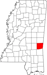
Location of Clarke County in Mississippi
This is intended to be a complete list of the properties and districts on the National Register of Historic Places in Clarke County, Mississippi, United States. Latitude and longitude coordinates are provided for many National Register properties and districts; these locations may be seen together in a map.[1]
There are 51 properties and districts listed on the National Register in the county. Another property was once listed but has been removed.
- This National Park Service list is complete through NPS recent listings posted February 5, 2021.[2]
Current listings
| [3] | Name on the Register[4] | Image | Date listed[5] | Location | City or town | Description |
|---|---|---|---|---|---|---|
| 1 | Adams-Taylor-McRae House | May 22, 1980 (#80002207) |
East of Pachuta 32°01′18″N 88°47′21″W |
Elwood | ||
| 2 | C.V. Akin House | May 20, 1994 (#94000512) |
Southern side of Clarion St., approximately ¼ mile east of U.S. Route 45 31°58′19″N 88°42′54″W |
De Soto | ||
| 3 | Asher's Cabin | May 22, 1980 (#80002234) |
Mississippi Highway 513 32°08′53″N 88°48′09″W |
Stonewall | ||
| 4 | Barbour-Estes House | May 22, 1980 (#80002209) |
River Rd. 32°09′57″N 88°49′26″W |
Enterprise | ||
| 5 | Bradshaw-Booth House | May 22, 1980 (#80002210) |
Stonewall St. 32°09′55″N 88°48′47″W |
Enterprise | ||
| 6 | Brown-Wilson House | May 22, 1980 (#80002211) |
U.S. Highway 11 32°09′56″N 88°50′04″W |
Enterprise | ||
| 7 | Judge John L. Buckley House | May 20, 1994 (#94000513) |
Northern side of Bridge St. at its junction with Hand Ave. 32°10′33″N 88°49′29″W |
Enterprise | ||
| 8 | Carmichael House | May 22, 1980 (#80002204) |
South of De Soto along the Gulf, Mobile and Ohio railroad tracks 31°58′11″N 88°42′52″W |
De Soto | ||
| 9 | Benjamin H. Carter House | 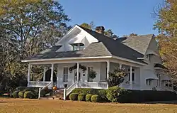 Benjamin H. Carter House |
May 20, 1994 (#94000514) |
210 Ferrill St. 32°02′12″N 88°43′31″W |
Quitman | |
| 10 | Clarke County Courthouse and Confederate Monument | 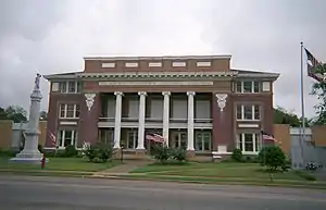 Clarke County Courthouse and Confederate Monument |
May 20, 1994 (#94000511) |
Archusa St. at the head of Main St. 32°02′23″N 88°43′39″W |
Quitman | |
| 11 | Compton-Short House | May 22, 1980 (#80002212) |
Tuscaboma St. 32°10′28″N 88°48′10″W |
Enterprise | ||
| 12 | Cook-Sellers House | May 22, 1980 (#80002205) |
E. Station St. 31°58′24″N 88°42′46″W |
De Soto | ||
| 13 | Covington House | May 22, 1980 (#80002206) |
Northeast of De Soto 31°59′15″N 88°42′25″W |
De Soto | ||
| 14 | Davis House | May 22, 1980 (#80002213) |
River Rd. 32°10′28″N 88°49′26″W |
Enterprise | ||
| 15 | Dearman House | May 22, 1980 (#80002214) |
Bridge St. and River Rd. 32°10′27″N 88°49′26″W |
Enterprise | ||
| 16 | East Enterprise Historic District | May 20, 1994 (#94000510) |
Roughly bounded by S. Stonewall St., Church St., Mississippi Highway 513, and Tuscahoma Rd. 32°10′29″N 88°48′41″W |
Enterprise | ||
| 17 | Enterprise Bridge | November 16, 1988 (#88002402) |
Spans the Chickasawhay River on Bridge St. 32°10′33″N 88°49′11″W |
Enterprise | ||
| 18 | Capt. C.C. Ferrill House | 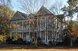 Capt. C.C. Ferrill House |
May 20, 1994 (#94000509) |
118 E. Franklin St. 32°02′09″N 88°43′31″W |
Quitman | |
| 19 | Ford-Williams House | May 22, 1980 (#80002208) |
Mississippi Highway 514 32°11′14″N 88°31′00″W |
Energy | ||
| 20 | Forestdale Plantation | May 22, 1980 (#80002229) |
End of County Road 1222, southwest of Quitman[6] 32°00′43″N 88°49′13″W |
Pachuta | ||
| 21 | Hand House | May 22, 1980 (#80002231) |
North St. 31°51′45″N 88°41′49″W |
Shubuta | ||
| 22 | Highway 11 Bridge over Chunky River |  Highway 11 Bridge over Chunky River |
November 16, 1988 (#88002400) |
Spans the Chunky River on U.S. Route 11 32°11′32″N 88°49′30″W |
Enterprise | |
| 23 | House at 200 East Franklin Street |  House at 200 East Franklin Street |
June 2, 1994 (#94000538) |
200 E. Franklin St. 32°02′10″N 88°43′28″W |
Quitman | |
| 24 | House on Old Mill Creek Road | May 20, 1994 (#94000508) |
Western side of Old Mill Creek Rd., between Old Mill Creek Rd. and U.S. Route 11 32°10′38″N 88°49′44″W |
Enterprise | ||
| 25 | Hunter-Frost House | May 22, 1980 (#80002215) |
River Rd. 32°09′56″N 88°49′25″W |
Enterprise | ||
| 26 | J.K. Kirkland General Merchandise Store | May 20, 1994 (#94000507) |
124 Main St. 32°02′23″N 88°43′46″W |
Quitman | ||
| 27 | Lee-Mitts House | May 22, 1980 (#80002216) |
Stonewall St. 32°10′27″N 88°48′48″W |
Enterprise | ||
| 28 | McCrory-Deas-Buckley House | May 22, 1980 (#80002217) |
Bridge St. 32°10′27″N 88°48′48″W |
Enterprise | ||
| 29 | Dr. McNair House | November 4, 2009 (#94000500) |
116 E. Church St. 32°02′25″N 88°43′37″W |
Quitman | ||
| 30 | McNeill-McGee House | May 22, 1980 (#80002226) |
Northeast of Lake Bounds 31°53′23″N 88°53′23″W |
Lake Bounds | ||
| 31 | Methodist Parsonage House | May 22, 1980 (#80002219) |
A St. 32°09′57″N 88°49′26″W |
Enterprise | ||
| 32 | Noah Moore House | May 20, 1994 (#94000506) |
111 Main St. 32°10′26″N 88°49′32″W |
Enterprise | ||
| 33 | Overseer's House and Outbuildings of Lang Plantation | May 22, 1980 (#80002227) |
Off County Road 610 in Langsdale[6] 31°53′21″N 88°35′11″W |
Langsdale | ||
| 34 | Pilgrim's Rest | May 22, 1980 (#80002220) |
Tuscaboma St. 32°10′29″N 88°48′09″W |
Enterprise | ||
| 35 | Prairie Place | May 22, 1980 (#80002228) |
Off County Road 610 in Langsdale[6] 31°53′21″N 88°35′12″W |
Langsdale | ||
| 36 | Price-Patton-Pettis House | May 22, 1980 (#80002232) |
North and 2nd Sts. 31°51′47″N 88°41′43″W |
Shubuta | ||
| 37 | Quitman Depot |  Quitman Depot |
May 20, 1994 (#94000505) |
Eastern side of the Illinois Central Gulf railroad tracks, near the junction of Main St. and Railroad Ave. 32°02′23″N 88°43′49″W |
Quitman | |
| 38 | Quitman Downtown-Mill Historic District | September 9, 2016 (#16000614) |
Roughly bounded by Long Blvd., Jackson, Franklin & Railroad Aves. 32°02′22″N 88°43′32″W |
Quitman | ||
| 39 | Riverside Plantation | May 22, 1980 (#80002221) |
U.S. Highway 11 32°10′59″N 88°50′03″W |
Enterprise | ||
| 40 | Shubuta Baptist Church | June 24, 1994 (#94000641) |
Eucutta St. at its junction with U.S. Route 45 31°51′37″N 88°42′00″W |
Shubuta | ||
| 41 | Shubuta Bridge | November 16, 1988 (#88002490) |
Spans the Chickasawhay River on a county road, east of Shubuta 31°51′25″N 88°41′12″W |
Shubuta | ||
| 42 | Shubuta Methodist Episcopal Church, South |  Shubuta Methodist Episcopal Church, South |
May 20, 1994 (#94000504) |
Eastern side of High St. (U.S. Route 45) 31°51′33″N 88°41′59″W |
Shubuta | |
| 43 | Smith-McClain-Buckley House | May 22, 1980 (#80002222) |
Stonewall St. 32°09′56″N 88°48′48″W |
Enterprise | ||
| 44 | Stephenson-Allen House | May 22, 1980 (#80002223) |
Bridge St. 32°10′26″N 88°50′02″W |
Enterprise | ||
| 45 | Stonewall Mill Village Historic District | May 20, 1994 (#94000503) |
Roughly the area surrounding Erwin Rd. between Alice and Allen Aves. 32°08′08″N 88°47′21″W |
Stonewall | ||
| 46 | Sumrall-Albritton House | May 22, 1980 (#80002233) |
U.S. Highway 45 31°54′18″N 88°42′31″W |
Shubuta | ||
| 47 | Trotter-Byrd House | May 22, 1980 (#80002230) |
419 E. Franklin St. 32°01′55″N 88°43′31″W |
Quitman | ||
| 48 | Ward House | May 22, 1980 (#80002224) |
3 miles north of Enterprise 32°12′37″N 88°50′05″W |
Enterprise | ||
| 49 | Jim Williams House | May 20, 1994 (#94000502) |
Western side of N. River Rd., near its junction with Mississippi Highway 513 32°10′34″N 88°49′18″W |
Enterprise | ||
| 50 | Woolverton-Boyd House | May 22, 1980 (#80002225) |
Off Mississippi Highway 513 32°09′58″N 88°48′45″W |
Enterprise | ||
| 51 | W.W. Wyatt House | May 20, 1994 (#94000501) |
107 N. River Rd. 32°10′37″N 88°49′18″W |
Enterprise |
Former listing
| [3] | Name on the Register | Image | Date listed | Date removed | Location | City or town | Summary |
|---|---|---|---|---|---|---|---|
| 1 | McGee-Hudson House | 1980 (#80002218) | January 31, 1994 | Tuscaboma Street |
Enterprise |
See also
| Wikimedia Commons has media related to National Register of Historic Places in Clarke County, Mississippi. |
References
- The latitude and longitude information provided in this table was derived originally from the National Register Information System, which has been found to be fairly accurate for about 99% of listings. Some locations in this table may have been corrected to current GPS standards.
- "National Register of Historic Places: Weekly List Actions". National Park Service, United States Department of the Interior. Retrieved on February 5, 2021.
- Numbers represent an alphabetical ordering by significant words. Various colorings, defined here, differentiate National Historic Landmarks and historic districts from other NRHP buildings, structures, sites or objects.
- "National Register Information System". National Register of Historic Places. National Park Service. March 13, 2009.
- The eight-digit number below each date is the number assigned to each location in the National Register Information System database, which can be viewed by clicking the number.
- Location derived from this Clarke County Economic Development District webpage; the NRIS lists the site as "Address unknown at this time"
| Topics | |
|---|---|
| Lists by state |
|
| Lists by insular areas | |
| Lists by associated state | |
| Other areas | |
| Related | |
| |
Municipalities and communities of Clarke County, Mississippi, United States | ||
|---|---|---|
| City | Map of Mississippi highlighting Clarke County | |
| Towns | ||
| Unincorporated communities | ||
| Ghost town | ||
| ||
This article is issued from Wikipedia. The text is licensed under Creative Commons - Attribution - Sharealike. Additional terms may apply for the media files.