National Register of Historic Places listings in Dawson County, Montana
This is a list of the National Register of Historic Places listings in Dawson County, Montana. It is intended to be a complete list of the properties and districts on the National Register of Historic Places in Dawson County, Montana, United States. The locations of National Register properties and districts for which the latitude and longitude coordinates are included below, may be seen in a map.[1]
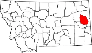
Location of Dawson County in Montana
There are 13 properties and districts listed on the National Register in the county, including 1 National Historic Landmark.
- This National Park Service list is complete through NPS recent listings posted January 29, 2021.[2]
Listings county-wide
| [3] | Name on the Register | Image | Date listed[4] | Location | City or town | Description |
|---|---|---|---|---|---|---|
| 1 | Bad Route Creek Bridge | April 28, 2011 (#11000224) |
Milepost 20 on County Road 261 46°53′23″N 105°00′36″W |
Fallon vicinity | Reinforced Concrete Bridges in Montana, 1900-1958 MPS | |
| 2 | Bell Street Bridge | 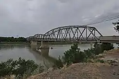 Bell Street Bridge |
February 3, 1988 (#87002517) |
W. Bell St. 47°06′20″N 104°43′09″W |
Glendive | |
| 3 | Blackstock Residence | 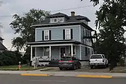 Blackstock Residence |
February 3, 1988 (#87002515) |
217 W. Towne 47°06′21″N 104°42′51″W |
Glendive | |
| 4 | First Methodist Episcopal Church and Parsonage | 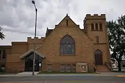 First Methodist Episcopal Church and Parsonage |
February 3, 1988 (#87002513) |
209 N. Kendrick 47°06′22″N 104°42′49″W |
Glendive | |
| 5 | Glendive City Water Filtration Plant | 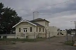 Glendive City Water Filtration Plant |
February 3, 1988 (#87002512) |
420 W. Bell St. 47°06′21″N 104°43′02″W |
Glendive | |
| 6 | Glendive Heat, Light and Power Company Power Plant | 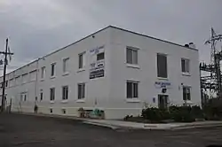 Glendive Heat, Light and Power Company Power Plant |
February 3, 1988 (#87002511) |
Clough St. 47°06′18″N 104°43′02″W |
Glendive | |
| 7 | Hagen Site | 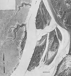 Hagen Site |
October 15, 1966 (#66000432) |
Address Restricted |
Glendive | |
| 8 | Charles Krug House | 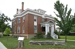 Charles Krug House |
June 3, 1976 (#76001122) |
103 N. Douglas St. 47°06′21″N 104°42′59″W |
Glendive | |
| 9 | McCone Residence | February 3, 1988 (#87002509) |
218 W. Towne 47°06′23″N 104°42′50″W |
Glendive | Probably demolished. | |
| 10 | Merrill Avenue Historic District | 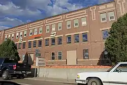 Merrill Avenue Historic District |
February 3, 1988 (#87002508) |
Western side of Merrill Ave. between S. Douglas St. and W. Clement St. and the eastern side of Merrill Ave. between W. Towne and W. Clement 47°06′18″N 104°42′45″W |
Glendive | |
| 11 | Northern Pacific Railroad Settling Tanks |  Northern Pacific Railroad Settling Tanks |
February 3, 1988 (#87002507) |
Towne and Clough Sts. 47°06′25″N 104°43′02″W |
Glendive | |
| 12 | Sacred Heart Church | 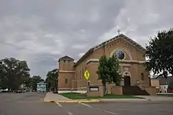 Sacred Heart Church |
February 3, 1988 (#87002504) |
316 W. Benham 47°06′28″N 104°42′51″W |
Glendive | |
| 13 | US Post Office | 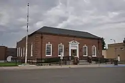 US Post Office |
February 3, 1988 (#87002503) |
221 N. Kendrick 47°06′24″N 104°42′47″W |
Glendive |
See also
| Wikimedia Commons has media related to National Register of Historic Places in Dawson County, Montana. |
References
- The latitude and longitude information provided in this table was derived originally from the National Register Information System, which has been found to be fairly accurate for about 99% of listings. Some locations in this table may have been corrected to current GPS standards.
- "National Register of Historic Places: Weekly List Actions". National Park Service, United States Department of the Interior. Retrieved on January 29, 2021.
- Numbers represent an alphabetical ordering by significant words. Various colorings, defined here, differentiate National Historic Landmarks and historic districts from other NRHP buildings, structures, sites or objects.
- The eight-digit number below each date is the number assigned to each location in the National Register Information System database, which can be viewed by clicking the number.
| Topics | |
|---|---|
| Lists by state |
|
| Lists by insular areas | |
| Lists by associated state | |
| Other areas | |
| Related | |
| |
Municipalities and communities of Dawson County, Montana, United States | ||
|---|---|---|
| City | Dawson County map | |
| Town | ||
| CDP | ||
| Unincorporated communities | ||
| ||
This article is issued from Wikipedia. The text is licensed under Creative Commons - Attribution - Sharealike. Additional terms may apply for the media files.