National Register of Historic Places listings in Dodge County, Nebraska
This is a list of the National Register of Historic Places listings in Dodge County, Nebraska.
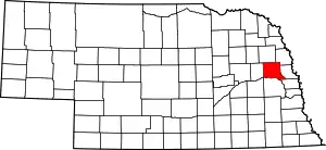
Location of Dodge County in Nebraska
This is intended to be a complete list of the properties and districts on the National Register of Historic Places in Dodge County, Nebraska, United States. The locations of National Register properties and districts for which the latitude and longitude coordinates are included below, may be seen in a map.[1]
There are 22 properties and districts listed on the National Register in the county.
- This National Park Service list is complete through NPS recent listings posted January 29, 2021.[2]
Current listings
| [3] | Name on the Register | Image | Date listed[4] | Location | City or town | Description |
|---|---|---|---|---|---|---|
| 1 | Barnard Park Historic District | 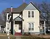 Barnard Park Historic District |
July 12, 1990 (#90001053) |
Bounded by 4th, 8th, and Union Sts. and Platte Ave. 41°26′04″N 96°29′23″W |
Fremont | |
| 2 | Samuel Bullock House | 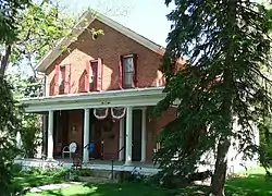 Samuel Bullock House |
September 12, 1985 (#85002147) |
508 W. Military Ave. 41°26′10″N 96°30′08″W |
Fremont | |
| 3 | Dodge County Courthouse | Dodge County Courthouse |
January 10, 1990 (#89002208) |
435 N. Park Ave. 41°26′00″N 96°29′51″W |
Fremont | |
| 4 | Charles T. Durkee House | Charles T. Durkee House |
August 10, 2011 (#11000528) |
1125 N. Broad St. 41°26′24″N 96°29′54″W |
Fremont | |
| 5 | Fremont Historic Commercial District | 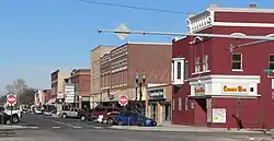 Fremont Historic Commercial District |
February 17, 1995 (#95000091) |
Roughly bounded by 3rd, Military, Park, and D Sts. 41°26′01″N 96°29′47″W |
Fremont | |
| 6 | Fremont Municipal Auditorium | Fremont Municipal Auditorium |
July 11, 2002 (#02000773) |
925 Broad St. 41°26′17″N 96°29′54″W |
Fremont | |
| 7 | Fremont Municipal Power Plant and Pumping Station | Fremont Municipal Power Plant and Pumping Station |
July 11, 2002 (#02000772) |
8th St. and Park Ave. 41°26′11″N 96°29′47″W |
Fremont | |
| 8 | Harder Hotel | _from_E_1.JPG.webp) Harder Hotel |
November 27, 1989 (#89002046) |
503 Main St. 41°40′00″N 96°39′57″W |
Scribner | |
| 9 | Hooper Historic District | 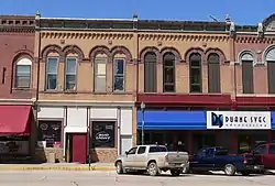 Hooper Historic District |
May 8, 1980 (#80002445) |
Main, Elk, Fulton, and Myrtle Sts. 41°36′41″N 96°32′51″W |
Hooper | |
| 10 | Christopher Knoell Farmstead | 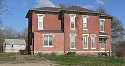 Christopher Knoell Farmstead |
January 13, 1983 (#83001089) |
Northwest of Fremont 41°29′32″N 96°32′53″W |
Fremont | |
| 11 | Love-Larson Opera House | 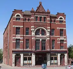 Love-Larson Opera House |
September 10, 1974 (#74001107) |
543-545 Broad St. 41°26′04″N 96°29′55″W |
Fremont | |
| 12 | J.D. McDonald House | _from_SW_1.JPG.webp) J.D. McDonald House |
December 10, 1980 (#80002444) |
310 E. Military Ave. 41°26′10″N 96°29′39″W |
Fremont | |
| 13 | North Bend Carnegie Library | 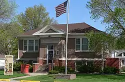 North Bend Carnegie Library |
September 3, 1981 (#81000371) |
140 E. 8th St. 41°27′50″N 96°46′44″W |
North Bend | |
| 14 | North Broad Street Residential Historic District | 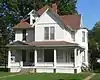 North Broad Street Residential Historic District |
March 17, 2015 (#15000088) |
Along Broad St. 41°26′26″N 96°29′53″W |
Fremont | |
| 15 | Nye House | _from_E_1.JPG.webp) Nye House |
November 23, 1977 (#77000827) |
1643 N. Nye Ave. 41°26′42″N 96°30′09″W |
Fremont | |
| 16 | Old Fremont Post Office | 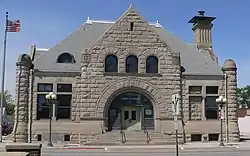 Old Fremont Post Office |
February 29, 1996 (#96000223) |
605 N. Broad St. 41°26′06″N 96°29′55″W |
Fremont | |
| 17 | Osterman and Tremaine Building | 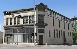 Osterman and Tremaine Building |
May 23, 1978 (#78001695) |
455 N. Broad St. 41°26′01″N 96°29′55″W |
Fremont | Also known as Ideal Steam Laundry Building |
| 18 | Schneider's Opera House | 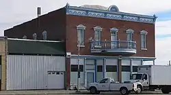 Schneider's Opera House |
September 28, 1988 (#88000939) |
104 Ash 41°42′10″N 96°47′18″W |
Snyder | |
| 19 | R.B. Schneider House | _from_S_1.JPG.webp) R.B. Schneider House |
July 15, 1982 (#82003186) |
234 W. 10th St. 41°26′20″N 96°29′57″W |
Fremont | |
| 20 | Scribner Town Hall |  Scribner Town Hall |
August 30, 2010 (#10000608) |
West terminus of Howard St. at 3rd St. 41°39′59″N 96°40′01″W |
Scribner | |
| 21 | George and Nancy Turner House | George and Nancy Turner House |
January 11, 1996 (#95001502) |
78 S. C St. 41°25′45″N 96°29′37″W |
Fremont | |
| 22 | Frank Uehling Barn | 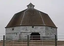 Frank Uehling Barn |
August 1, 1985 (#85001666) |
Off U.S. Route 77 41°44′16″N 96°30′04″W |
Uehling |
See also
| Wikimedia Commons has media related to National Register of Historic Places in Dodge County, Nebraska. |
References
- The latitude and longitude information provided in this table was derived originally from the National Register Information System, which has been found to be fairly accurate for about 99% of listings. Some locations in this table may have been corrected to current GPS standards.
- "National Register of Historic Places: Weekly List Actions". National Park Service, United States Department of the Interior. Retrieved on January 29, 2021.
- Numbers represent an alphabetical ordering by significant words. Various colorings, defined here, differentiate National Historic Landmarks and historic districts from other NRHP buildings, structures, sites or objects.
- The eight-digit number below each date is the number assigned to each location in the National Register Information System database, which can be viewed by clicking the number.
| Topics | |
|---|---|
| Lists by state |
|
| Lists by insular areas | |
| Lists by associated state | |
| Other areas | |
| Related | |
| |
Municipalities and communities of Dodge County, Nebraska, United States | ||
|---|---|---|
| Cities | Map of Nebraska highlighting Dodge County | |
| Villages | ||
| Townships | ||
| CDPs | ||
| Unincorporated communities | ||
| Ghost towns | ||
| Footnotes | ‡This populated place also has portions in an adjacent county or counties | |
| ||
This article is issued from Wikipedia. The text is licensed under Creative Commons - Attribution - Sharealike. Additional terms may apply for the media files.