National Register of Historic Places listings in Fergus County, Montana
This is a list of the National Register of Historic Places listings in Fergus County, Montana. It is intended to be a complete list of the properties and districts on the National Register of Historic Places in Fergus County, Montana, United States. The locations of National Register properties and districts for which the latitude and longitude coordinates are included below, may be seen in a map.[1]
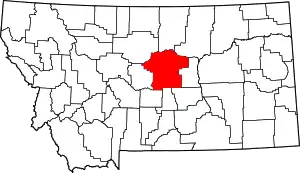
Location of Fergus County in Montana
There are 44 properties and districts listed on the National Register in the county.
- This National Park Service list is complete through NPS recent listings posted January 29, 2021.[2]
Listings county-wide
| [3] | Name on the Register | Image | Date listed[4] | Location | City or town | Description |
|---|---|---|---|---|---|---|
| 1 | Anderson House | 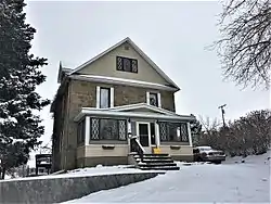 Anderson House |
January 27, 1993 (#92001770) |
1015 W. Watson 47°03′32″N 109°25′54″W |
Lewistown | |
| 2 | Ayers House | January 10, 1986 (#86000061) |
316 8th Ave., S. 47°04′06″N 109°25′39″W |
Lewistown | ||
| 3 | Bright House |  Bright House |
January 27, 1993 (#92001766) |
707 W. Boulevard 47°03′50″N 109°25′56″W |
Lewistown | |
| 4 | Clark–Cardwell House | 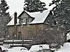 Clark–Cardwell House |
January 10, 1986 (#86000063) |
523 W. Watson 47°03′40″N 109°25′34″W |
Lewistown | |
| 5 | Culver Studio |  Culver Studio |
August 11, 1980 (#80002412) |
212 5th Ave. 47°03′49″N 109°25′43″W |
Lewistown | |
| 6 | Draft Horse Barn, Fergus County Fairgrounds | December 14, 2017 (#100001895) |
1000 US 191 47°05′01″N 109°25′47″W |
Lewistown | ||
| 6 | Fergus County High School | _-_Fergus_County%252C_Montana.png.webp) Fergus County High School |
June 27, 1985 (#85001409) |
412 6th Ave., S. 47°03′37″N 109°25′33″W |
Lewistown | |
| 7 | Fergus County Improvement Corporation Dormitory | February 1, 1980 (#80002413) |
216 7th St., S. 47°03′37″N 109°25′41″W |
Lewistown | ||
| 8 | First Presbyterian Church | _-_Fergus_County%252C_Montana.png.webp) First Presbyterian Church |
January 10, 1986 (#86000065) |
215 5th Ave., S. 47°03′45″N 109°25′30″W |
Lewistown | |
| 9 | Gamble–Robinson Company Warehouse |  Gamble–Robinson Company Warehouse |
April 17, 2017 (#100000888) |
302 E. Main St. 47°04′07″N 109°25′18″W |
Lewistown | |
| 10 | Frank Hagadone Homestead | 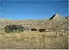 Frank Hagadone Homestead |
January 29, 2009 (#08001384) |
20 miles (32 km) north of Winifred, near Mile 97 on the Missouri River[5] 47°43′45″N 109°28′35″W |
Winifred | |
| 11 | Abraham and Mary Walton Hogeland House | May 24, 2007 (#07000465) |
620 W. Montana St. 47°03′55″N 109°25′57″W |
Lewistown | ||
| 12 | House at 301 Eighth Avenue, South | January 10, 1986 (#86000066) |
301 8th Ave., S. 47°03′23″N 109°25′39″W |
Lewistown | ||
| 13 | House at 324 W. Corcoran | January 27, 1993 (#92001773) |
324 W. Corcoran 47°04′07″N 109°25′52″W |
Lewistown | ||
| 14 | House at 618 West Janeaux | 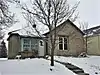 House at 618 West Janeaux |
January 10, 1986 (#86000062) |
618 W. Janeaux 47°03′44″N 109°25′35″W |
Lewistown | |
| 15 | House at 805 W. Watson | 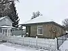 House at 805 W. Watson |
January 27, 1993 (#92001767) |
805 W. Watson 47°03′38″N 109°25′46″W |
Lewistown | |
| 16 | House at 809 W. Watson |  House at 809 W. Watson |
January 27, 1993 (#92001768) |
809 W. Watson 47°03′38″N 109°25′45″W |
Lewistown | |
| 17 | House at 813 W. Watson | 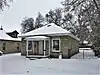 House at 813 W. Watson |
January 27, 1993 (#92001769) |
813 W. Watson 47°03′39″N 109°25′45″W |
Lewistown | |
| 18 | Huntoon Residence | June 27, 1985 (#85001408) |
722 W. Water 47°03′24″N 109°25′38″W |
Lewistown | ||
| 19 | Judith Landing Historic District |  Judith Landing Historic District |
December 6, 1975 (#75001081) |
Missouri River at Montana Highway 236 in Upper Missouri River Breaks National Monument 47°44′18″N 109°37′33″W |
Winifred | Extends into Chouteau County. Boundary increase on 2014-04-11. |
| 20 | Judith Place Historic District |  Judith Place Historic District |
May 4, 1988 (#88000465) |
Roughly bounded by Main St., the alley between Hawthorne and Ridgelawn Sts., Washington St., and Oullette St. 47°04′16″N 109°25′01″W |
Lewistown | |
| 21 | Lewis House |  Lewis House |
January 27, 1993 (#92001765) |
702 W. Boulevard 47°03′52″N 109°25′56″W |
Lewistown | |
| 22 | Lewistown Carnegie Library | 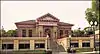 Lewistown Carnegie Library |
August 11, 1980 (#80002411) |
701 W. Main St. 47°03′41″N 109°25′47″W |
Lewistown | |
| 23 | Lewistown Central Business Historic District | 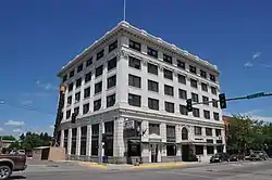 Lewistown Central Business Historic District |
June 27, 1985 (#85001405) |
Roughly bounded by Washington St., 1st Ave., Janeaux St., and 8th Ave. 47°03′53″N 109°25′44″W |
Lewistown | |
| 24 | Lewistown Courthouse Historic District | 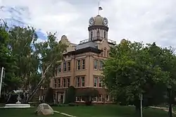 Lewistown Courthouse Historic District |
June 27, 1985 (#85001406) |
Roughly bounded by Washington St., 6th Ave., Main and Broadway Sts. 47°03′42″N 109°25′50″W |
Lewistown | |
| 25 | Lewistown Mercantile Company |  Lewistown Mercantile Company |
February 3, 1986 (#86000064) |
220 E. Main 47°04′03″N 109°25′20″W |
Lewistown | |
| 26 | Lewistown Satellite Airfield Historic District | March 8, 2000 (#00000162) |
Aztec and Horizon Drives 47°02′50″N 109°27′30″W |
Lewistown | Surviving buildings of WW2 airfield at Lewistown Municipal Airport. Boundary increase approved May 1, 2018. | |
| 27 | Lewistown Silk Stocking District | 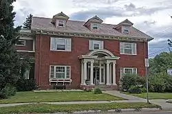 Lewistown Silk Stocking District |
June 27, 1985 (#85001407) |
Roughly bounded by 2nd Ave., Boulevard and Washington Sts. and 3rd Ave. 47°03′58″N 109°25′36″W |
Lewistown | |
| 28 | Masonic Temple | 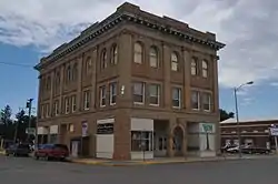 Masonic Temple |
July 3, 1979 (#79001401) |
322 W. Broadway St. 47°03′53″N 109°25′35″W |
Lewistown | |
| 29 | Mill House | January 27, 1993 (#92001764) |
Montana Highway 466 4.5 miles (7.2 km) southeast of Lewistown, along Spring Creek 47°01′10″N 109°21′26″W |
Lewistown | ||
| 30 | N-Bar Ranch | July 9, 1991 (#91000881) |
15 miles (24 km) southwest of Grass Range 46°51′16″N 108°56′19″W |
Grass Range | ||
| 31 | Naylor Brothers Ranch Historic District | December 30, 2008 (#08001261) |
503 E. Dry Creek Rd.[6] 46°48′37″N 109°44′49″W |
Buffalo | ||
| 32 | Gus Nelson Homestead | March 21, 2011 (#11000093) |
Missouri River, River Mile 129.4-131.1; west side of river 47°45′07″N 108°55′59″W |
Cow Island vicinity | ||
| 33 | Reed and Bowles Trading Post |  Reed and Bowles Trading Post |
August 5, 2010 (#10000520) |
Joyland Rd.[7] 47°05′16″N 109°27′25″W |
Lewistown vicinity | |
| 34 | Reed's Fort Post Office | August 10, 2010 (#10000545) |
.1 miles (0.16 km) southwest from the junction of Brassey St. and 6th Ave. on Casino Creek Dr.[8] 47°03′30″N 109°25′27″W |
Lewistown | ||
| 35 | Fred Robinson Bridge | March 26, 2012 (#12000171) |
Milepost 88, US 191, 51 miles (82 km) north of Lewistown 47°37′51″N 108°41′06″W |
Lewistown vicinity | Montana's Steel Stringer and Steel Girder Bridges Multiple Property Submission; extends into Phillips County | |
| 36 | Rocky Point | May 21, 1975 (#75001082) |
30 miles (48 km) south of Landusky in the Charles M. Russell National Wildlife Refuge 47°36′23″N 108°26′41″W |
Landusky | ||
| 37 | St. James Episcopal Church and Parish House |  St. James Episcopal Church and Parish House |
November 16, 1978 (#78001683) |
502 W. Montana St. 47°03′55″N 109°25′51″W |
Lewistown | |
| 38 | St. Joseph's Hospital | 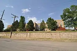 St. Joseph's Hospital |
September 13, 1978 (#78001684) |
Fountain Terrace Dr. and S. High St. 47°04′06″N 109°25′06″W |
Lewistown | Now converted to housing. |
| 39 | St. Leo's Catholic Church | _-_Fergus_County%252C_Montana.png.webp) St. Leo's Catholic Church |
May 6, 1982 (#82003163) |
124 W. Broadway 47°03′58″N 109°25′29″W |
Lewistown | |
| 40 | St. Wenceslaus Catholic Church |  St. Wenceslaus Catholic Church |
May 19, 2014 (#14000221) |
7724 Danvers Road 47°13′28″N 109°43′03″W |
Danvers | |
| 41 | Schroeder Hospital | January 27, 1993 (#92001771) |
502 5th Ave., S. 47°03′45″N 109°25′30″W |
Lewistown | ||
| 42 | Stafford's Grocery | 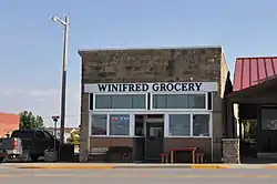 Stafford's Grocery |
April 5, 2016 (#16000141) |
201 Main St. 47°33′34″N 109°22′35″W |
Winifred | |
| 43 | U.S. Post Office and Federal Building – Lewistown | 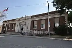 U.S. Post Office and Federal Building – Lewistown |
March 14, 1986 (#86000684) |
204 3rd Ave., N. 47°03′55″N 109°25′34″W |
Lewistown |
See also
| Wikimedia Commons has media related to National Register of Historic Places in Fergus County, Montana. |
References
- The latitude and longitude information provided in this table was derived originally from the National Register Information System, which has been found to be fairly accurate for about 99% of listings. Some locations in this table may have been corrected to current GPS standards.
- "National Register of Historic Places: Weekly List Actions". National Park Service, United States Department of the Interior. Retrieved on January 29, 2021.
- Numbers represent an alphabetical ordering by significant words. Various colorings, defined here, differentiate National Historic Landmarks and historic districts from other NRHP buildings, structures, sites or objects.
- The eight-digit number below each date is the number assigned to each location in the National Register Information System database, which can be viewed by clicking the number.
- geocode codes derived from Google Earth and description of hike to Hagdone site on Friends of the Missouri Breaks Monument website Archived 2011-07-16 at the Wayback Machine
- Geocode coords derived from Google Maps and description of location in NRHP Registration Form Archived 2008-11-07 at the Wayback Machine.
- Geocode coordinates derived from NRHP Registration Form Archived 2014-10-21 at the Wayback Machine
- Geocode coordinates derived from NRHP Registration Form Archived 2010-07-16 at the Wayback Machine
| Topics | |
|---|---|
| Lists by state |
|
| Lists by insular areas | |
| Lists by associated state | |
| Other areas | |
| Related | |
| |
Municipalities and communities of Fergus County, Montana, United States | ||
|---|---|---|
| City | Fergus County map | |
| Towns | ||
| CDP | ||
| Other unincorporated communities | ||
| Ghost town | ||
| Indian reservation | ||
| Footnotes | ‡This populated place also has portions in an adjacent county or counties | |
| ||
This article is issued from Wikipedia. The text is licensed under Creative Commons - Attribution - Sharealike. Additional terms may apply for the media files.