National Register of Historic Places listings in Granite County, Montana
This is a list of the National Register of Historic Places listings in Granite County, Montana. It is intended to be a complete list of the properties and districts on the National Register of Historic Places in Granite County, Montana, United States. The locations of National Register properties and districts for which the latitude and longitude coordinates are included below, may be seen in a map.[1]
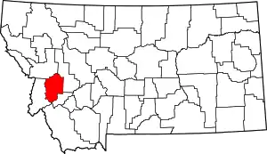
Location of Granite County in Montana
There are 12 properties and districts listed on the National Register in the county.
- This National Park Service list is complete through NPS recent listings posted January 29, 2021.[2]
Current listings
| [3] | Name on the Register | Image | Date listed[4] | Location | City or town | Description |
|---|---|---|---|---|---|---|
| 1 | Anderson Lumber Company | December 3, 1986 (#86002790) |
Roughly bounded by Brown, 1st, and Holland Sts. 46°20′02″N 113°18′01″W |
Philipsburg | ||
| 2 | M.E. Doe House | 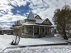 M.E. Doe House |
December 3, 1986 (#86002788) |
Dearborn and Montgomery Sts. 46°19′44″N 113°17′34″W |
Philipsburg | |
| 3 | Garnet Historic District | 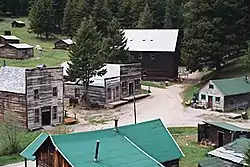 Garnet Historic District |
August 12, 2010 (#10000547) |
11 miles north of the junction of Interstate 90 and Bear Gulch Rd. in the Bureau of Land Management's Garnet Resource Area 46°49′31″N 113°20′20″W |
Garnet | |
| 4 | Granite County Jail | 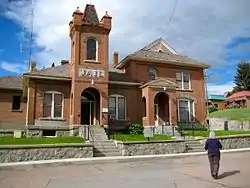 Granite County Jail |
August 27, 1980 (#80002420) |
Kearney St. 46°20′02″N 113°17′31″W |
Philipsburg | |
| 5 | Miners Union Hall | 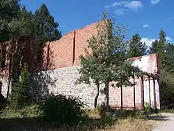 Miners Union Hall |
December 19, 1974 (#74001096) |
East of Philipsburg in Deerlodge National Forest 46°19′04″N 113°14′55″W |
Philipsburg | |
| 6 | Moose Lake Camp Historic District | December 26, 2017 (#100001931) |
Moose Lake Residential Site, Lots 4 & 5, Block B 46°03′09″N 113°31′44″W |
Philipsburg vicinity | ||
| 7 | Morgan-Case Homestead | February 9, 2005 (#05000011) |
Dirt road south of the confluence of Hogback Creek and Rock Creek 46°26′48″N 113°41′35″W |
Philipsburg | ||
| 8 | Philipsburg Grade School | 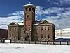 Philipsburg Grade School |
December 3, 1986 (#86002789) |
West of Schnepel St. 46°19′44″N 113°17′43″W |
Philipsburg | |
| 9 | Philipsburg Historic District | 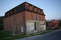 Philipsburg Historic District |
September 30, 1986 (#86002791) |
Roughly bounded by Gamma St. and Cleveland Ave., Montgomery, Madison, and Duffy, and Cedar and McDonald Sts. 46°20′03″N 113°17′38″W |
Philipsburg | |
| 10 | Ringeling House | December 3, 1986 (#86002787) |
Caledonian Mining Claim, east of the Doe and Morse Addition 46°19′40″N 113°17′21″W |
Philipsburg | ||
| 11 | Rock Creek Guard Station (24GN165) | July 13, 1982 (#82003172) |
West of Philipsburg on Montana Secondary Highway 348 and the Rock Creek Rd. 46°25′20″N 113°42′56″W |
Philipsburg | ||
| 12 | Superintendent's House | December 17, 1974 (#74001097) |
East of Philipsburg in Deerlodge National Forest 46°19′01″N 113°14′45″W |
Philipsburg |
See also
| Wikimedia Commons has media related to National Register of Historic Places in Granite County, Montana. |
References
- The latitude and longitude information provided in this table was derived originally from the National Register Information System, which has been found to be fairly accurate for about 99% of listings. Some locations in this table may have been corrected to current GPS standards.
- "National Register of Historic Places: Weekly List Actions". National Park Service, United States Department of the Interior. Retrieved on January 29, 2021.
- Numbers represent an alphabetical ordering by significant words. Various colorings, defined here, differentiate National Historic Landmarks and historic districts from other NRHP buildings, structures, sites or objects.
- The eight-digit number below each date is the number assigned to each location in the National Register Information System database, which can be viewed by clicking the number.
| Topics | |
|---|---|
| Lists by state |
|
| Lists by insular areas | |
| Lists by associated state | |
| Other areas | |
| Related | |
| |
Municipalities and communities of Granite County, Montana, United States | ||
|---|---|---|
| Towns | Granite County map | |
| CDP | ||
| Unincorporated community | ||
| Ghost towns | ||
| ||
This article is issued from Wikipedia. The text is licensed under Creative Commons - Attribution - Sharealike. Additional terms may apply for the media files.