National Register of Historic Places listings in Greene County, Illinois
This is a list of the National Register of Historic Places listings in Greene County, Illinois.
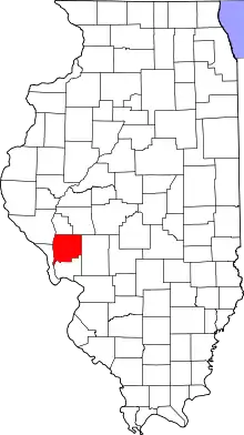
Location of Greene County in Illinois
This is intended to be a complete list of the properties and districts on the National Register of Historic Places in Greene County, Illinois, United States. Latitude and longitude coordinates are provided for many National Register properties and districts; these locations may be seen together in a map.[1]
There are 12 properties and districts listed on the National Register in the county.
- This National Park Service list is complete through NPS recent listings posted February 5, 2021.[2]
Current listings
| [3] | Name on the Register | Image | Date listed[4] | Location | City or town | Description |
|---|---|---|---|---|---|---|
| 1 | Black Homestead Farm | 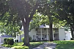 Black Homestead Farm |
May 24, 2005 (#05000110) |
RR 3 39°17′37″N 90°26′45″W |
Carrollton | |
| 2 | Carrollton Courthouse Square Historic District | 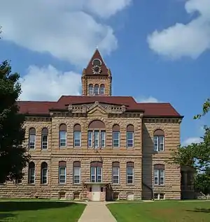 Carrollton Courthouse Square Historic District |
August 1, 1985 (#85001667) |
Roughly bounded by S. Main, W. 5th, N. Main and W. 6th Sts. 39°18′06″N 90°24′35″W |
Carrollton | |
| 3 | James John Eldred House | 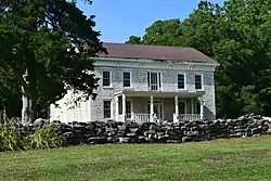 James John Eldred House |
June 25, 1999 (#99000732) |
Bluffdale Township Rd., E of IL 100 39°18′29″N 90°32′55″W |
Eldred | |
| 4 | Greene County Almshouse | 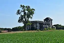 Greene County Almshouse |
May 17, 1991 (#91000568) |
Twp. Rd. TR156A NE of Carrollton 39°19′47″N 90°21′53″W |
Carrollton | |
| 5 | Hodges House | 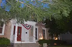 Hodges House |
November 3, 1980 (#80001364) |
532 N. Main St. 39°18′08″N 90°24′32″W |
Carrollton | |
| 6 | Hotel Roodhouse | 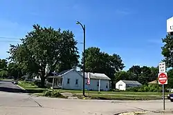 Hotel Roodhouse |
November 7, 1995 (#95001238) |
303 Morse St. 39°28′56″N 90°22′22″W |
Roodhouse | |
| 7 | Koster Site |  Koster Site |
June 19, 1972 (#72000460) |
200 yards (180 m) east of the Eldred-Hillview road, 5.5 miles (8.9 km) south of Eldred[5] 39°12′33″N 90°32′57″W |
Eldred | |
| 8 | Mound House Site | September 1, 1978 (#78001148) |
Eastern bank of the Illinois River, ½ mile west of the end of 600E[6] 39°29′36″N 90°35′01″W |
Hillview | ||
| 9 | Henry T. Rainey Farm | 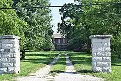 Henry T. Rainey Farm |
May 12, 1987 (#87000682) |
RR 1, N side of IL 108 39°18′12″N 90°23′14″W |
Carrollton | |
| 10 | Virginia Tillery Round Barn | 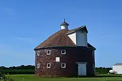 Virginia Tillery Round Barn |
August 26, 1982 (#82002536) |
W of White Hall on CR 738 39°26′26″N 90°26′37″W |
White Hall | |
| 11 | White Hall Foundry | 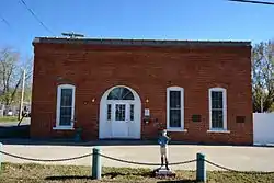 White Hall Foundry |
May 28, 1980 (#80001365) |
102 S. Jacksonville St. 39°26′05″N 90°24′30″W |
White Hall | |
| 12 | White Hall Historic District | 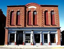 White Hall Historic District |
May 20, 1987 (#86003145) |
Roughly bounded by Bridgeport, Jacksonville, Ayers, and Main Sts.; also 120 S. Jacksonville St. 39°26′12″N 90°24′11″W |
White Hall | 120 Jacksonville represents a boundary increase of February 11, 1993 |
See also
| Wikimedia Commons has media related to National Register of Historic Places in Greene County, Illinois. |
References
- The latitude and longitude information provided in this table was derived originally from the National Register Information System, which has been found to be fairly accurate for about 99% of listings. Some locations in this table may have been corrected to current GPS standards.
- "National Register of Historic Places: Weekly List Actions". National Park Service, United States Department of the Interior. Retrieved on February 5, 2021.
- Numbers represent an alphabetical ordering by significant words. Various colorings, defined here, differentiate National Historic Landmarks and historic districts from other NRHP buildings, structures, sites or objects.
- The eight-digit number below each date is the number assigned to each location in the National Register Information System database, which can be viewed by clicking the number.
- Struever, Stuart. National Register of Historic Places Inventory - Nomination Form: The Koster Site. National Park Service, 1971-11-04.
- Maruszak, Kathleen. National Register of Historic Places Inventory/Nomination: Mound House Site. National Park Service, 1977-07, 4.
| Topics | |
|---|---|
| Lists by state |
|
| Lists by insular areas | |
| Lists by associated state | |
| Other areas | |
| Related | |
| |
Municipalities and communities of Greene County, Illinois, United States | ||
|---|---|---|
| Cities | Map of Illinois highlighting Greene County | |
| Villages | ||
| Townships | ||
| Unincorporated communities | ||
| ||
This article is issued from Wikipedia. The text is licensed under Creative Commons - Attribution - Sharealike. Additional terms may apply for the media files.