National Register of Historic Places listings in Holmes County, Mississippi
This is a list of the National Register of Historic Places listings in Holmes County, Mississippi.
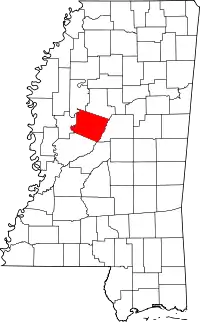
Location of Holmes County in Mississippi
This is intended to be a complete list of the properties and districts on the National Register of Historic Places in Holmes County, Mississippi, United States. Latitude and longitude coordinates are provided for many National Register properties and districts; these locations may be seen together in a map.[1]
There are 17 properties and districts listed on the National Register in the county.
- This National Park Service list is complete through NPS recent listings posted February 5, 2021.[2]
Current listings
| [3] | Name on the Register[4] | Image | Date listed[5] | Location | City or town | Description |
|---|---|---|---|---|---|---|
| 1 | Acona Church, Cemetery, and School | .jpg.webp) Acona Church, Cemetery, and School |
March 20, 2002 (#02000210) |
Mississippi Highway 17 33°16′05″N 90°01′08″W |
Lexington | |
| 2 | Mollie Clark House | September 15, 1980 (#80002249) |
2221 Yazoo St. 32°53′04″N 89°58′31″W |
Pickens | ||
| 3 | Clifton Plantation House | October 3, 1985 (#85002721) |
Off Mississippi Highway 12 33°07′55″N 90°11′05″W |
Howard | ||
| 4 | Joe Cowsert Place Site (22HO507) | February 27, 1987 (#87000227) |
Address Restricted |
Goodman | ||
| 5 | Durant Illinois Central Railroad Depot | January 19, 2016 (#15000988) |
436 E. Mulberry St. 33°04′27″N 89°51′11″W |
Durant | ||
| 6 | Eureka Masonic College | 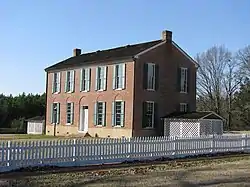 Eureka Masonic College |
November 10, 1970 (#70000318) |
On Mississippi Highway 17 32°58′25″N 89°59′11″W |
Richland | |
| 7 | French Site (22HO565) | November 6, 1986 (#86002328) |
Address Restricted |
Cruger | Extends into Carroll County | |
| 8 | Holmes County Courthouse Complex |  Holmes County Courthouse Complex |
November 10, 1994 (#94001301) |
Court Sq. 33°06′45″N 90°03′10″W |
Lexington | |
| 9 | Holmes County State Park | .jpg.webp) Holmes County State Park |
July 25, 1997 (#97000769) |
Between Interstate 55 and U.S. Highway 51, 1 mile south of Durant 33°01′48″N 89°55′27″W |
Durant | |
| 10 | Frances Lee Mound Group (22HO654) | April 6, 1988 (#88000236) |
Address Restricted |
Tchula | ||
| 11 | Lexington Historic District | July 19, 2001 (#01000754) |
Roughly Courthouse Sq., along Yazoo, Vine, Tchula, Boulevard, Springs, Race Sts., and Old Tchula Rd. 33°06′53″N 90°02′59″W |
Lexington | ||
| 12 | Gov. Edmund F. Noel House | November 18, 1999 (#99001360) |
315 North St. 33°06′57″N 90°03′00″W |
Lexington | ||
| 13 | Old Hoover Place Site (22HO502) | March 1, 1987 (#87000132) |
Address Restricted |
Pickens | ||
| 14 | Oswego Site (22HO658) | April 6, 1988 (#88000235) |
Address Restricted |
Tchula | ||
| 15 | Providence Mound (22HO609) | March 1, 1987 (#87000136) |
Address Restricted |
Lexington | ||
| 16 | Tye House | December 18, 1979 (#79001315) |
2440 N. 1st St. 32°53′14″N 89°58′42″W |
Pickens | ||
| 17 | West Historic District | September 14, 1993 (#93000646) |
Roughly bounded by Emory St., Anderson Ave., and Cross St., and the Illinois Central railroad tracks 33°11′55″N 89°46′48″W |
West |
See also
| Wikimedia Commons has media related to National Register of Historic Places in Holmes County, Mississippi. |
References
- The latitude and longitude information provided in this table was derived originally from the National Register Information System, which has been found to be fairly accurate for about 99% of listings. Some locations in this table may have been corrected to current GPS standards.
- "National Register of Historic Places: Weekly List Actions". National Park Service, United States Department of the Interior. Retrieved on February 5, 2021.
- Numbers represent an alphabetical ordering by significant words. Various colorings, defined here, differentiate National Historic Landmarks and historic districts from other NRHP buildings, structures, sites or objects.
- "National Register Information System". National Register of Historic Places. National Park Service. March 13, 2009.
- The eight-digit number below each date is the number assigned to each location in the National Register Information System database, which can be viewed by clicking the number.
| Topics | |
|---|---|
| Lists by state |
|
| Lists by insular areas | |
| Lists by associated state | |
| Other areas | |
| Related | |
| |
Municipalities and communities of Holmes County, Mississippi, United States | ||
|---|---|---|
| Cities | Map of Mississippi highlighting Holmes County | |
| Towns | ||
| Unincorporated communities | ||
| Ghost town | ||
| ||
This article is issued from Wikipedia. The text is licensed under Creative Commons - Attribution - Sharealike. Additional terms may apply for the media files.