National Register of Historic Places listings in Jackson County, Illinois
This is a list of the National Register of Historic Places listings in Jackson County, Illinois.
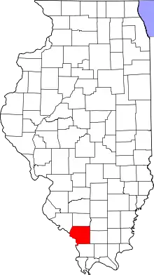
Location of Jackson County in Illinois
This is intended to be a complete list of the properties and districts on the National Register of Historic Places in Jackson County, Illinois, United States. Latitude and longitude coordinates are provided for many National Register properties and districts; these locations may be seen together in a map.[1]
There are 17 properties and districts listed on the National Register in the county. Another property was once listed but has been removed.
- This National Park Service list is complete through NPS recent listings posted February 5, 2021.[2]
Current listings
| [3] | Name on the Register | Image | Date listed[4] | Location | City or town | Description |
|---|---|---|---|---|---|---|
| 1 | Cleiman Mound and Village Site |  Cleiman Mound and Village Site |
October 18, 1977 (#77000487) |
Northeast of the junction of Big Lake and Thomas Town Rds.[5] 37°47′12″N 89°32′05″W |
Gorham | |
| 2 | R. Buckminster & Anne Hewlett Fuller Dome Home |  R. Buckminster & Anne Hewlett Fuller Dome Home |
February 9, 2006 (#06000012) |
407 S. Forest Ave. 37°43′23″N 89°13′31″W |
Carbondale | |
| 3 | Giant City Stone Fort Site |  Giant City Stone Fort Site |
August 9, 2002 (#02000848) |
Stone Fort Rd. 37°37′24″N 89°11′50″W |
Makanda | |
| 4 | Grand Tower Mining, Manufacturing and Transportation Company Site |  Grand Tower Mining, Manufacturing and Transportation Company Site |
April 13, 1979 (#79000839) |
Devil's Backbone Park 37°38′06″N 89°30′30″W |
Grand Tower | |
| 5 | Grange Hall | 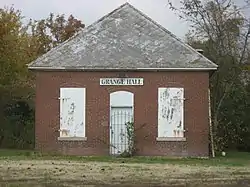 Grange Hall |
May 4, 1990 (#90000722) |
Illinois Routes 13/127 south of Beaucoup Creek 37°49′10″N 89°19′19″W |
Murphysboro | |
| 6 | Robert W. Hamilton House | 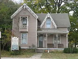 Robert W. Hamilton House |
March 5, 1982 (#82002540) |
203 S. 13th St. 37°45′47″N 89°20′13″W |
Murphysboro | |
| 7 | Cornelius Hennessy Building | 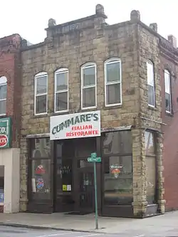 Cornelius Hennessy Building |
November 8, 2000 (#00001331) |
1023 Chestnut St. 37°45′48″N 89°20′07″W |
Murphysboro | |
| 8 | William H. Hull House | 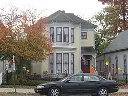 William H. Hull House |
February 1, 2006 (#05001602) |
1517 Walnut St. 37°45′51″N 89°20′25″W |
Murphysboro | |
| 9 | Illinois Central Railroad Passenger Depot |  Illinois Central Railroad Passenger Depot |
May 9, 2002 (#02000457) |
111 S. Illinois Ave. 37°43′36″N 89°12′59″W |
Carbondale | |
| 10 | Jackson County Courthouse |  Jackson County Courthouse |
December 29, 2015 (#15000931) |
1001 Walnut St. 37°45′51″N 89°20′06″W |
Murphysboro | |
| 11 | Liberty Theater |  Liberty Theater |
June 13, 2012 (#12000322) |
1333 Walnut St. 37°45′51″N 89°20′16″W |
Murphysboro | |
| 12 | Mobile and Ohio Railroad Depot |  Mobile and Ohio Railroad Depot |
November 13, 1984 (#84000317) |
1701 Walnut St. 37°45′51″N 89°20′31″W |
Murphysboro | |
| 13 | Murphysboro Elks Lodge | 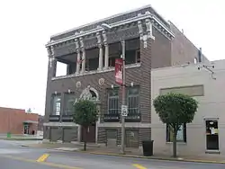 Murphysboro Elks Lodge |
November 15, 2005 (#05001255) |
1329 Walnut St. 37°45′51″N 89°20′15″W |
Murphysboro | |
| 14 | Reef House |  Reef House |
November 14, 1985 (#85002839) |
411 S. Poplar St. 37°43′23″N 89°13′17″W |
Carbondale | |
| 15 | Riverside Park Bandshell |  Riverside Park Bandshell |
June 6, 2012 (#12000323) |
22nd and Commercial Sts. 37°45′22″N 89°21′25″W |
Murphysboro | |
| 16 | West Walnut Street Historic District |  West Walnut Street Historic District |
May 2, 1975 (#75000664) |
Roughly bounded by W. Elm, S. Poplar, W. Main, and S. Forest Sts. 37°43′32″N 89°13′28″W |
Carbondale | |
| 17 | Woodlawn Cemetery |  Woodlawn Cemetery |
December 19, 1985 (#85003219) |
405 E. Main St. 37°43′38″N 89°12′39″W |
Carbondale |
Former listing
| [3] | Name on the Register | Image | Date listed | Date removed | Location | City or town | Summary |
|---|---|---|---|---|---|---|---|
| 1 | Dr. Frank M. Agnew House | September 13, 1978 (#78001152) | September 15, 1987 | Southeast of Makanda on Illinois Route 12 |
Makanda |
See also
| Wikimedia Commons has media related to National Register of Historic Places in Jackson County, Illinois. |
References
- The latitude and longitude information provided in this table was derived originally from the National Register Information System, which has been found to be fairly accurate for about 99% of listings. Some locations in this table may have been corrected to current GPS standards.
- "National Register of Historic Places: Weekly List Actions". National Park Service, United States Department of the Interior. Retrieved on February 5, 2021.
- Numbers represent an alphabetical ordering by significant words. Various colorings, defined here, differentiate National Historic Landmarks and historic districts from other NRHP buildings, structures, sites or objects.
- The eight-digit number below each date is the number assigned to each location in the National Register Information System database, which can be viewed by clicking the number.
- Pulcher, Ronald E. National Register of Historic Places Inventory/Nomination: Cleiman Mound and Village Site. National Park Service, 1975-07-30, 4.
| Topics | |
|---|---|
| Lists by state |
|
| Lists by insular areas | |
| Lists by associated state | |
| Other areas | |
| Related | |
| |
Municipalities and communities of Jackson County, Illinois, United States | ||
|---|---|---|
| Cities | Map of Illinois highlighting Jackson County | |
| Villages | ||
| Townships | ||
| CDP | ||
| Other unincorporated communities | ||
| Ghost town | ||
| Footnotes | ‡This populated place also has portions in an adjacent county or counties | |
| ||
This article is issued from Wikipedia. The text is licensed under Creative Commons - Attribution - Sharealike. Additional terms may apply for the media files.