National Register of Historic Places listings in Jefferson County, Mississippi
This is a list of the National Register of Historic Places listings in Jefferson County, Mississippi.
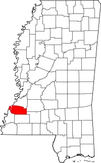
Location of Jefferson County in Mississippi
This is intended to be a complete list of the properties and districts on the National Register of Historic Places in Jefferson County, Mississippi, United States. Latitude and longitude coordinates are provided for many National Register properties and districts; these locations may be seen together in a map.[1]
There are 24 properties and districts listed on the National Register in the county.
- This National Park Service list is complete through NPS recent listings posted January 29, 2021.[2]
Current listings
| [3] | Name on the Register[4] | Image | Date listed[5] | Location | City or town | Description |
|---|---|---|---|---|---|---|
| 1 | Blantonia Plantation House | March 4, 1993 (#93000145) |
3 miles east of Red Lick on an unmarked road off Mississippi Highway 552 31°48′06″N 90°55′55″W |
Lorman | ||
| 2 | Cedar Grove Place | March 28, 1979 (#79001317) |
Mississippi Highway 553 31°42′36″N 91°14′39″W |
Church Hill | ||
| 3 | China Grove | April 3, 1980 (#80002254) |
West of Lorman off U.S. Route 61 31°49′43″N 91°03′50″W |
Lorman | ||
| 4 | Christ Church | 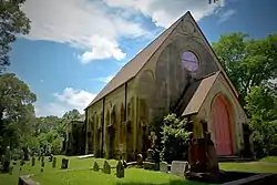 Christ Church |
May 6, 1977 (#77000790) |
Mississippi Highway 553 31°42′54″N 91°14′17″W |
Church Hill | |
| 5 | Church Hill Rural Historic District | September 8, 2000 (#00001054) |
Mississippi Highway 553 and Church Hill Rd., 1 mile south of Christ Episcopal Church 31°42′27″N 91°14′37″W |
Natchez | ||
| 6 | Coon Box Fork Bridge | May 23, 1979 (#79003429) |
Coon Box Rd. 31°47′25″N 91°05′37″W |
Coon Box | Destroyed in 2015. | |
| 7 | Hays House | March 10, 2009 (#09000111) |
18800 U.S. Route 61, S. 31°49′28″N 91°02′54″W |
Lorman | ||
| 8 | Hughes-Clark House | August 3, 1987 (#87001260) |
221 Poindexter St. 31°42′40″N 91°03′36″W |
Fayette | ||
| 9 | Jefferson Chapel A.M.E. Church and Cemetery | January 24, 2019 (#100003343) |
291 Chapel Hill Rd. 31°40′45″N 91°14′04″W |
Natchez | ||
| 10 | Laurietta | November 24, 1980 (#80002253) |
South of Fayette off Mississippi Highway 33 31°40′45″N 91°04′56″W |
Fayette | ||
| 11 | Mud Island Creek Complex (22JE508 and 22JE513) | June 29, 1989 (#89000447) |
Address Restricted |
Lorman | ||
| 12 | Oak Grove | February 22, 1979 (#79001318) |
Mississippi Highway 553 31°42′42″N 91°14′22″W |
Church Hill | ||
| 13 | Old Hill Place Bridge | May 23, 1979 (#79003430) |
Hill Rd. 31°40′09″N 91°10′52″W |
Fayette | ||
| 14 | Pecan Grove | March 13, 1980 (#80002252) |
North of Church Hill off Mississippi Highway 553 31°44′06″N 91°13′51″W |
Church Hill | ||
| 15 | Poplar Hill Grade School | March 10, 2010 (#10000064) |
3080 Poplar Hill Rd. 31°45′50″N 91°05′37″W |
Fayette | ||
| 16 | Richland | July 5, 1984 (#84002227) |
Off Mississippi Highway 553 31°45′07″N 91°11′54″W |
Church Hill | ||
| 17 | Rodney Center Historic District | 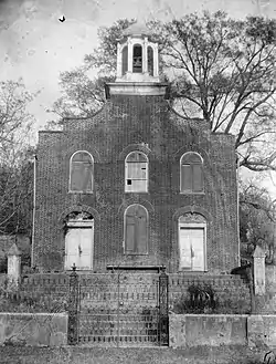 Rodney Center Historic District |
August 29, 1980 (#80002255) |
Northwest of Lorman 31°51′40″N 91°11′52″W |
Lorman | |
| 18 | Rodney Presbyterian Church | 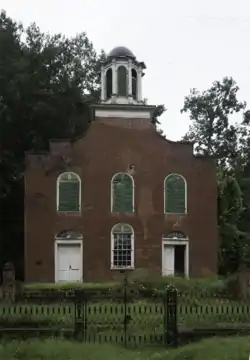 Rodney Presbyterian Church |
February 6, 1973 (#73001018) |
West of Alcorn in the village of Rodney 31°51′46″N 91°11′59″W |
Alcorn | |
| 19 | Rosswood | December 8, 1978 (#78001606) |
East of Lorman on Mississippi Highway 552 31°49′08″N 91°00′43″W |
Lorman | ||
| 20 | Springfield Plantation | 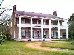 Springfield Plantation |
November 23, 1971 (#71000454) |
8 miles west of Fayette off Mississippi Highway 553 31°44′46″N 91°11′35″W |
Fayette | Where Andrew Jackson married Rachel Donelson Robards. |
| 21 | Union Church Presbyterian Church | 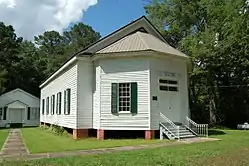 Union Church Presbyterian Church |
July 18, 1979 (#79001322) |
Mississippi Highway 550 31°40′58″N 90°47′26″W |
Union Church | |
| 22 | Woodland Plantation | November 27, 1978 (#78001605) |
South of Church Hill on Mississippi Highway 553 31°40′00″N 91°13′54″W |
Church Hill | ||
| 23 | Wyolah Plantation | May 30, 1985 (#85001168) |
Off Mississippi Highway 553 31°42′10″N 91°14′47″W |
Church Hill | ||
| 24 | Youngblood Bridge | May 23, 1979 (#79003428) |
Youngblood Rd. 31°38′00″N 90°48′51″W |
Union Church |
See also
| Wikimedia Commons has media related to National Register of Historic Places in Jefferson County, Mississippi. |
References
- The latitude and longitude information provided in this table was derived originally from the National Register Information System, which has been found to be fairly accurate for about 99% of listings. Some locations in this table may have been corrected to current GPS standards.
- "National Register of Historic Places: Weekly List Actions". National Park Service, United States Department of the Interior. Retrieved on January 29, 2021.
- Numbers represent an alphabetical ordering by significant words. Various colorings, defined here, differentiate National Historic Landmarks and historic districts from other NRHP buildings, structures, sites or objects.
- "National Register Information System". National Register of Historic Places. National Park Service. March 13, 2009.
- The eight-digit number below each date is the number assigned to each location in the National Register Information System database, which can be viewed by clicking the number.
| Topics | |
|---|---|
| Lists by state |
|
| Lists by insular areas | |
| Lists by associated state | |
| Other areas | |
| Related | |
| |
Municipalities and communities of Jefferson County, Mississippi, United States | ||
|---|---|---|
| City | Map of Mississippi highlighting Jefferson County | |
| Unincorporated communities | ||
| Ghost towns | ||
| ||
This article is issued from Wikipedia. The text is licensed under Creative Commons - Attribution - Sharealike. Additional terms may apply for the media files.