National Register of Historic Places listings in Keith County, Nebraska
This is a list of the National Register of Historic Places listings in Keith County, Nebraska. It is intended to be a complete list of the properties and districts on the National Register of Historic Places in Keith County, Nebraska, United States. The locations of National Register properties and districts for which the latitude and longitude coordinates are included below, may be seen in a map.[1]
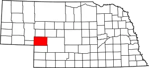
Location of Keith County in Nebraska
There are 13 properties and districts listed on the National Register in the county.
- This National Park Service list is complete through NPS recent listings posted January 29, 2021.[2]
Current listings
| [3] | Name on the Register | Image | Date listed[4] | Location | City or town | Description |
|---|---|---|---|---|---|---|
| 1 | Alkali Station | November 14, 2016 (#16000776) |
Address Restricted |
Roscoe | ||
| 2 | Archeological Site 25KH67 | December 4, 2001 (#01001279) |
Address Restricted |
Paxton | ||
| 3 | Archeological Site 25KH68 | December 4, 2001 (#01001278) |
Address Restricted |
Brule | ||
| 4 | Beauvais' Ranche Archeological Site | February 20, 1975 (#75001096) |
Address Restricted |
Brule | ||
| 5 | Leonidas A. Brandhoefer Mansion | 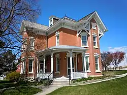 Leonidas A. Brandhoefer Mansion |
October 3, 1973 (#73001065) |
10th and Spruce Sts. 41°08′01″N 101°43′14″W |
Ogallala | |
| 6 | California Hill | _ruts_1.JPG.webp) California Hill |
July 15, 1974 (#74001126) |
West of Brule 41°06′02″N 101°58′54″W |
Brule | |
| 7 | Diamond Springs Stage Station Site | 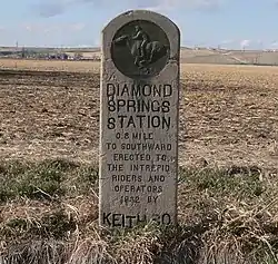 Diamond Springs Stage Station Site |
October 15, 1970 (#70000371) |
1 mile west of the Brule exit on Interstate 80 41°04′47″N 101°54′19″W |
Brule | |
| 8 | Front Street | 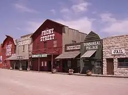 Front Street |
January 6, 2015 (#14001128) |
519 E. 1st St. 41°07′31″N 101°42′50″W |
Ogallala | |
| 9 | Dr. Burdette and Myrna Gainsforth House | 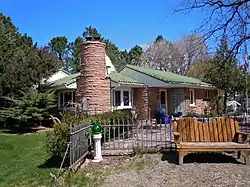 Dr. Burdette and Myrna Gainsforth House |
December 5, 2002 (#02001476) |
1300 East A St. 41°08′13″N 101°43′09″W |
Ogallala | |
| 10 | Keystone Community Church | 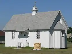 Keystone Community Church |
January 1, 1979 (#79001447) |
McGinley St. 41°13′03″N 101°35′03″W |
Keystone | |
| 11 | Roscoe State Aid Bridge |  Roscoe State Aid Bridge |
June 29, 1992 (#92000709) |
State Link 51B over the South Platte River, 0.5 miles southeast of Roscoe 41°07′33″N 101°34′35″W |
Roscoe | |
| 12 | Standard Oil Red Crown Service Station | 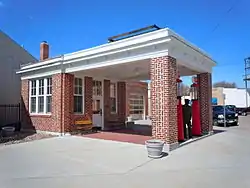 Standard Oil Red Crown Service Station |
August 20, 2004 (#04000897) |
220 N. Spruce St. 41°07′34″N 101°43′09″W |
Ogallala | |
| 13 | US Post Office-Ogallala | 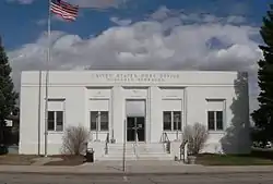 US Post Office-Ogallala |
May 11, 1992 (#92000481) |
301 N. Spruce St. 41°07′37″N 101°43′09″W |
Ogallala | One of 12 Nebraska post offices featuring a Section of Fine Arts mural, "Longhorns" (1938) by Frank Mechau.[5] |
Former listing
| [3] | Name on the Register | Image | Date listed | Date removed | Location | City or town | Summary |
|---|---|---|---|---|---|---|---|
| 1 | Welsch Motor Court-Erin Plaza Motor Court | 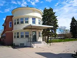 Welsch Motor Court-Erin Plaza Motor Court |
November 16, 2005 (#05001295) | September 4, 2013 | 311 E. 1st St. 41°07′30″N 101°42′58″W |
Ogallala |
See also
| Wikimedia Commons has media related to National Register of Historic Places in Keith County, Nebraska. |
References
- The latitude and longitude information provided in this table was derived originally from the National Register Information System, which has been found to be fairly accurate for about 99% of listings. Some locations in this table may have been corrected to current GPS standards.
- "National Register of Historic Places: Weekly List Actions". National Park Service, United States Department of the Interior. Retrieved on January 29, 2021.
- Numbers represent an alphabetical ordering by significant words. Various colorings, defined here, differentiate National Historic Landmarks and historic districts from other NRHP buildings, structures, sites or objects.
- The eight-digit number below each date is the number assigned to each location in the National Register Information System database, which can be viewed by clicking the number.
- Ahlgren, Carol (August 1991). "National Register of Historic Places Multiple Property Documentation Form: Nebraska Post Offices Which Contain Section Artwork (1938-1942)" (PDF). Retrieved 2013-01-28. Cite journal requires
|journal=(help)
| Topics | |
|---|---|
| Lists by state |
|
| Lists by insular areas | |
| Lists by associated state | |
| Other areas | |
| Related | |
| |
This article is issued from Wikipedia. The text is licensed under Creative Commons - Attribution - Sharealike. Additional terms may apply for the media files.