National Register of Historic Places listings in Lake County, California
This is a list of the National Register of Historic Places listings in Lake County, California.
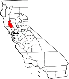
Location of Lake County in California
This is intended to be a complete list of the properties and districts on the National Register of Historic Places in Lake County, California, United States. Latitude and longitude coordinates are provided for many National Register properties and districts; these locations may be seen together in a Google map.[1]
There are 7 properties and districts listed on the National Register in the county, including 1 National Historic Landmark.
- This National Park Service list is complete through NPS recent listings posted January 29, 2021.[2]
Current listings
| [3] | Name on the Register[4] | Image | Date listed[5] | Location | City or town | Description |
|---|---|---|---|---|---|---|
| 1 | Anderson Marsh Archeological District | August 24, 1978 (#78000676) |
Both banks of Cache Creek between Clear Lake and State Route 53[6] 38°55′49″N 122°37′45″W |
Lower Lake | One of prehistoric California's most densely populated areas, with over 40 identified archaeological sites ranging from 10,000 years ago to the early 20th century.[7] | |
| 2 | Archeological Site No. Ca-Lak-711 | May 25, 1979 (#79000479) |
Address Restricted |
Anderson Springs | ||
| 3 | Borax Lake-Hodges Archeological Site | 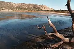 Borax Lake-Hodges Archeological Site |
October 3, 1991 (#91001424) |
Address Restricted |
Clearlake | |
| 4 | Cache Creek Archeological District | December 30, 1997 (#95001130) |
Address Restricted |
Lower Lake | ||
| 6 | Lakeport Carnegie Library | 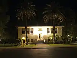 Lakeport Carnegie Library |
April 10, 2008 (#08000261) |
200 Park St. 39°02′36″N 122°54′51″W |
Lakeport | |
| 5 | Old Lake County Courthouse | 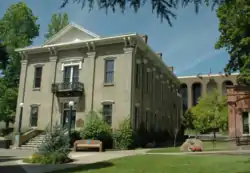 Old Lake County Courthouse |
October 28, 1970 (#70000134) |
255 N. Main St. 39°02′34″N 122°54′55″W |
Lakeport | |
| 7 | Patwin Indian Site | February 23, 1972 (#72000227) |
Address Restricted |
Clearlake Oaks |
See also
| Wikimedia Commons has media related to National Register of Historic Places in Lake County, California. |
References
- The latitude and longitude information provided in this table was derived originally from the National Register Information System, which has been found to be fairly accurate for about 99% of listings. Some locations in this table may have been corrected to current GPS standards.
- "National Register of Historic Places: Weekly List Actions". National Park Service, United States Department of the Interior. Retrieved on January 29, 2021.
- Numbers represent an alphabetical ordering by significant words. Various colorings, defined here, differentiate National Historic Landmarks and historic districts from other NRHP buildings, structures, sites or objects.
- "National Register Information System". National Register of Historic Places. National Park Service. July 9, 2010.
- The eight-digit number below each date is the number assigned to each location in the National Register Information System database, which can be viewed by clicking the number.
- Location given in "Anderson Marsh State Historic Park General Plan" (PDF). California State Parks. June 1989: 38. Retrieved 2015-01-25. Cite journal requires
|journal=(help). NRIS gives location as "Address Restricted." - "Anderson Marsh State Historic Park General Plan" (PDF). California State Parks. June 1989. Retrieved 2015-01-25. Cite journal requires
|journal=(help)
| Topics | |
|---|---|
| Lists by state |
|
| Lists by insular areas | |
| Lists by associated state | |
| Other areas | |
| Related | |
| |
Municipalities and communities of Lake County, California, United States | ||
|---|---|---|
| Cities | Lake County map | |
| CDPs | ||
| Unincorporated communities |
| |
| Indian reservations | ||
| Former settlements | ||
| ||
This article is issued from Wikipedia. The text is licensed under Creative Commons - Attribution - Sharealike. Additional terms may apply for the media files.