National Register of Historic Places listings in Lawrence County, Mississippi
This is a list of the National Register of Historic Places listings in Lawrence County, Mississippi.
Location of Lawrence County in Mississippi
This is intended to be a complete list of the properties and districts on the National Register of Historic Places in Lawrence County, Mississippi, United States. Latitude and longitude coordinates are provided for many National Register properties and districts; these locations may be seen together in a map.[1]
There are 31 properties and districts listed on the National Register in the county.
- This National Park Service list is complete through NPS recent listings posted January 29, 2021.[2]
Current listings
| [3] | Name on the Register[4] | Image | Date listed[5] | Location | City or town | Description |
|---|---|---|---|---|---|---|
| 1 | Armstrong-Lee House | September 29, 1980 (#80002262) |
Mississippi Highway 43 31°30′26″N 90°01′57″W |
Monticello | ||
| 2 | Bahala Creek Bridge | 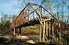 Bahala Creek Bridge |
November 16, 1988 (#88002417) |
Spans Bahala Creek on a county road, southwest of Oma 31°42′17″N 90°12′00″W |
Oma | |
| 3 | Boyd-Cothern House | September 29, 1980 (#80002258) |
West of Jayess 31°21′34″N 90°13′29″W |
Jayess | ||
| 4 | Buckley House | September 29, 1980 (#80002267) |
West of New Hebron 31°44′09″N 90°00′13″W |
New Hebron | ||
| 5 | Bush House | September 29, 1980 (#80002268) |
East of New Hebron on Mississippi Highway 42 31°43′36″N 89°58′49″W |
New Hebron | ||
| 6 | Cannon House | September 29, 1980 (#80002263) |
Mississippi Highway 43 31°30′51″N 90°02′09″W |
Monticello | ||
| 7 | Crane-Mason House | September 29, 1980 (#80002264) |
Southwest of Monticello 31°29′09″N 90°14′24″W |
Monticello | ||
| 8 | Douglas House | September 29, 1980 (#80002275) |
East of Sontag 31°38′53″N 90°10′30″W |
Sontag | ||
| 9 | Fox House | September 29, 1980 (#80002277) |
Northeast of Wanilla 31°39′14″N 90°07′34″W |
Wanilla | ||
| 10 | George Mound (22LW591) | March 1, 1987 (#87000138) |
Address Restricted |
Oma | ||
| 11 | Gunnell House | September 29, 1980 (#80002259) |
West of Topeka 31°25′35″N 90°14′25″W |
Jayess | ||
| 12 | Hilliard House | 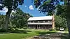 Hilliard House |
September 29, 1980 (#80002278) |
Northeast of Wanilla 31°39′55″N 90°07′23″W |
Wanilla | |
| 13 | Johnson-White House | September 29, 1980 (#80002276) |
East of Sontag 31°38′52″N 90°11′06″W |
Sontag | ||
| 14 | Knapp-Stephens House | September 29, 1980 (#80002269) |
Southwest of New Hebron 31°39′02″N 90°01′28″W |
New Hebron | ||
| 15 | Lawrence County Courthouse |  Lawrence County Courthouse |
March 4, 1993 (#93000146) |
Northern side of Broad St. between Jefferson and Washington Sts. 31°33′14″N 90°06′17″W |
Monticello | |
| 16 | Longino House |  Longino House |
August 21, 1972 (#72000697) |
Caswell St. 31°33′13″N 90°06′10″W |
Monticello | |
| 17 | Lowe-Steen Site (22LW511) | March 1, 1987 (#87000134) |
Address Restricted |
Monticello | ||
| 18 | Mill Creek Site | June 9, 1978 (#78001609) |
Address Restricted |
Monticello | ||
| 19 | Monticello Consolidated School | July 9, 1991 (#91000879) |
125 E. Broad St. 31°33′14″N 90°06′29″W |
Monticello | ||
| 20 | New Orleans Great Northern Railroad Depot | 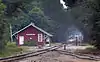 New Orleans Great Northern Railroad Depot |
October 31, 1995 (#95001193) |
Bounded by U.S. Highway 84 and the former Gulf, Mobile and Ohio railroad tracks 31°33′19″N 90°06′45″W |
Monticello | |
| 21 | Newsom-Lane House | September 29, 1980 (#80002270) |
Mississippi Highway 43 31°43′15″N 89°59′01″W |
New Hebron | ||
| 22 | Newsom-Smith House | September 29, 1980 (#80002271) |
Mississippi Highway 43 31°44′26″N 89°58′42″W |
New Hebron | ||
| 23 | Price-Stephens House | September 29, 1980 (#80002272) |
Mississippi Highway 43 31°40′01″N 90°03′28″W |
New Hebron | ||
| 24 | River Road | March 11, 2011 (#11000108) |
Between Mississippi Highway 43 and Conerly Rd. 31°28′19″N 90°01′46″W |
Oak Vale vicinity | ||
| 25 | Robbins House | September 29, 1980 (#80002260) |
East of Topeka 31°24′51″N 90°06′15″W |
Jayess | ||
| 26 | Rogers House | September 29, 1980 (#80002274) |
South of Silver Creek 31°32′47″N 90°00′05″W |
Silver Creek | ||
| 27 | A.L. Smith House | September 29, 1980 (#80002265) |
North of Monticello on Mississippi Highway 27 31°35′42″N 90°06′08″W |
Monticello | ||
| 28 | Stringer House | September 29, 1980 (#80002273) |
Southwest of New Hebron 31°41′47″N 90°02′53″W |
New Hebron | ||
| 29 | June and Nora Thompson House | July 27, 2005 (#05000739) |
Sutton Rd., 0.3 miles (0.48 km) north of its junction with Crooked Creek Rd. 31°43′37″N 90°01′15″W |
New Hebron | ||
| 30 | Tynes House | September 29, 1980 (#80002261) |
East of Topeka 31°25′00″N 90°10′03″W |
Jayess | ||
| 31 | Wilson House | September 29, 1980 (#80002266) |
Southwest of Monticello 31°29′16″N 90°13′56″W |
Monticello |
See also
| Wikimedia Commons has media related to National Register of Historic Places in Lawrence County, Mississippi. |
References
- The latitude and longitude information provided in this table was derived originally from the National Register Information System, which has been found to be fairly accurate for about 99% of listings. Some locations in this table may have been corrected to current GPS standards.
- "National Register of Historic Places: Weekly List Actions". National Park Service, United States Department of the Interior. Retrieved on January 29, 2021.
- Numbers represent an alphabetical ordering by significant words. Various colorings, defined here, differentiate National Historic Landmarks and historic districts from other NRHP buildings, structures, sites or objects.
- "National Register Information System". National Register of Historic Places. National Park Service. March 13, 2009.
- The eight-digit number below each date is the number assigned to each location in the National Register Information System database, which can be viewed by clicking the number.
| Topics | |
|---|---|
| Lists by state |
|
| Lists by insular areas | |
| Lists by associated state | |
| Other areas | |
| Related | |
| |
Municipalities and communities of Lawrence County, Mississippi, United States | ||
|---|---|---|
| Towns | Map of Mississippi highlighting Lawrence County | |
| Unincorporated communities | ||
| Footnotes | ‡This community also has portions in adjacent county or counties | |
| ||
This article is issued from Wikipedia. The text is licensed under Creative Commons - Attribution - Sharealike. Additional terms may apply for the media files.