National Register of Historic Places listings in Leflore County, Mississippi
This is a list of the National Register of Historic Places listings in Leflore County, Mississippi.
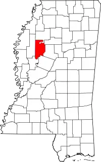
Location of Leflore County in Mississippi
This is intended to be a complete list of the properties and districts on the National Register of Historic Places in Leflore County, Mississippi, United States. Latitude and longitude coordinates are provided for many National Register properties and districts; these locations may be seen together in a map.[1]
There are 38 properties and districts listed on the National Register in the county.
- This National Park Service list is complete through NPS recent listings posted January 29, 2021.[2]
Current listings
| [3] | Name on the Register[4] | Image | Date listed[5] | Location | City or town | Description |
|---|---|---|---|---|---|---|
| 1 | Black Site | November 21, 1978 (#78001612) |
Address Restricted |
Greenwood | ||
| 2 | Black Site | January 11, 1991 (#90002107) |
Address Restricted |
Sidon | ||
| 3 | Boulevard Subdivision Historic District | March 2, 1986 (#86000521) |
Roughly bounded by Jeff Davis Ave., Poplar St., President Ave., and Grand Boulevard 33°31′50″N 90°11′16″W |
Greenwood | ||
| 4 | Building at 308 Lamar Street | 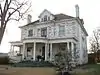 Building at 308 Lamar Street |
November 4, 1985 (#85003456) |
308 Lamar St. 33°31′11″N 90°10′40″W |
Greenwood | |
| 5 | Building at 312 George Street | November 4, 1985 (#85003454) |
312 George St. 33°31′09″N 90°10′43″W |
Greenwood | ||
| 6 | Building at 710 South Boulevard | November 4, 1985 (#85003455) |
710 South Boulevard 33°30′48″N 90°11′12″W |
Greenwood | ||
| 7 | Central Commercial and Railroad Historic District | November 4, 1985 (#85003463) |
Roughly bounded by Washington, Main, and Lamar Sts., Ave. F, Wardaman and Johnson Sts., and Cotton and Fulton Sts. 33°31′02″N 90°10′43″W |
Greenwood | ||
| 8 | Cotton Row Historic District | 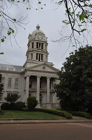 Cotton Row Historic District |
May 15, 1980 (#80002279) |
Cotton, Front, Fulton, Howard, Main, and Market Sts. 33°31′14″N 90°10′59″W |
Greenwood | |
| 9 | Downtown Greenwood Historic District | January 7, 2020 (#100004502) |
Roughly bounded by Front St., River Rd., Lamar, St., McLemore St., Pelican St., Avenue F, Henry St., West Johnson St., Vardaman St., & Dewey St. 33°31′06″N 90°11′00″W |
Greenwood | ||
| 10 | Falls Site (22LF507) | May 1, 1986 (#86000922) |
Northeastern quarter of the northwestern quarter of Section 17, Township 22 North, Range 1 West[6]:56 33°46′54″N 90°19′20″W |
Minter City | ||
| 11 | First Methodist Church of Greenwood |  First Methodist Church of Greenwood |
November 4, 1985 (#85003457) |
310 W. Washington St. 33°31′09″N 90°11′04″W |
Greenwood | |
| 12 | Fort Leflore | April 4, 1979 (#79001327) |
North of Greenwood off Mississippi Highway 7 33°33′06″N 90°10′26″W |
Greenwood | ||
| 13 | Fort Pemberton Site | June 19, 1973 (#73001020) |
West of Greenwood off U.S. Route 49, E. 33°31′45″N 90°14′07″W |
Greenwood | ||
| 14 | Four Corners Historic District | 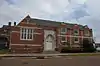 Four Corners Historic District |
February 14, 1985 (#85000282) |
Washington and Henderson Sts. 33°31′07″N 90°11′09″W |
Greenwood | |
| 15 | Greenwood High School | November 4, 1985 (#85003458) |
400 Cotton St. 33°31′11″N 90°10′40″W |
Greenwood | ||
| 16 | Greyhound Lines Station | July 8, 2010 (#10000439) |
325 Main St. 33°31′10″N 90°10′52″W |
Greenwood | ||
| 17 | Itta Bena Historic District | September 30, 2009 (#09000785) |
Roughly bounded by Cemetery St. to the north, Lake Shore Dr. to the east, Lake Side St. to the south, and Dewey St. to the west 33°29′42″N 90°19′11″W |
Itta Bena | ||
| 18 | Keesler Bridge |  Keesler Bridge |
November 16, 1988 (#88002489) |
Spans the Yazoo River at Fulton St. 33°31′18″N 90°11′03″W |
Greenwood | |
| 19 | Lane's Chapel Site | May 4, 1976 (#76001099) |
Address Restricted |
Money | ||
| 20 | Marclare | November 25, 1980 (#80002280) |
River Rd. 33°31′19″N 90°13′17″W |
Greenwood | ||
| 21 | McLean Site (22LF513) | April 6, 1988 (#88000230) |
Southwestern quarter of the northwestern quarter of Section 33, Township 19 North, Range 1 West[6]:57 33°28′18″N 90°18′46″W |
Itta Bena | ||
| 22 | Murphey Site | November 10, 1993 (#93001151) |
Address Restricted |
Itta Bena | ||
| 23 | Neill Archeological Site | April 26, 1976 (#76001100) |
Address Restricted |
Whaley | ||
| 24 | Provine House | 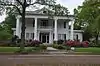 Provine House |
April 8, 1980 (#80002281) |
319 Grand Boulevard 33°31′39″N 90°11′13″W |
Greenwood | |
| 25 | Rebecca Site | January 11, 1991 (#90002105) |
Address Restricted |
Sidon | ||
| 26 | River Road and Western Downtown Residential Historic District | March 2, 1986 (#86000519) |
Roughly bounded by River Rd., Dewey and Gillespie, Washington and Johnson, and 1st Sts. 33°31′04″N 90°11′20″W |
Greenwood | ||
| 27 | Rosemary-Humphreys House | 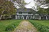 Rosemary-Humphreys House |
November 4, 1985 (#85003459) |
1440 Grand Boulevard 33°32′20″N 90°11′33″W |
Greenwood | |
| 28 | Southworth House | 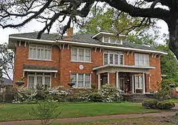 Southworth House |
November 4, 1985 (#85003460) |
1108 Mississippi Ave. 33°30′34″N 90°11′13″W |
Greenwood | |
| 29 | STAR OF THE WEST | STAR OF THE WEST |
May 21, 1975 (#75001050) |
West of Greenwood on the Tallahatchie River 33°31′54″N 90°13′59″W |
Greenwood | |
| 30 | Stratton Archeological Site | July 28, 1999 (#99000840) |
Address Restricted |
Sidon | ||
| 31 | Sweethome Mound | June 9, 1978 (#78001613) |
Address Restricted |
Wakeland | ||
| 32 | Wesley Memorial Methodist Episcopal | .jpg.webp) Wesley Memorial Methodist Episcopal |
November 4, 1985 (#85003461) |
800 Howard St. 33°30′49″N 90°10′52″W |
Greenwood | |
| 33 | Wesley Methodist Church Historic District | April 8, 1999 (#99000381) |
Roughly bounded by Cotton, Howard, Palace, Weeks Lane, and W. Johnson 33°30′41″N 90°10′54″W |
Greenwood | ||
| 34 | Whaley Archeological Site | March 15, 1976 (#76001101) |
Northwestern quarter of the northwestern quarter of Section 5, Township 20 North, Range 2 East[6]:57 33°36′20″N 90°07′04″W |
Whaley | ||
| 35 | W.M. Whittington House | July 19, 1984 (#84002255) |
401 E. Market St. 33°31′18″N 90°10′40″W |
Greenwood | ||
| 36 | Wildwood Plantation Commissary and Shop | September 18, 2013 (#13000734) |
Cty. Rd. 626 33°37′10″N 90°14′24″W |
Money | ||
| 37 | Williams Landing and Eastern Downtown Residential Historic District | March 2, 1986 (#86000520) |
Roughly bounded by Front, McLemore and Lamar, Market, and George Sts. 33°31′15″N 90°10′38″W |
Greenwood | ||
| 38 | Wright House | November 4, 1985 (#85003462) |
414 Fulton Ave. 33°31′02″N 90°10′59″W |
Greenwood |
See also
| Wikimedia Commons has media related to National Register of Historic Places in Leflore County, Mississippi. |
References
- The latitude and longitude information provided in this table was derived originally from the National Register Information System, which has been found to be fairly accurate for about 99% of listings. Some locations in this table may have been corrected to current GPS standards.
- "National Register of Historic Places: Weekly List Actions". National Park Service, United States Department of the Interior. Retrieved on January 29, 2021.
- Numbers represent an alphabetical ordering by significant words. Various colorings, defined here, differentiate National Historic Landmarks and historic districts from other NRHP buildings, structures, sites or objects.
- "National Register Information System". National Register of Historic Places. National Park Service. March 13, 2009.
- The eight-digit number below each date is the number assigned to each location in the National Register Information System database, which can be viewed by clicking the number.
- Phillips, Philip, et al. Archaeological Survey in the Lower Mississippi Alluvial Valley 1940-1947. Reprint ed. Tuscaloosa: U of Alabama P, 2003.
| Topics | |
|---|---|
| Lists by state |
|
| Lists by insular areas | |
| Lists by associated state | |
| Other areas | |
| Related | |
| |
Municipalities and communities of Leflore County, Mississippi, United States | ||
|---|---|---|
| Cities | Map of Mississippi highlighting Leflore County | |
| Towns | ||
| CDP | ||
| Unincorporated communities | ||
| Ghost town | ||
| Footnotes | ‡This populated place also has portions in an adjacent county or counties | |
| ||
This article is issued from Wikipedia. The text is licensed under Creative Commons - Attribution - Sharealike. Additional terms may apply for the media files.