National Register of Historic Places listings in Logan County, Illinois
This is a list of the National Register of Historic Places listings in Logan County, Illinois.
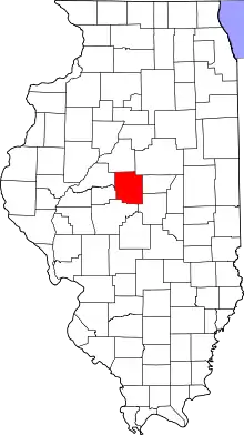
Location of Logan County in Illinois
This is intended to be a complete list of the properties and districts on the National Register of Historic Places in Logan County, Illinois, United States. Latitude and longitude coordinates are provided for many National Register properties and districts; these locations may be seen together in a map.[1]
There are 12 properties and districts listed on the National Register in the county.
- This National Park Service list is complete through NPS recent listings posted January 29, 2021.[2]
Current listings
| [3] | Name on the Register | Image | Date listed[4] | Location | City or town | Description |
|---|---|---|---|---|---|---|
| 1 | Allen Chapel African Methodist Episcopal Church |  Allen Chapel African Methodist Episcopal Church |
May 12, 2004 (#04000422) |
902 Broadway 40°08′41″N 89°21′33″W |
Lincoln | |
| 2 | Atlanta Public Library | 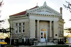 Atlanta Public Library |
December 11, 1979 (#79000852) |
Race and Arch Sts. 40°15′37″N 89°13′57″W |
Atlanta | |
| 3 | Robert Buckles Barn | 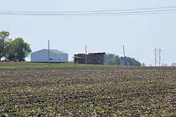 Robert Buckles Barn |
February 10, 1983 (#83000326) |
Southeast of Mount Pulaski 39°59′08″N 89°16′25″W |
Mount Pulaski | |
| 4 | Downey Building | 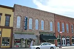 Downey Building |
February 25, 2004 (#04000069) |
110-112 SW. Arch St. 40°15′38″N 89°13′53″W |
Atlanta | |
| 5 | Stephan A. Foley House | 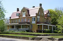 Stephan A. Foley House |
May 3, 1984 (#84001141) |
427 Tremont St. 40°09′08″N 89°21′54″W |
Lincoln | |
| 6 | J.H. Hawes Elevator | 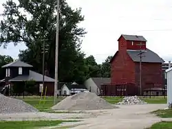 J.H. Hawes Elevator |
May 17, 1991 (#91000571) |
2nd St. 40°15′39″N 89°14′02″W |
Atlanta | |
| 7 | Hoblit House | 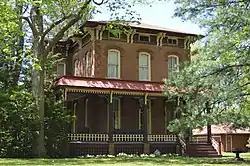 Hoblit House |
May 22, 2007 (#07000454) |
505 N. College Ave. 40°09′15″N 89°21′53″W |
Lincoln | |
| 8 | Lincoln Courthouse Square Historic District | 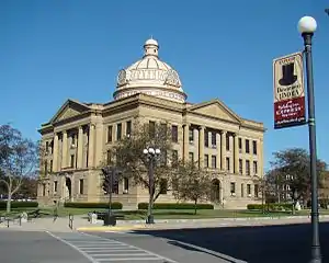 Lincoln Courthouse Square Historic District |
December 24, 1985 (#85003166) |
Roughly bounded by Sangamon, Pekin, Chicago, Delaware, Broadway, and Pulaski Sts. 40°08′46″N 89°21′45″W |
Lincoln | |
| 9 | Lincoln Public Library | 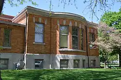 Lincoln Public Library |
September 12, 1980 (#80001384) |
725 Pekin St. 40°08′49″N 89°21′40″W |
Lincoln | |
| 10 | Theodore H. O. Mattfeldt House | 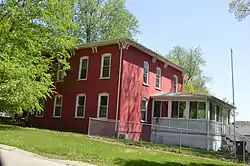 Theodore H. O. Mattfeldt House |
August 1, 1996 (#96000853) |
202 S. Marion St. 40°00′30″N 89°17′12″W |
Mount Pulaski | |
| 11 | Mount Pulaski Courthouse | 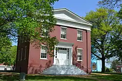 Mount Pulaski Courthouse |
August 3, 1978 (#78001164) |
Public Sq. 40°00′33″N 89°17′04″W |
Mount Pulaski | |
| 12 | University Hall | 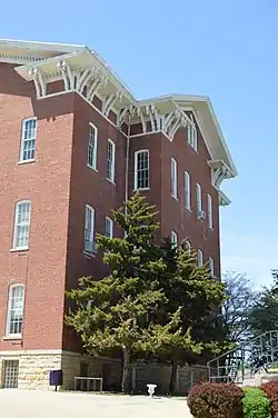 University Hall |
April 24, 1973 (#73000711) |
300 Keokuk St. 40°09′24″N 89°21′42″W |
Lincoln |
References
- The latitude and longitude information provided in this table was derived originally from the National Register Information System, which has been found to be fairly accurate for about 99% of listings. Some locations in this table may have been corrected to current GPS standards.
- "National Register of Historic Places: Weekly List Actions". National Park Service, United States Department of the Interior. Retrieved on January 29, 2021.
- Numbers represent an alphabetical ordering by significant words. Various colorings, defined here, differentiate National Historic Landmarks and historic districts from other NRHP buildings, structures, sites or objects.
- The eight-digit number below each date is the number assigned to each location in the National Register Information System database, which can be viewed by clicking the number.
See also
| Wikimedia Commons has media related to National Register of Historic Places in Logan County, Illinois. |
- List of National Historic Landmarks in Illinois
- National Register of Historic Places listings in Illinois
| Topics | |
|---|---|
| Lists by state |
|
| Lists by insular areas | |
| Lists by associated state | |
| Other areas | |
| Related | |
| |
This article is issued from Wikipedia. The text is licensed under Creative Commons - Attribution - Sharealike. Additional terms may apply for the media files.