National Register of Historic Places listings in Louisville's West End
This is a list of properties and historic districts on the National Register of Historic Places in the West End of Louisville, Kentucky. The table below includes 49 listings in the following neighborhoods:
Latitude and longitude coordinates of the sites listed on this page may be displayed in a map or exported in several formats by clicking on one of the links in the box below the map to the right.[1]
National Register sites elsewhere in Jefferson County are listed separately.
- This National Park Service list is complete through NPS recent listings posted February 5, 2021.[2]
Current listings
| [3] | Name on the Register | Image | Date listed[4] | Location | Neighborhood | Description |
|---|---|---|---|---|---|---|
| 1 | B.F. Avery and Sons Industrial District |  B.F. Avery and Sons Industrial District |
December 21, 1990 (#90001837) |
1721-1821 7th St. 38°13′16″N 85°46′23″W |
Algonquin | |
| 2 | Axton-Fisher Tobacco Company Warehouse | 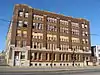 Axton-Fisher Tobacco Company Warehouse |
April 18, 2003 (#03000260) |
1405 W. Broadway 38°14′54″N 85°46′32″W |
Russell | |
| 3 | Wood F. Axton Hall, Simmons University | August 4, 2016 (#16000497) |
1811 Dumesnil St. 38°14′11″N 85°47′15″W |
Park Hill | ||
| 4 | Bernheim Distillery Bottling Plant |  Bernheim Distillery Bottling Plant |
September 8, 1983 (#83002634) |
822-828 S. 15th St. 38°14′43″N 85°46′40″W |
California | |
| 5 | Albert S. Brandeis Elementary School | Albert S. Brandeis Elementary School |
December 8, 1980 (#80001594) |
1001 S. 26th St. 38°14′35″N 85°47′43″W |
California | |
| 6 | Brass Finishing Building, Standard Sanitary Manufacturing Company | 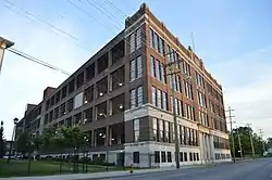 Brass Finishing Building, Standard Sanitary Manufacturing Company |
March 15, 2005 (#05000142) |
1547 S. 7th St. 38°13′30″N 85°46′12″W |
Algonquin | |
| 7 | Broadway Temple A.M.E. Zion Church | 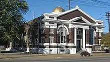 Broadway Temple A.M.E. Zion Church |
December 8, 1980 (#80001596) |
662 S. 13th St. 38°14′53″N 85°46′24″W |
Russell | |
| 8 | Chestnut Street Baptist Church |  Chestnut Street Baptist Church |
December 3, 1980 (#80001598) |
912 W. Chestnut St. 38°14′59″N 85°46′01″W |
Russell | |
| 9 | Christ the King School and Church | 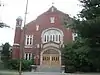 Christ the King School and Church |
September 8, 1983 (#83002647) |
718-724 S. 44th St. 38°14′57″N 85°49′32″W |
Shawnee | |
| 10 | Church of Our Merciful Saviour | 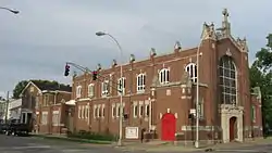 Church of Our Merciful Saviour |
September 8, 1983 (#83002648) |
473 S. 11th St. 38°15′09″N 85°46′08″W |
Russell | |
| 11 | Columbian School | 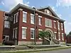 Columbian School |
September 8, 1983 (#83002650) |
1337 Dixie Hwy. 38°14′01″N 85°47′17″W |
Park Hill | Currently the Strothers Elementary Apartments |
| 12 | Anton Diebold House | 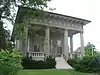 Anton Diebold House |
September 8, 1983 (#83002653) |
4303 W. Broadway 38°15′03″N 85°49′28″W |
Shawnee | |
| 13 | J.W. Diebold, Jr. House | 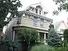 J.W. Diebold, Jr. House |
September 8, 1983 (#83002654) |
4119 W. Broadway 38°15′02″N 85°49′15″W |
Shawnee | |
| 14 | Basil Doerhoefer House | 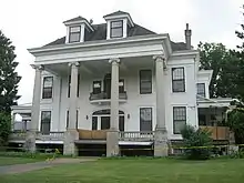 Basil Doerhoefer House |
September 8, 1983 (#83002657) |
4432 W. Broadway 38°15′00″N 85°49′36″W |
Shawnee | |
| 15 | Peter C. Doerhoefer House | 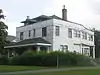 Peter C. Doerhoefer House |
September 8, 1983 (#83002658) |
4422 W. Broadway 38°15′00″N 85°49′33″W |
Shawnee | |
| 16 | Doerhoefer–Hampton House | 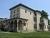 Doerhoefer–Hampton House |
July 16, 1979 (#79001002) |
2422 W. Chestnut St. 38°15′09″N 85°47′35″W |
Russell | |
| 17 | Dumesnil Street ME Church | 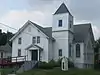 Dumesnil Street ME Church |
September 8, 1983 (#83002659) |
1707 Dumesnil St. 38°14′10″N 85°47′00″W |
Park Hill | |
| 18 | Fire Department Headquarters | 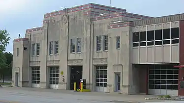 Fire Department Headquarters |
November 7, 1981 (#81000283) |
1135 W. Jefferson St. 38°15′20″N 85°46′12″W |
Russell | |
| 19 | Ford Motor Plant |  Ford Motor Plant |
January 27, 1983 (#83002666) |
1400 Southwestern Parkway 38°14′06″N 85°50′00″W |
West End Louisville | |
| 20 | Stephen Foster Elementary School |  Stephen Foster Elementary School |
April 4, 2006 (#06000337) |
4020 Garland Ave. 38°14′47″N 85°49′08″W |
Chickasaw | |
| 21 | Holy Cross Catholic Church, School and Rectory | 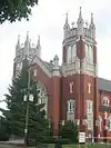 Holy Cross Catholic Church, School and Rectory |
September 8, 1983 (#83002684) |
3112 W. Broadway 38°14′58″N 85°48′18″W |
Russell | |
| 22 | Hook and Ladder Company No. 4 | 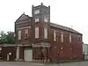 Hook and Ladder Company No. 4 |
November 7, 1980 (#80001603) |
2301 Jefferson St. 38°15′28″N 85°47′21″W |
Russell | |
| 23 | Hook and Ladder Company No. 5 | 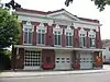 Hook and Ladder Company No. 5 |
November 7, 1980 (#80001604) |
1824 Garland Ave. 38°14′37″N 85°47′08″W |
California | |
| 24 | Jefferson Branch Louisville Free Public Library | 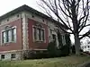 Jefferson Branch Louisville Free Public Library |
July 18, 1979 (#79001009) |
1718 W. Jefferson St. 38°15′22″N 85°46′46″W |
Russell | |
| 25 | Knights of Pythias Temple | 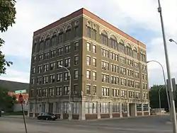 Knights of Pythias Temple |
November 29, 1978 (#78001358) |
928-932 W. Chestnut St. 38°14′59″N 85°46′04″W |
Russell | |
| 26 | Louisville and Nashville Railroad Office Building | 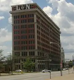 Louisville and Nashville Railroad Office Building |
September 8, 1983 (#83002696) |
908 W. Broadway 38°14′48″N 85°46′04″W |
California | |
| 27 | Louisville Free Public Library, Western Colored Branch | 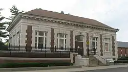 Louisville Free Public Library, Western Colored Branch |
December 6, 1975 (#75000771) |
604 S. 10th St. 38°14′59″N 85°46′05″W |
Russell | |
| 28 | Marlow Place Bungalows District | 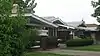 Marlow Place Bungalows District |
September 8, 1983 (#83002699) |
3139 to 3209 W. Broadway 38°15′00″N 85°48′20″W |
Russell | |
| 29 | J.B. McFerran School | 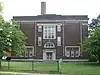 J.B. McFerran School |
September 8, 1983 (#83002703) |
1515 Cypress St. 38°13′47″N 85°47′54″W |
Algonquin | |
| 30 | Mengel Box Company | 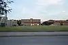 Mengel Box Company |
September 8, 1983 (#83002705) |
1247-1299 S. 12th St. 38°14′04″N 85°46′25″W |
Park Hill | |
| 31 | Parkland Evangelical Church |  Parkland Evangelical Church |
September 8, 1983 (#83002717) |
1102 S. 26th St. 38°14′26″N 85°47′47″W |
Parkland | |
| 32 | Parkland Historic District | 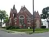 Parkland Historic District |
June 4, 1980 (#80001613) |
Roughly bounded by railroad tracks, Hale Ave., and S. 26th and S. 30th Sts. 38°14′12″N 85°48′00″W |
Parkland | |
| 33 | Parkland Junior High School | 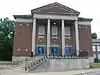 Parkland Junior High School |
September 8, 1983 (#83002718) |
2509 Wilson Ave. 38°14′06″N 85°47′44″W |
Parkland | |
| 34 | J.J. Reilly Manufacturing Building | June 13, 2019 (#100004097) |
1234 Rowan St. 38°15′35″N 85°46′15″W |
|||
| 34 | Russell Historic District | 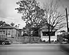 Russell Historic District |
May 7, 1980 (#80001617) |
Roughly bounded by S. 15th, S. 26th, Congress, and W. Broadway Sts.; also the junction of Muhammad Ali Boulevard and S. 17th St. 38°15′20″N 85°47′20″W |
Russell | Junction address represents a boundary increase of March 24, 2000 |
| 35 | St. Anthony's Roman Catholic Church, Rectory, Convent, and School |  St. Anthony's Roman Catholic Church, Rectory, Convent, and School |
March 1, 1982 (#82002720) |
2222-2233 W. Market St. 38°15′30″N 85°47′16″W |
Russell | |
| 36 | St. Columba Catholic Campus | 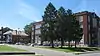 St. Columba Catholic Campus |
April 5, 2005 (#05000143) |
3514 W. Market 38°15′39″N 85°48′33″W |
Shawnee | |
| 37 | St. George's Roman Catholic Church | 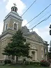 St. George's Roman Catholic Church |
October 29, 1982 (#82001563) |
1809 Standard Ave. 38°13′53″N 85°47′23″W |
Park Hill | |
| 38 | St. Peter's German Evangelical Church | 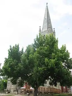 St. Peter's German Evangelical Church |
December 4, 1980 (#80001621) |
1231 W. Jefferson St. 38°15′20″N 85°46′16″W |
Russell | |
| 39 | Shawnee Elementary School | 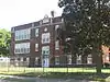 Shawnee Elementary School |
November 2, 1984 (#84000275) |
4151 Herman St. 38°15′43″N 85°49′08″W |
Shawnee | |
| 40 | Shawnee High School | 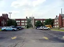 Shawnee High School |
November 2, 1984 (#84000277) |
4015 Herman St. 38°15′43″N 85°48′56″W |
Shawnee | |
| 41 | F.M. Tiller House | 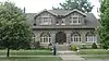 F.M. Tiller House |
September 8, 1983 (#83002741) |
4309 W. Broadway 38°15′03″N 85°49′30″W |
Shawnee | |
| 42 | Union Station | 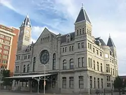 Union Station |
August 11, 1975 (#75000777) |
1000 W. Broadway 38°14′48″N 85°46′08″W |
California | |
| 43 | Universal Car Company | 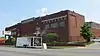 Universal Car Company |
May 2, 2001 (#01000454) |
2500 W. Broadway 38°14′57″N 85°47′38″W |
California | |
| 44 | Virginia Avenue Colored School | 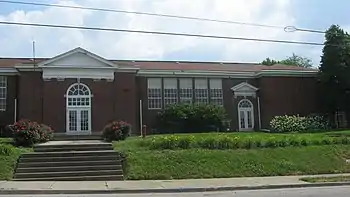 Virginia Avenue Colored School |
March 31, 2004 (#04000244) |
3628 Virginia Ave. 38°14′21″N 85°48′53″W |
Chickasaw | |
| 45 | Henry Vogt Machine Company Shop | 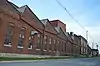 Henry Vogt Machine Company Shop |
February 11, 1982 (#82002727) |
1000 W. Ormsby Ave. 38°13′58″N 85°46′15″W |
Park Hill | |
| 46 | Warehouse A, Brown-Forman Corporation | 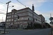 Warehouse A, Brown-Forman Corporation |
April 16, 1990 (#89001144) |
1809 Garland Ave. 38°14′40″N 85°47′04″W |
California | |
| 47 | Wedekind House and Servant's Quarters |  Wedekind House and Servant's Quarters |
September 8, 1983 (#83002747) |
2630 and 2532 W. Burnett St. 38°13′56″N 85°47′57″W |
Park Hill | |
| 48 | White Mills Distillery Company | 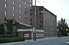 White Mills Distillery Company |
December 8, 1978 (#78001371) |
850 Dixie Hwy. 38°14′42″N 85°47′03″W |
California | |
| 49 | Whiteside Bakery | 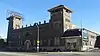 Whiteside Bakery |
April 24, 1979 (#79001014) |
1400 W. Broadway St. 38°14′52″N 85°46′32″W |
California |
See also
References
- The latitude and longitude information provided in this table was derived originally from the National Register Information System, which has been found to be fairly accurate for about 99% of listings. Some locations in this table may have been corrected to current GPS standards.
- "National Register of Historic Places: Weekly List Actions". National Park Service, United States Department of the Interior. Retrieved on February 5, 2021.
- Numbers represent an alphabetical ordering by significant words. Various colorings, defined here, differentiate National Historic Landmarks and historic districts from other NRHP buildings, structures, sites or objects.
- The eight-digit number below each date is the number assigned to each location in the National Register Information System database, which can be viewed by clicking the number.
| Topics | |
|---|---|
| Lists by state |
|
| Lists by insular areas | |
| Lists by associated state | |
| Other areas | |
| Related | |
| |
This article is issued from Wikipedia. The text is licensed under Creative Commons - Attribution - Sharealike. Additional terms may apply for the media files.