National Register of Historic Places listings in McHenry County, Illinois
This is a list of the National Register of Historic Places listings in McHenry County, Illinois.
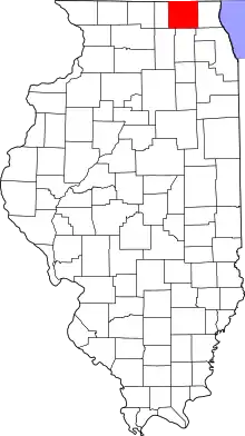
Location of McHenry County in Illinois
This is intended to be a complete list of the properties and districts on the National Register of Historic Places in McHenry County, Illinois, United States. Latitude and longitude coordinates are provided for many National Register properties and districts; these locations may be seen together in a map.[1]
There are 13 properties and districts listed on the National Register in the county.
- This National Park Service list is complete through NPS recent listings posted February 5, 2021.[2]
Current listings
| [3] | Name on the Register | Image | Date listed[4] | Location | City or town | Description |
|---|---|---|---|---|---|---|
| 1 | Count's House | 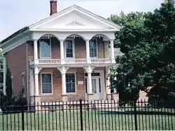 Count's House |
June 3, 1982 (#82002587) |
3803 Waukegan 42°20′36″N 88°16′17″W |
McHenry | |
| 2 | Lucein Boneparte Covell House |  Lucein Boneparte Covell House |
January 26, 1989 (#88003246) |
5805 Broadway 42°28′35″N 88°18′42″W |
Richmond | |
| 3 | Colby-Petersen Farm | 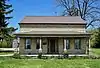 Colby-Petersen Farm |
March 13, 2020 (#100004853) |
4112 McCullom Lake Rd. 42°21′44″N 88°16′41″W |
McHenry | |
| 4 | Christian Geister House | 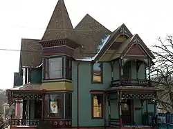 Christian Geister House |
September 25, 2007 (#07000453) |
302 S. Main St. 42°09′55″N 88°17′38″W |
Algonquin | |
| 5 | Charles H. Hibbard House |  Charles H. Hibbard House |
February 14, 1979 (#79003113) |
413 W. Grant Hwy. 42°14′54″N 88°36′45″W |
Marengo | |
| 6 | Memorial Hall | 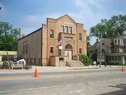 Memorial Hall |
August 19, 1993 (#93000839) |
10308 Main St. 42°28′32″N 88°18′21″W |
Richmond | |
| 7 | Old McHenry County Courthouse | 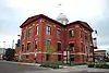 Old McHenry County Courthouse |
November 1, 1974 (#74002183) |
City Sq. 42°18′54″N 88°26′54″W |
Woodstock | |
| 8 | Col. Gustavus A. Palmer House | 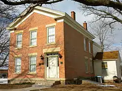 Col. Gustavus A. Palmer House |
May 24, 1985 (#85001127) |
5516 Terra Cotta Rd. 42°14′56″N 88°17′46″W |
Crystal Lake | |
| 9 | Orson Rogers House | 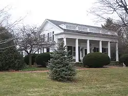 Orson Rogers House |
June 22, 1979 (#79003114) |
E of Marengo at 19621 E. Grant St. 42°14′11″N 88°34′51″W |
Marengo | |
| 10 | George Stickney House | 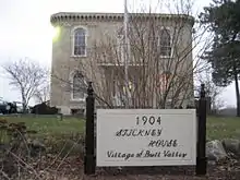 George Stickney House |
May 14, 1979 (#79003115) |
NE of Woodstock at 1904 Cherry Valley Rd. 42°18′03″N 88°21′09″W |
Bull Valley | |
| 11 | Terwilliger House | 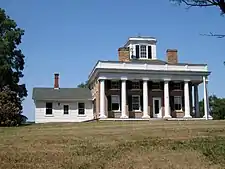 Terwilliger House |
May 14, 1979 (#79003116) |
E of Woodstock at Mason Hill and Cherry Valley Rds. 42°18′22″N 88°21′12″W |
Bull Valley | |
| 12 | Woodstock Opera House | 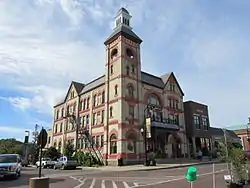 Woodstock Opera House |
July 17, 1974 (#74002184) |
119 Van Buren St. 42°18′52″N 88°26′52″W |
Woodstock | |
| 13 | Woodstock Square Historic District | 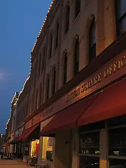 Woodstock Square Historic District |
November 12, 1982 (#82000399) |
Roughly bounded by Calhoun, Throop, Cass, Main, C and NW RR Tracks, and Jefferson Sts. 42°18′55″N 88°26′52″W |
Woodstock |
See also
| Wikimedia Commons has media related to National Register of Historic Places in McHenry County, Illinois. |
References
- The latitude and longitude information provided in this table was derived originally from the National Register Information System, which has been found to be fairly accurate for about 99% of listings. Some locations in this table may have been corrected to current GPS standards.
- "National Register of Historic Places: Weekly List Actions". National Park Service, United States Department of the Interior. Retrieved on February 5, 2021.
- Numbers represent an alphabetical ordering by significant words. Various colorings, defined here, differentiate National Historic Landmarks and historic districts from other NRHP buildings, structures, sites or objects.
- The eight-digit number below each date is the number assigned to each location in the National Register Information System database, which can be viewed by clicking the number.
| Topics | |
|---|---|
| Lists by state |
|
| Lists by insular areas | |
| Lists by associated state | |
| Other areas | |
| Related | |
| |
This article is issued from Wikipedia. The text is licensed under Creative Commons - Attribution - Sharealike. Additional terms may apply for the media files.