National Register of Historic Places listings in Montgomery County, Illinois
This is a list of the National Register of Historic Places listings in Montgomery County, Illinois.
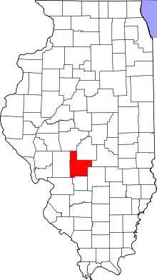
Location of Montgomery County in Illinois
This is intended to be a complete list of the properties and districts on the National Register of Historic Places in Montgomery County, Illinois, United States. Latitude and longitude coordinates are provided for many National Register properties and districts; these locations may be seen together in a map.[1]
There are 13 properties and districts listed on the National Register in the county.
- This National Park Service list is complete through NPS recent listings posted January 29, 2021.[2]
Current listings
| [3] | Name on the Register[4] | Image | Date listed[5] | Location | City or town | Description |
|---|---|---|---|---|---|---|
| 1 | Ariston Cafe | 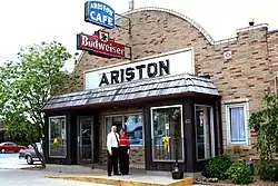 Ariston Cafe |
May 5, 2006 (#06000380) |
413 Old U.S. Route 66 39°10′38″N 89°40′05″W |
Litchfield | |
| 2 | Belvidere Café, Motel, and Gas Station | 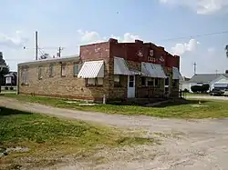 Belvidere Café, Motel, and Gas Station |
February 21, 2007 (#07000060) |
817 Old U.S. Route 66 39°10′16″N 89°40′03″W |
Litchfield | |
| 3 | George Blackman House | 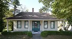 George Blackman House |
November 6, 1986 (#86003180) |
904 S. Main St. 39°09′11″N 89°29′37″W |
Hillsboro | |
| 4 | Brown Shoe Company Factory | 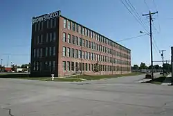 Brown Shoe Company Factory |
November 15, 2006 (#06001019) |
212 S. State St. 39°10′26″N 89°39′16″W |
Litchfield | |
| 5 | Freeman-Brewer-Sawyer House | 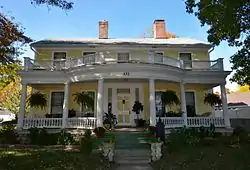 Freeman-Brewer-Sawyer House |
November 5, 1992 (#92001536) |
532 S. Main St. 39°09′22″N 89°29′38″W |
Hillsboro | |
| 6 | Samuel Moody Grubbs House | 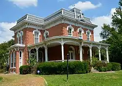 Samuel Moody Grubbs House |
February 21, 1990 (#90000156) |
805 E. Union 39°10′42″N 89°38′47″W |
Litchfield | |
| 7 | Hayward-Hill House | 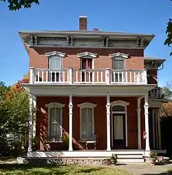 Hayward-Hill House |
May 8, 1980 (#80001399) |
540 S. Main St. 39°09′23″N 89°29′00″W |
Hillsboro | |
| 8 | Litchfield Elks Lodge No. 654 | 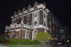 Litchfield Elks Lodge No. 654 |
March 3, 1995 (#95000195) |
424 N. Monroe St. 39°10′41″N 89°39′14″W |
Litchfield | |
| 9 | Litchfield Public Library | 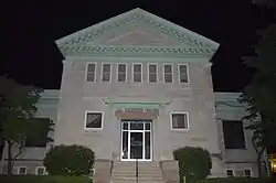 Litchfield Public Library |
February 12, 1999 (#99000165) |
400 N. State St. 39°10′40″N 89°39′17″W |
Litchfield | |
| 10 | Manske-Niemann Farm | 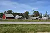 Manske-Niemann Farm |
February 27, 2003 (#03000065) |
13 Franks Ln. 39°08′18″N 89°41′03″W |
Litchfield | |
| 11 | Montgomery County Courthouse |  Montgomery County Courthouse |
October 28, 1994 (#94001266) |
Courthouse Sq. 39°09′40″N 89°29′36″W |
Hillsboro | |
| 12 | Route 66, Litchfield to Mount Olive |  Route 66, Litchfield to Mount Olive |
November 29, 2001 (#01001312) |
U.S. Route 66, north of Illinois Route 16 in Litchfield to Mount Olive 39°07′48″N 89°41′34″W |
Litchfield | |
| 13 | Lewis H. Thomas House | December 7, 1983 (#83003586) |
N. Virden Rd. 39°30′31″N 89°38′37″W |
Virden |
See also
| Wikimedia Commons has media related to National Register of Historic Places in Montgomery County, Illinois. |
References
- The latitude and longitude information provided in this table was derived originally from the National Register Information System, which has been found to be fairly accurate for about 99% of listings. Some locations in this table may have been corrected to current GPS standards.
- "National Register of Historic Places: Weekly List Actions". National Park Service, United States Department of the Interior. Retrieved on January 29, 2021.
- Numbers represent an alphabetical ordering by significant words. Various colorings, defined here, differentiate National Historic Landmarks and historic districts from other NRHP buildings, structures, sites or objects.
- "National Register Information System". National Register of Historic Places. National Park Service. March 13, 2009.
- The eight-digit number below each date is the number assigned to each location in the National Register Information System database, which can be viewed by clicking the number.
| Topics | |
|---|---|
| Lists by state |
|
| Lists by insular areas | |
| Lists by associated state | |
| Other areas | |
| Related | |
| |
Municipalities and communities of Montgomery County, Illinois, United States | ||
|---|---|---|
| Cities | Map of Illinois highlighting Montgomery County | |
| Villages | ||
| Townships | ||
| Unincorporated communities | ||
| Footnotes | ‡This populated place also has portions in an adjacent county or counties | |
| ||
This article is issued from Wikipedia. The text is licensed under Creative Commons - Attribution - Sharealike. Additional terms may apply for the media files.