National Register of Historic Places listings in Ouachita Parish, Louisiana
This is a list of the National Register of Historic Places listings in Ouachita Parish, Louisiana.
Location of Ouachita Parish in Louisiana
This is intended to be a complete list of the properties and districts on the National Register of Historic Places in Ouachita Parish, Louisiana, United States. The locations of National Register properties and districts for which the latitude and longitude coordinates are included below, may be seen in a map.[1]
There are 32 properties and districts listed on the National Register in the parish. One property was once listed, but has since been removed.
- This National Park Service list is complete through NPS recent listings posted January 29, 2021.[2]
Current listings
| [3] | Name on the Register[4] | Image | Date listed[5] | Location | City or town | Description |
|---|---|---|---|---|---|---|
| 1 | Allen-Barringer House | May 3, 1982 (#82002790) |
Southwest of West Monroe off Elkins Rd. 32°25′33″N 92°11′39″W |
West Monroe | ||
| 2 | J.S. Block Building | September 30, 1980 (#80001747) |
101 N. Grand St. 32°29′59″N 92°07′01″W |
Monroe | ||
| 3 | Bosco Plantation House |  Bosco Plantation House |
November 18, 2009 (#09000931) |
279 Pipes Ln. 32°17′03″N 92°05′46″W |
Monroe | |
| 4 | Boscobel Cottage |  Boscobel Cottage |
May 7, 1979 (#79001078) |
Cordell Lane 32°17′23″N 92°05′33″W |
Bosco | |
| 5 | Bright-Lamkin-Easterling House |  Bright-Lamkin-Easterling House |
May 15, 1986 (#86001063) |
918 Jackson St. 32°29′42″N 92°06′44″W |
Monroe | |
| 6 | Bynum House |  Bynum House |
January 25, 1997 (#96001611) |
604 Grammont St. 32°30′08″N 92°06′42″W |
Monroe | |
| 7 | G.B. Cooley House |  G.B. Cooley House |
May 15, 1986 (#86001060) |
1011 S. Grand St. 32°29′33″N 92°06′50″W |
Monroe | |
| 8 | Downtown Monroe Historic District | 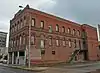 Downtown Monroe Historic District |
September 4, 1986 (#86002202) |
Roughly bounded by Desiard, Jackson, Telemaque, and S. Grand Sts.; also roughly bounded by Ouachita R., Harrison, N. & S. 6th, Washington & Breard Sts. 32°30′01″N 92°06′57″W |
Monroe | Second set of address represents a boundary increase approved January 31, 2017. |
| 9 | Roland M. Filhiol House | July 7, 1995 (#95000813) |
111 Stone Ave. 32°29′46″N 92°06′46″W |
Monroe | ||
| 10 | First United Methodist Church | 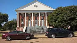 First United Methodist Church |
June 12, 2001 (#01000491) |
101 N. 2nd St. 32°29′58″N 92°07′28″W |
West Monroe | |
| 11 | Isaiah Garrett Law Office | July 12, 1976 (#76000972) |
520 S. Grand St. 32°29′49″N 92°06′57″W |
Monroe | ||
| 12 | Grayson House |  Grayson House |
November 17, 1999 (#99001303) |
2300 DeSiard St. 32°30′50″N 92°05′50″W |
Monroe | |
| 13 | Gov. Luther Hall House | 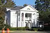 Gov. Luther Hall House |
May 7, 1979 (#79001079) |
1515 Jackson St. 32°29′N 92°07′W |
Monroe | |
| 14 | Harvey House | January 25, 1997 (#96001610) |
608 Grammont St. 32°30′09″N 92°06′42″W |
Monroe | ||
| 15 | Key-Mize House | 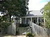 Key-Mize House |
November 10, 2001 (#01001212) |
118 Copley St. 32°31′08″N 92°08′09″W |
West Monroe | |
| 16 | Logtown Plantation |  Logtown Plantation |
October 16, 1980 (#80001748) |
South of Monroe 32°20′07″N 92°05′24″W |
Monroe | |
| 17 | Lower Pargoud | October 4, 1984 (#84000015) |
2111 S. Grand St. 32°28′54″N 92°06′43″W |
Monroe | ||
| 18 | Masur House | 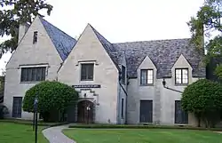 Masur House |
July 22, 1982 (#82002789) |
901 N. 3rd St. 32°30′34″N 92°07′21″W |
Monroe | |
| 19 | McClendon House | April 18, 1996 (#96000432) |
309 McClendon 32°29′53″N 92°07′27″W |
West Monroe | ||
| 20 | Miller-Roy Building | 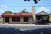 Miller-Roy Building |
March 7, 2011 (#11000075) |
1001 Desiard St. 32°30′25″N 92°06′34″W |
Monroe | |
| 21 | Milner Motors | July 25, 2001 (#01000764) |
212 Walnut St. 32°30′11″N 92°07′08″W |
Monroe | ||
| 22 | Monroe Residential Historic District | October 3, 1996 (#96001062) |
Roughly bounded by McKinley St., 7th St., Hudson Lne., and Riverside Dr. 32°31′05″N 92°07′33″W |
Monroe | ||
| 23 | Mulberry Grove | 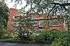 Mulberry Grove |
July 7, 1978 (#78001434) |
1133 S. Grand St. 32°29′29″N 92°06′46″W |
Monroe | |
| 24 | Neville High School | May 9, 1985 (#85000973) |
600 Forsythe Ave. 32°31′19″N 92°07′33″W |
Monroe | ||
| 25 | Ouachita Coca-Cola Bottling Company, Inc.-Ouachita Candy Company, Inc. | May 9, 2013 (#13000275) |
215 Walnut St. 32°30′11″N 92°07′10″W |
Monroe | ||
| 26 | Ouachita Parish High School | April 9, 1981 (#81000297) |
500 S. Grand St. 32°29′17″N 92°06′56″W |
Monroe | ||
| 27 | Rawls Cabin | August 9, 1991 (#91001047) |
223 Charlie Rawls Rd. 32°20′52″N 92°10′10″W |
West Monroe | ||
| 28 | Robinson Business College | April 18, 1997 (#97000354) |
604 Jack McEnery Ave. 32°28′19″N 92°06′32″W |
Monroe | ||
| 29 | Slagle House |  Slagle House |
January 24, 1995 (#94001590) |
1400 S. Grand 32°29′24″N 92°06′47″W |
Monroe | |
| 30 | West Monroe Historic District | May 20, 2019 (#100003414) |
Parts of Commerce, Cotton, Cypress, Natchitoches, Pine, N. Riverfront, Trenton & Wood Sts. 32°30′04″N 92°07′29″W |
West Monroe | ||
| 31 | Whitehall Plantation House |  Whitehall Plantation House |
September 8, 1987 (#87001475) |
Buckhorn Bend Rd. 32°25′50″N 92°06′50″W |
Monroe | |
| 32 | Wossman House | August 5, 1999 (#99000930) |
1205 St. John Dr. 32°29′27″N 92°06′41″W |
Monroe |
Former listing
| [3] | Name on the Register | Image | Date listed | Date removed | Location | City or town | Summary |
|---|---|---|---|---|---|---|---|
| 1 | St. James United Methodist Church | October 29, 1992 (#92001519) | March 31, 2015 | 916 Adams St. 32°30′35″N 92°06′19″W |
Monroe |
See also
| Wikimedia Commons has media related to National Register of Historic Places in Ouachita Parish, Louisiana. |
References
- The latitude and longitude information provided in this table was derived originally from the National Register Information System, which has been found to be fairly accurate for about 99% of listings. Some locations in this table may have been corrected to current GPS standards.
- "National Register of Historic Places: Weekly List Actions". National Park Service, United States Department of the Interior. Retrieved on January 29, 2021.
- Numbers represent an alphabetical ordering by significant words. Various colorings, defined here, differentiate National Historic Landmarks and historic districts from other NRHP buildings, structures, sites or objects.
- "National Register Information System". National Register of Historic Places. National Park Service. March 13, 2009.
- The eight-digit number below each date is the number assigned to each location in the National Register Information System database, which can be viewed by clicking the number.
| Topics | |
|---|---|
| Lists by state |
|
| Lists by insular areas | |
| Lists by associated state | |
| Other areas | |
| Related | |
| |
Municipalities and communities of Ouachita Parish, Louisiana, United States | ||
|---|---|---|
| Cities | | |
| Towns | ||
| CDPs | ||
| Other unincorporated communities | ||
| ||
This article is issued from Wikipedia. The text is licensed under Creative Commons - Attribution - Sharealike. Additional terms may apply for the media files.