National Register of Historic Places listings in Plaquemines Parish, Louisiana
This is a list of the National Register of Historic Places listings in Plaquemines Parish, Louisiana.

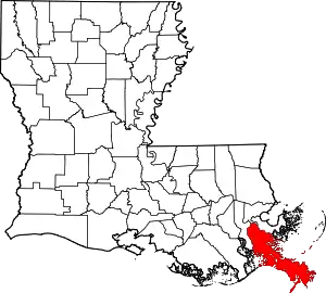
Location of Plaquemines Parish in Louisiana
This is intended to be a complete list of the properties on the National Register of Historic Places in Plaquemines Parish, Louisiana, United States. The locations of National Register properties for which the latitude and longitude coordinates are included below, may be seen in a map.[1]
There are 16 properties listed on the National Register in the parish.
- This National Park Service list is complete through NPS recent listings posted February 5, 2021.[2]
Current listings
| [3] | Name on the Register | Image | Date listed[4] | Location | City or town | Description |
|---|---|---|---|---|---|---|
| 1 | Fort De La Boulaye Site | October 15, 1966 (#66000378) |
Eastern bank of the Mississippi River, along Louisiana Highway 39[5] 29°38′57″N 89°56′40″W |
Phoenix | Fort De La Boulaye was a fort built in 1699–1700, when France took control of the mouth of the Mississippi River. Located less than one mile northeast of highway 39 on the Joe Gravolet canal. Historic marker recently returned on site reads: "FORT de la BOULAYE First white settlement in present day Louisiana, erected on this spot (then the bank of the Mississippi), prevented Britain's seizure of the Mississippi Valley." | |
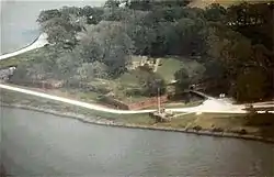
| 2 | Fort Jackson |  Fort Jackson |
October 15, 1966 (#66000379) |
2.5 miles southeast of Triumph on Louisiana Highway 23 on the western bank of the Mississippi River 29°21′22″N 89°27′18″W |
Triumph | Fort Jackson was constructed between 1822 and 1832. In April 1862, it was the site of the Battle of Forts Jackson and St. Philip, the decisive battle for control of New Orleans during the American Civil War. A state-operated park, the fort was flooded in 2005 for several weeks following Hurricanes Katrina and Rita. |
| 3 | Fort St. Philip |  Fort St. Philip |
October 15, 1966 (#66000380) |
2.5 miles southeast of Triumph on Louisiana Highway 23 on the eastern bank of the Mississippi River 29°21′45″N 89°27′58″W |
Triumph | Originally established in the 18th-century colonial period, Fort St. Philip's two important engagements were ten-day naval sieges during the War of 1812 and the American Civil War, the former an 1815 American victory against the British Royal Navy and the latter an 1862 Union Navy victory over Confederate forces guarding New Orleans. The site is privately owned and has deteriorated greatly because of river flooding, erosion, and tropical storms. |
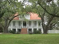
| 4 | Harlem Plantation House |  Harlem Plantation House |
October 26, 1982 (#82000451) |
West of Pointe à la Hache on Louisiana Highway 39 29°37′28″N 89°54′10″W |
Pointe à la Hache | |
| 5 | George Lincoln House | May 31, 2016 (#16000301) |
30763 Parish Hwy. 11 29°44′44″N 90°01′08″W |
Nairn | ||
| 6 | Mary Plantation House |  Mary Plantation House |
July 13, 1983 (#83000533) |
Louisiana Highway 39 29°48′15″N 89°59′59″W |
Braithwaite | Plantation house dating to Spanish Colonial era |
| 7 | Promised Land |  Promised Land |
September 11, 1997 (#97001128) |
5907 Louisiana Highway 39 29°47′43″N 90°00′15″W |
Braithwaite | Mansion of Plaquemines Parish boss Leander Perez |
| 8 | S.S. Gulfoil (shipwreck and remains) | June 13, 2018 (#100002556) |
Address Restricted |
Pilottown | ||
| 9 | S.S. Gulfpenn (shipwreck and remains) | June 13, 2018 (#100002557) |
Address Restricted |
Pilottown | ||
| 10 | S.S. Robert E. Lee and U-166 (shipwrecks and remains) |  S.S. Robert E. Lee and U-166 (shipwrecks and remains) |
December 7, 2018 (#100002558) |
Address Restricted |
Pilottown | German submarine U-166 (1941) |
| 11 | S.S. Virginia (shipwreck and remains) | June 13, 2018 (#100002559) |
Address Restricted |
Pilottown | ||
| 12 | S.S. Alcoa Puritan (shipwreck and remains) | June 13, 2018 (#100002560) |
Address Restricted |
Pilottown | ||
| 13 | Steam Yacht Anona (Shipwreck) | October 15, 2018 (#100003067) |
Address Restricted |
Pilottown | ||
| 14 | St. Patrick's Catholic Church | December 17, 1999 (#99001571) |
21997 Louisiana Highway 23 29°27′09″N 89°37′34″W |
West Pointe à la Hache | Wood frame church built in 1918 to replace former church destroyed in 1915 hurricane. Later moved. | |
| 15 | St. Thomas the Apostle Catholic Church and Cemetery | .jpg.webp) St. Thomas the Apostle Catholic Church and Cemetery |
June 22, 2018 (#100002585) |
17605 Louisiana Highway 15 29°35′07″N 89°48′24″W |
Pointe à la Hache | |
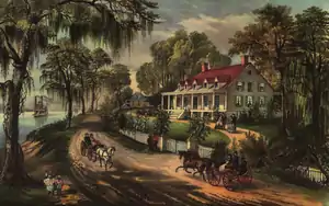
| 16 | Woodland Plantation |  Woodland Plantation |
June 18, 1998 (#98000702) |
21997 Louisiana Highway 23 29°35′08″N 89°49′34″W |
West Pointe à la Hache |
See also
| Wikimedia Commons has media related to National Register of Historic Places in Plaquemines Parish, Louisiana. |
References
- The latitude and longitude information provided in this table was derived originally from the National Register Information System, which has been found to be fairly accurate for about 99% of listings. Some locations in this table may have been corrected to current GPS standards.
- "National Register of Historic Places: Weekly List Actions". National Park Service, United States Department of the Interior. Retrieved on February 5, 2021.
- Numbers represent an alphabetical ordering by significant words. Various colorings, defined here, differentiate National Historic Landmarks and historic districts from other NRHP buildings, structures, sites or objects.
- The eight-digit number below each date is the number assigned to each location in the National Register Information System database, which can be viewed by clicking the number.
- Location derived from its GNIS feature record; the NRIS lists the site as "Address Restricted"
This article is issued from Wikipedia. The text is licensed under Creative Commons - Attribution - Sharealike. Additional terms may apply for the media files.