National Register of Historic Places listings in Pointe Coupee Parish, Louisiana
This is a list of the National Register of Historic Places listings in Pointe Coupee Parish, Louisiana.
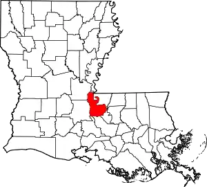
Location of Pointe Coupee Parish in Louisiana
This is intended to be a complete list of the properties on the National Register of Historic Places in Pointe Coupee Parish, Louisiana, United States. The locations of National Register properties for which the latitude and longitude coordinates are included below, may be seen in a map.[1]
There are 32 properties listed on the National Register in the parish, including 1 National Historic Landmark.
- This National Park Service list is complete through NPS recent listings posted January 29, 2021.[2]
Current listings
| [3] | Name on the Register[4] | Image | Date listed[5] | Location | City or town | Description |
|---|---|---|---|---|---|---|
| 1 | Austerlitz | 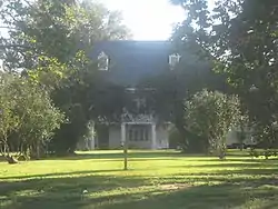 Austerlitz |
April 22, 1991 (#91000416) |
Louisiana Highway 1 southeast of its junction with Louisiana Highway 78 30°37′15″N 91°28′40″W |
Oscar | |
| 2 | Jean Baptiste Bergeron House |  Jean Baptiste Bergeron House |
May 13, 1994 (#94000407) |
13769 Chenal Rd. 30°36′40″N 91°22′51″W |
Jarreau | |
| 3 | Valmont Bergeron House |  Valmont Bergeron House |
May 14, 1992 (#92000512) |
Louisiana Highway 414 30°36′43″N 91°22′49″W |
Jarreau | |
| 4 | Bonnie Glen |  Bonnie Glen |
January 11, 1980 (#80001749) |
Southwest of New Roads on Louisiana Highway 1 30°39′16″N 91°29′12″W |
New Roads | |
| 5 | Cherie Quarters Cabins |  Cherie Quarters Cabins |
April 26, 1995 (#95000470) |
Major Ln., approximately ½ mile from its junction with Louisiana Highway 1 30°36′03″N 91°26′10″W |
Oscar | |
| 6 | Jacques Dupre House |  Jacques Dupre House |
December 5, 2003 (#03001232) |
13987 Chenal Rd. 30°36′49″N 91°22′48″W |
Jarreau | |
| 7 | El Dorado Plantation House | 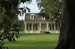 El Dorado Plantation House |
March 24, 1982 (#82002791) |
Bayou Maringouin, Louisiana Highway 77 30°31′20″N 91°32′45″W |
Livonia | |
| 8 | First National Bank |  First National Bank |
June 20, 2002 (#02000653) |
102 E. Main St. 30°41′33″N 91°26′03″W |
New Roads | |
| 9 | Glynnwood | 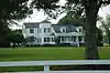 Glynnwood |
November 2, 1982 (#82000452) |
Louisiana Highway 416 30°37′27″N 91°21′24″W |
Glynn | |
| 10 | Labatut | 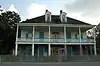 Labatut |
August 15, 1991 (#91001056) |
Junction of Louisiana Highways 10 and Louisiana Highway 420 30°43′45″N 91°29′00″W |
New Roads | |
| 11 | Lakeside | March 29, 1984 (#84001346) |
Louisiana Highway 419 30°50′15″N 91°38′40″W |
Batchelor | ||
| 12 | LeBeau House and Kitchen | May 9, 1985 (#85000974) |
Louisiana Highway 414 30°37′10″N 91°22′35″W |
Jarreau | ||
| 13 | LeJeune House | 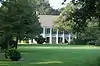 LeJeune House |
November 28, 1978 (#78001435) |
507 E. Main St. 30°41′40″N 91°25′47″W |
New Roads | |
| 14 | Albin Major House | 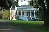 Albin Major House |
April 22, 1991 (#91000415) |
1304 False River Rd. (Louisiana Highway 1) 30°41′22″N 91°26′50″W |
New Roads | |
| 15 | Mix Store and Post Office | 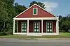 Mix Store and Post Office |
June 19, 2018 (#100002587) |
9253 False River Rd. 30°39′30″N 91°29′04″W |
New Roads | |
| 16 | North Bend | 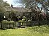 North Bend |
October 8, 1992 (#92001336) |
Louisiana Highway 1 west of its junction with Louisiana Highway 416, east of Oscar 30°36′41″N 91°26′52″W |
Oscar | |
| 17 | Old Hickory | 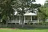 Old Hickory |
June 15, 1979 (#79001081) |
Southeast of LaCour 30°49′27″N 91°36′11″W |
LaCour | |
| 18 | Parlange Plantation House | .jpg.webp) Parlange Plantation House |
April 15, 1970 (#70000258) |
Junction of Louisiana Highways 1 and 78 30°37′49″N 91°29′14″W |
Mix | Large two-story French Colonial home built circa 1750 by Vincent de Ternant. Used as military headquarters by both C.S.A. and Union generals during the Civil War. Open by appointment. |
| 19 | Pleasant View Plantation House | April 5, 1984 (#84001347) |
Louisiana Highway 1 30°36′51″N 91°27′28″W |
Oscar | ||
| 20 | Pointe Coupee Parish Courthouse | 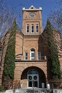 Pointe Coupee Parish Courthouse |
October 7, 1981 (#81000710) |
Main St. 30°41′38″N 91°25′57″W |
New Roads | |
| 21 | Pointe Coupee Parish Museum | 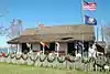 Pointe Coupee Parish Museum |
September 30, 1980 (#80001750) |
6 miles southwest of New Roads on Louisiana Highway 1 30°37′59″N 91°29′13″W |
New Roads | |
| 22 | Poydras High School | 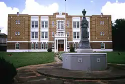 Poydras High School |
March 7, 1996 (#96000229) |
500 W. Main St. 30°41′34″N 91°26′16″W |
New Roads | |
| 23 | Fannie Riche House | .jpg.webp) Fannie Riche House |
April 22, 1991 (#91000413) |
Louisiana Highway 420 near its junction with Louisiana Highway 10 30°43′46″N 91°28′19″W |
New Roads | |
| 24 | Riverlake | 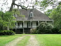 Riverlake |
April 13, 1983 (#83000534) |
Louisiana Highway 1 30°36′28″N 91°26′07″W |
Oscar | |
| 25 | St. Francis Chapel | 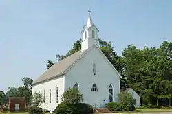 St. Francis Chapel |
May 25, 1979 (#79001082) |
Northwest of New Roads on Louisiana Highway 10 30°43′45″N 91°29′12″W |
New Roads | |
| 26 | St. Stephen's Episcopal Church | .jpg.webp) St. Stephen's Episcopal Church |
April 24, 1974 (#74000939) |
North of Innis off Louisiana Highway 418 30°53′52″N 91°40′09″W |
Innis | |
| 27 | Saizon House | 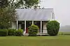 Saizon House |
April 22, 1991 (#91000417) |
Louisiana Highway 414 east of its junction with Louisiana Highway 413 30°36′32″N 91°23′03″W |
Jarreau | |
| 28 | Samson House | 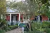 Samson House |
December 19, 1997 (#97001515) |
405 Richey St. 30°41′45″N 91°26′08″W |
New Roads | |
| 29 | Satterfield Motor Company Building | 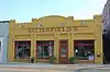 Satterfield Motor Company Building |
July 7, 1994 (#94000700) |
108 E. Main St. 30°41′34″N 91°26′01″W |
New Roads | |
| 30 | Valverda Plantation House | 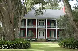 Valverda Plantation House |
April 1, 2002 (#02000297) |
2217 Louisiana Highway 977 30°32′19″N 91°32′43″W |
Maringouin | |
| 31 | White Hall Plantation House | 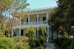 White Hall Plantation House |
May 26, 1977 (#77000677) |
East of Simmesport on Louisiana Highway 418 30°58′59″N 91°46′42″W |
Simmesport | Late 1840s Italianate and Greek Revival mansion attributed to architect Henry Howard. Used as a headquarters by Union General Nathaniel Banks in 1863. Restored and opened to the public in 2013. |
| 32 | Wickliffe | 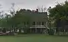 Wickliffe |
April 22, 1991 (#91000414) |
Louisiana Highway 415 east of Patin Duke Slough 30°40′59″N 91°22′58″W |
New Roads |
Former listings
| [3] | Name on the Register | Image | Date listed | Date removed | Location | City or town | Summary |
|---|---|---|---|---|---|---|---|
| 1 | Ovide LaCour Store | July 27, 1979 (#79001080) |
Louisiana Highway 419 30°49′40″N 91°36′38″W |
LaCour |
See also
| Wikimedia Commons has media related to National Register of Historic Places in Pointe Coupee Parish, Louisiana. |
References
- The latitude and longitude information provided in this table was derived originally from the National Register Information System, which has been found to be fairly accurate for about 99% of listings. Some locations in this table may have been corrected to current GPS standards.
- "National Register of Historic Places: Weekly List Actions". National Park Service, United States Department of the Interior. Retrieved on January 29, 2021.
- Numbers represent an alphabetical ordering by significant words. Various colorings, defined here, differentiate National Historic Landmarks and historic districts from other NRHP buildings, structures, sites or objects.
- "National Register Information System". National Register of Historic Places. National Park Service. March 13, 2009.
- The eight-digit number below each date is the number assigned to each location in the National Register Information System database, which can be viewed by clicking the number.
| Topics | |
|---|---|
| Lists by state |
|
| Lists by insular areas | |
| Lists by associated state | |
| Other areas | |
| Related | |
| |
Municipalities and communities of Pointe Coupee Parish, Louisiana, United States | ||
|---|---|---|
| City | | |
| Towns | ||
| Village | ||
| CDP | ||
| Other unincorporated communities | ||
| Ghost towns | ||
| ||
This article is issued from Wikipedia. The text is licensed under Creative Commons - Attribution - Sharealike. Additional terms may apply for the media files.