National Register of Historic Places listings in Rosebud County, Montana
This is a list of the National Register of Historic Places listings in Rosebud County, Montana. It is intended to be a complete list of the properties and districts on the National Register of Historic Places in Rosebud County, Montana, United States. The locations of National Register properties and districts for which the latitude and longitude coordinates are included below, may be seen in a map.[1]
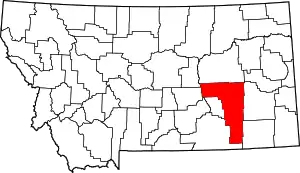
Location of Rosebud County in Montana
There are 21 properties and districts listed on the National Register in the county, including 1 National Historic Landmark.
- This National Park Service list is complete through NPS recent listings posted January 29, 2021.[2]
Listings county-wide
| [3] | Name on the Register | Image | Date listed[4] | Location | City or town | Description |
|---|---|---|---|---|---|---|
| 1 | Herman and Hannah Anderson House | February 12, 1990 (#90000084) |
209 S. 7th Ave. 46°15′43″N 106°40′48″W |
Forsyth | ||
| 2 | Blue Front Rooming House | February 12, 1990 (#90000085) |
1187 Main St. 46°16′02″N 106°40′32″W |
Forsyth | ||
| 3 | Bones Brothers Ranch | March 19, 2004 (#04000220) |
Along Hanging Woman Creek, 3 miles southeast of Birney and west of Custer National Forest 45°17′16″N 106°29′16″W |
Birney | ||
| 4 | J.A. Bookman General Store | 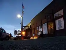 J.A. Bookman General Store |
September 2, 1994 (#94001067) |
Main St. 46°34′39″N 107°22′24″W |
Ingomar | |
| 5 | Brotherhood of Locomotive Engineers Hall | February 12, 1990 (#90000086) |
262 S. 7th Ave. 46°15′42″N 106°40′49″W |
Forsyth | ||
| 6 | Cold Springs Ranch House | January 26, 1990 (#89002347) |
U.S. Route 12, W. 46°16′46″N 106°43′09″W |
Forsyth | ||
| 7 | Deer Medicine Rocks | 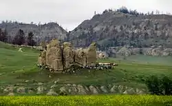 Deer Medicine Rocks |
March 12, 2012 (#12000244) |
45°41’32”N 106°41’45”W Coordinates missing |
Lame Deer vicinity | |
| 8 | First Presbyterian Church and Manse | February 12, 1990 (#90000089) |
1160-1180 Cedar St. 46°16′03″N 106°40′32″W |
Forsyth | ||
| 9 | Forsyth Bridge | February 12, 1990 (#90000090) |
3rd Ave. at the Yellowstone River 46°16′00″N 106°41′28″W |
Forsyth | Pennsylvania truss span over the Yellowstone River; the one surviving span out of three which comprised the first bridge connecting Rosebud County's northern and southern sections. County was formed out of Custer County partly to ensure this bridge would be built. | |
| 10 | Forsyth Main Street Historic District | 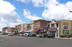 Forsyth Main Street Historic District |
February 12, 1990 (#90000081) |
Roughly bounded by Cedar St., 11th Ave., Main St., and 8th St. 46°15′57″N 106°40′42″W |
Forsyth | |
| 11 | Forsyth Residential Historic District | February 12, 1990 (#90000082) |
Roughly bounded by Cedar St., 11th Ave., Willow St., 12th Ave., Oak St., and 14th Ave. 46°16′11″N 106°40′35″W |
Forsyth | ||
| 12 | Forsyth Water Pumping Station | February 12, 1990 (#90000087) |
3rd Ave. at the Yellowstone River 46°15′58″N 106°41′23″W |
Forsyth | ||
| 13 | Howard School | December 23, 2004 (#04001381) |
Old Montana Highway 10 46°16′12″N 106°53′58″W |
Forsyth | ||
| 14 | Ingomar Public School | September 2, 1994 (#94001068) |
2nd Ave. 46°34′38″N 107°22′17″W |
Ingomar | ||
| 15 | Claude O. Marcyes House | February 12, 1990 (#90000088) |
390 S. 7th Ave. 46°15′38″N 106°40′45″W |
Forsyth | ||
| 16 | Rosebud County Courthouse | 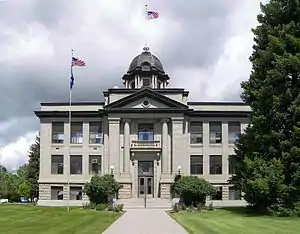 Rosebud County Courthouse |
April 17, 1986 (#86000807) |
1250 Main St. 46°16′04″N 106°40′28″W |
Forsyth | |
| 17 | Rosebud County Deaconess Hospital | November 16, 1979 (#79001425) |
N. 17th Ave 46°16′17″N 106°40′10″W |
Forsyth | ||
| 18 | St. Philip's Episcopal Church | 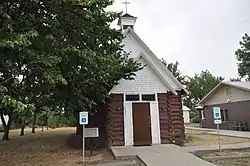 St. Philip's Episcopal Church |
November 20, 2007 (#07001232) |
701 Main St. 46°16′33″N 106°26′24″W |
Rosebud | |
| 19 | Vananda Historic District | 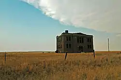 Vananda Historic District |
April 19, 1990 (#90000629) |
U.S. Route 12, 17 miles west of Forsyth 46°23′29″N 107°00′07″W |
Forsyth | |
| 20 | Wiley, Clark & Greening Bank | September 2, 1994 (#94001069) |
Main St. 46°34′39″N 107°22′24″W |
Ingomar | ||
| 21 | Wolf Mountains Battlefield-Where Big Crow walked Back and Forth | 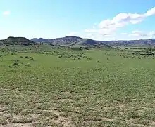 Wolf Mountains Battlefield-Where Big Crow walked Back and Forth |
January 10, 2001 (#00001617) |
About four miles southwest of Birney, along the Tongue River[5] 45°17′18″N 106°34′53″W |
Birney |
See also
| Wikimedia Commons has media related to National Register of Historic Places in Rosebud County, Montana. |
References
- The latitude and longitude information provided in this table was derived originally from the National Register Information System, which has been found to be fairly accurate for about 99% of listings. Some locations in this table may have been corrected to current GPS standards.
- "National Register of Historic Places: Weekly List Actions". National Park Service, United States Department of the Interior. Retrieved on January 29, 2021.
- Numbers represent an alphabetical ordering by significant words. Various colorings, defined here, differentiate National Historic Landmarks and historic districts from other NRHP buildings, structures, sites or objects.
- The eight-digit number below each date is the number assigned to each location in the National Register Information System database, which can be viewed by clicking the number.
- Location and coordinates are derived from its National Historic Landmark nomination, pages 3 and 4; the NRIS lists it as "Address Restricted"
| Topics | |
|---|---|
| Lists by state |
|
| Lists by insular areas | |
| Lists by associated state | |
| Other areas | |
| Related | |
| |
Municipalities and communities of Rosebud County, Montana, United States | ||
|---|---|---|
| Cities | Rosebud County map | |
| CDPs | ||
| Other unincorporated communities | ||
| Indian reservation | ||
| Ghost town | ||
| Footnotes | ‡This populated place also has portions in an adjacent county or counties | |
| ||
This article is issued from Wikipedia. The text is licensed under Creative Commons - Attribution - Sharealike. Additional terms may apply for the media files.