National Register of Historic Places listings in St. Bernard Parish, Louisiana
This is a list of the National Register of Historic Places listings in St. Bernard Parish, Louisiana.
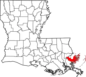
Location of St. Bernard Parish in Louisiana
This is intended to be a complete list of the properties on the National Register of Historic Places in St. Bernard Parish, Louisiana, United States. The locations of National Register properties for which the latitude and longitude coordinates are included below, may be seen in a map.[1]
There are 12 properties listed on the National Register in the parish.
- This National Park Service list is complete through NPS recent listings posted January 29, 2021.[2]
Current listings
| [3] | Name on the Register | Image | Date listed[4] | Location | City or town | Description |
|---|---|---|---|---|---|---|
| 1 | 1939 St. Bernard Parish Courthouse | January 31, 2019 (#100003376) |
1101 W. St. Bernard Hwy. 29°56′24″N 89°58′27″W |
Chalmette | ||
| 2 | Chalmette Unit of Jean Lafitte National Historical Park |  Chalmette Unit of Jean Lafitte National Historical Park |
October 15, 1966 (#66000889) |
6 miles (9.7 km) south of New Orleans 29°56′31″N 89°59′26″W |
Chalmette | Site of the 1815 Battle of New Orleans; park includes monument, visitor center, and national cemetery. |
| 3 | Chandeleur Light |  Chandeleur Light |
June 25, 1986 (#86001404) |
Breton National Wildlife Refuge 30°02′52″N 88°52′18″W |
Chandeleur Islands, Gulf of Mexico | Lighthouse dating from 1848, destroyed by Hurricane Katrina in 2005. |
| 4 | Dr. Louis A. Ducros House | 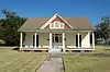 Dr. Louis A. Ducros House |
June 9, 2014 (#14000315) |
1345 Bayou Ave. 29°52′05″N 89°51′37″W |
St. Bernard | |
| 5 | Ford Motor Company Assembly Plant | 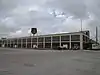 Ford Motor Company Assembly Plant |
June 22, 2018 (#100002589) |
7200 N Peters St. 29°56′47″N 90°00′17″W |
Arabi | |
| 6 | Fort Proctor | Fort Proctor |
September 20, 1978 (#78003067) |
North of Shell Beach on Lake Borgne 29°52′02″N 89°40′42″W |
Shell Beach | Ruins of a mid-19th century fortification intended for the defense of New Orleans; built on the land adjacent to Lake Borgne, it has been surrounded by water since the mid-20th century. |
| 7 | Friscoville Street Historic District |  Friscoville Street Historic District |
July 9, 1998 (#98000837) |
100-900 blocks of Friscoville St. 29°57′01″N 90°00′04″W |
Arabi | |
| 8 | Kenilworth Plantation House | 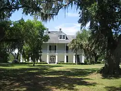 Kenilworth Plantation House |
April 24, 2006 (#06000317) |
2931 Bayou Rd. 29°52′02″N 89°48′51″W |
St. Bernard | Circa-1820 antebellum plantation home; built in the French Creole architectural style, it is one of the few remaining and best-preserved examples. |
| 9 | Magnolia Mound | May 22, 1978 (#78003068) |
Address Restricted |
St. Bernard | ||
| 10 | Old Arabi Historic District | 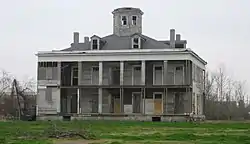 Old Arabi Historic District |
July 9, 1998 (#98000836) |
Roughly along parts of Angela, Mehle, and Esteban Sts. 29°57′06″N 90°00′28″W |
Arabi | |
| 11 | Pecan Grove Plantation House | March 20, 2013 (#13000094) |
10 Pecan Grove Ln. 29°55′44″N 89°55′41″W |
Meraux | ||
| 12 | Sebastopol Plantation House | 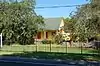 Sebastopol Plantation House |
August 13, 1986 (#86001495) |
Louisiana Highway 46 29°52′04″N 89°52′21″W |
St. Bernard |
See also
References
- The latitude and longitude information provided in this table was derived originally from the National Register Information System, which has been found to be fairly accurate for about 99% of listings. Some locations in this table may have been corrected to current GPS standards.
- "National Register of Historic Places: Weekly List Actions". National Park Service, United States Department of the Interior. Retrieved on January 29, 2021.
- Numbers represent an alphabetical ordering by significant words. Various colorings, defined here, differentiate National Historic Landmarks and historic districts from other NRHP buildings, structures, sites or objects.
- The eight-digit number below each date is the number assigned to each location in the National Register Information System database, which can be viewed by clicking the number.
| Topics | |
|---|---|
| Lists by state |
|
| Lists by insular areas | |
| Lists by associated state | |
| Other areas | |
| Related | |
| |
Municipalities and communities of St. Bernard Parish, Louisiana, United States | ||
|---|---|---|
| CDPs | | |
| Unincorporated communities |
| |
| Ghost towns |
| |
| ||
This article is issued from Wikipedia. The text is licensed under Creative Commons - Attribution - Sharealike. Additional terms may apply for the media files.