National Register of Historic Places listings in Stanley County, South Dakota
This is a list of the National Register of Historic Places listings in Stanley County, South Dakota.
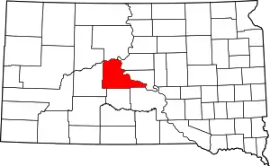
Location of Stanley County in South Dakota
This is intended to be a complete list of the properties on the National Register of Historic Places in Stanley County, South Dakota, United States. The locations of National Register properties for which the latitude and longitude coordinates are included below, may be seen in a map.[1]
There are 12 properties listed on the National Register in the county, including 2 National Historic Landmarks.
- This National Park Service list is complete through NPS recent listings posted January 29, 2021.[2]
Current listings
| [3] | Name on the Register[4] | Image | Date listed[5] | Location | City or town | Description |
|---|---|---|---|---|---|---|
| 1 | American Legion Community Hall | July 31, 2017 (#100001403) |
115 Deadwood St. 44°21′17″N 100°22′17″W |
Fort Pierre | ||
| 2 | Antelope Creek Site (39ST55) | August 14, 1986 (#86002737) |
Address Restricted |
Fort Pierre | ||
| 3 | Bloody Hand Site (39ST230) | August 14, 1986 (#86002736) |
Address Restricted |
Fort Pierre | ||
| 4 | Breeden Village | June 2, 2003 (#03000503) |
Address Restricted |
Fort Pierre | ||
| 5 | Jefferson Davis Carr House | 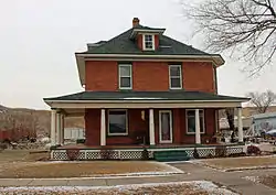 Jefferson Davis Carr House |
March 5, 1982 (#82003942) |
236 W. 2nd Ave. 44°21′17″N 100°22′33″W |
Fort Pierre | |
| 6 | Fort Pierre Chouteau Site | 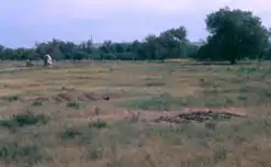 Fort Pierre Chouteau Site |
April 3, 1976 (#76001756) |
North of Fort Pierre 44°23′27″N 100°22′58″W |
Fort Pierre | |
| 7 | Fort Pierre II (39ST217) | August 15, 1988 (#88000732) |
Address Restricted |
Fort Pierre | ||
| 8 | La Verendrye Site | 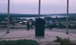 La Verendrye Site |
August 7, 1974 (#74001899) |
Off U.S. Route 83 44°21′19″N 100°22′40″W |
Fort Pierre | |
| 9 | Lower Antelope Creek Site | September 15, 1982 (#82003943) |
Address Restricted |
Fort Pierre | ||
| 10 | Old Fort Pierre School | 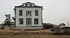 Old Fort Pierre School |
November 25, 1977 (#77001255) |
2nd Ave. and 2nd St. 44°21′17″N 100°22′31″W |
Fort Pierre | |
| 11 | Stockgrowers Bank Building | 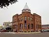 Stockgrowers Bank Building |
November 11, 1977 (#77001256) |
Deadwood and Main Sts. 44°21′16″N 100°22′10″W |
Fort Pierre | |
| 12 | Gaylord Sumner House | 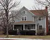 Gaylord Sumner House |
December 21, 1977 (#77001257) |
2nd and Wandel Sts. 44°20′52″N 100°22′15″W |
Fort Pierre | |
| 13 | United Church of Christ, Congregational | 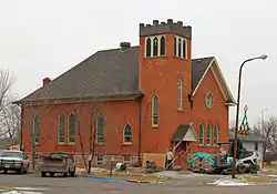 United Church of Christ, Congregational |
December 21, 1977 (#77001258) |
2nd and Main St. 44°21′13″N 100°22′29″W |
Fort Pierre |
See also
| Wikimedia Commons has media related to National Register of Historic Places in Stanley County, South Dakota. |
References
- The latitude and longitude information provided in this table was derived originally from the National Register Information System, which has been found to be fairly accurate for about 99% of listings. Some locations in this table may have been corrected to current GPS standards.
- "National Register of Historic Places: Weekly List Actions". National Park Service, United States Department of the Interior. Retrieved on January 29, 2021.
- Numbers represent an alphabetical ordering by significant words. Various colorings, defined here, differentiate National Historic Landmarks and historic districts from other NRHP buildings, structures, sites or objects.
- "National Register Information System". National Register of Historic Places. National Park Service. April 24, 2008.
- The eight-digit number below each date is the number assigned to each location in the National Register Information System database, which can be viewed by clicking the number.
| Topics | |
|---|---|
| Lists by state |
|
| Lists by insular areas | |
| Lists by associated state | |
| Other areas | |
| Related | |
| |
Municipalities and communities of Stanley County, South Dakota, United States | ||
|---|---|---|
| City | Stanley County map | |
| Unincorporated communities | ||
| Indian reservations | ||
| Ghost towns | ||
| Footnotes | ‡This populated place also has portions in an adjacent county or counties | |
| ||
This article is issued from Wikipedia. The text is licensed under Creative Commons - Attribution - Sharealike. Additional terms may apply for the media files.