National Register of Historic Places listings in Washington County, Nebraska
This is a list of the National Register of Historic Places listings in Washington County, Nebraska.
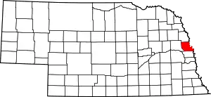
Location of Washington County in Nebraska
This is intended to be a complete list of the properties and districts on the National Register of Historic Places in Washington County, Nebraska, United States. The locations of National Register properties and districts for which the latitude and longitude coordinates are included below, may be seen in a map.[1]
There are 16 properties and districts listed on the National Register in the county, including 1 National Historic Landmark.
- This National Park Service list is complete through NPS recent listings posted January 29, 2021.[2]
Current listings
| [3] | Name on the Register[4] | Image | Date listed[5] | Location | City or town | Description |
|---|---|---|---|---|---|---|
| 1 | Bertrand Site | 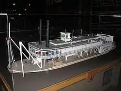 Bertrand Site |
March 24, 1969 (#69000138) |
DeSoto National Wildlife Refuge 41°31′24″N 96°01′44″W |
Blair | |
| 2 | Blair High School | Blair High School |
March 14, 1991 (#91000300) |
Junction of 16th and Colfax Sts. 41°32′24″N 96°08′10″W |
Blair | |
| 3 | Abraham Castetter House | 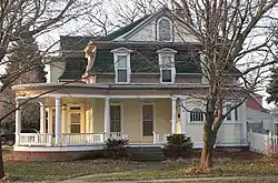 Abraham Castetter House |
June 25, 1982 (#82003203) |
1815 Grant St. 41°32′30″N 96°08′23″W |
Blair | |
| 4 | Congregational Church of Blair | 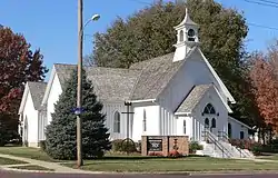 Congregational Church of Blair |
February 1, 1979 (#79001457) |
16th and Colfax Sts. 41°32′27″N 96°08′11″W |
Blair | |
| 5 | C.C. Crowell, Jr. House | 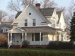 C.C. Crowell, Jr. House |
July 19, 1982 (#82003204) |
2138 Washington St. 41°32′39″N 96°08′42″W |
Blair | |
| 6 | Engineer Cantonment |  Engineer Cantonment |
November 17, 2015 (#15000795) |
Address restricted[6] |
Fort Calhoun | |
| 7 | Fontanelle Township Hall | 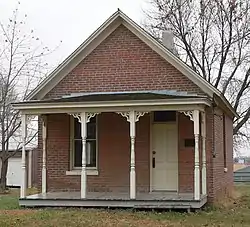 Fontanelle Township Hall |
September 9, 1982 (#82003205) |
10976 8th Street[7] 41°32′14″N 96°25′40″W |
Fontanelle | |
| 8 | Fort Atkinson | 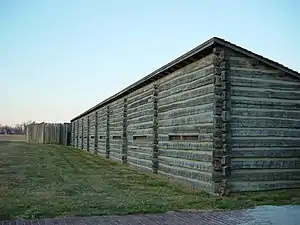 Fort Atkinson |
October 15, 1966 (#66000454) |
1 mile east of Fort Calhoun 41°27′23″N 96°00′49″W |
Fort Calhoun | |
| 9 | Alfred H. and Sarah Frahm House | 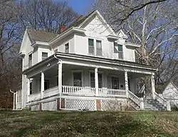 Alfred H. and Sarah Frahm House |
March 2, 2006 (#06000101) |
220 S. 15th St. 41°27′14″N 96°01′41″W |
Fort Calhoun | |
| 10 | Gottsch Farmstead | August 8, 2016 (#16000516) |
17201 Dutch Hall Rd. 41°23′35″N 96°11′02″W |
Bennington | ||
| 11 | Long Creek School | 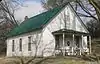 Long Creek School |
February 23, 2001 (#01000167) |
Long Creek Lane 41°27′33″N 96°05′15″W |
Blair | |
| 12 | George A. Marshall House | November 5, 2018 (#100003096) |
301 N 8th St. 41°27′09″N 96°21′28″W |
Arlington | ||
| 13 | Old McDonald Farm | 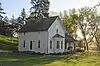 Old McDonald Farm |
July 5, 2001 (#01000714) |
2 miles (3.2 km) south of Blair above Mill Creek[8] 41°30′01″N 96°08′00″W |
Blair | |
| 14 | Frank Parker Archeological Site | March 4, 2009 (#09000069) |
Address restricted[6] |
Fort Calhoun | Extends into Douglas County[4] | |
| 15 | Trinity Seminary Building | July 3, 1980 (#80004528) |
College Dr. 41°33′02″N 96°08′39″W |
Blair | Destroyed by fire in August 1988[9] | |
| 16 | Washington County Courthouse | 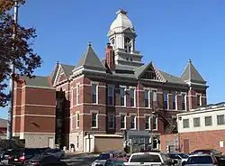 Washington County Courthouse |
January 10, 1990 (#89002221) |
16th St. between Colfax and South Sts. 41°32′24″N 96°08′06″W |
Blair |
Former listings
| [3] | Name on the Register | Image | Date listed | Date removed | Location | City or town | Summary |
|---|---|---|---|---|---|---|---|
| 1 | Crowell Mansion | 1971 (#71001085) | 1971 | 245 S. 22nd St. 33°26′41″N 112°03′54″W |
Blair | Demolished in 1971 |
See also
| Wikimedia Commons has media related to National Register of Historic Places in Washington County, Nebraska. |
References
- The latitude and longitude information provided in this table was derived originally from the National Register Information System, which has been found to be fairly accurate for about 99% of listings. Some locations in this table may have been corrected to current GPS standards.
- "National Register of Historic Places: Weekly List Actions". National Park Service, United States Department of the Interior. Retrieved on January 29, 2021.
- Numbers represent an alphabetical ordering by significant words. Various colorings, defined here, differentiate National Historic Landmarks and historic districts from other NRHP buildings, structures, sites or objects.
- "National Register Information System". National Register of Historic Places. National Park Service. April 24, 2008.
- The eight-digit number below each date is the number assigned to each location in the National Register Information System database, which can be viewed by clicking the number.
- Federal and state laws and practices restrict general public access to information regarding the specific location of this resource. In some cases, this is to protect archeological sites from vandalism, while in other cases it is restricted at the request of the owner. See: Knoerl, John; Miller, Diane; Shrimpton, Rebecca H. (1990), Guidelines for Restricting Information about Historic and Prehistoric Resources, National Register Bulletin, National Park Service, U.S. Department of the Interior, OCLC 20706997.
- "Hot Dogs At The Town Hall". Washington County Museum Quarterly Newsletter. Spring 2007. Retrieved 2015-12-13.
- Stupka-Burda, Stacy. National Register of Historic Places Inventory/Nomination: Old McDonald Farm. National Park Service, 2001-04-17, 5.
- "Landmarks in Washington County, Nebraska". Archived 2008-03-31 at the Wayback Machine Washington County Historical Association. Archived 2010-05-26 at the Wayback Machine Retrieved 2010-10-27.
| Topics | |
|---|---|
| Lists by state |
|
| Lists by insular areas | |
| Lists by associated state | |
| Other areas | |
| Related | |
| |
Municipalities and communities of Washington County, Nebraska, United States | ||
|---|---|---|
| Cities | Map of Nebraska highlighting Washington County | |
| Villages | ||
| Townships | ||
| CDP | ||
| Unincorporated communities | ||
| Former community | ||
| Footnotes | ‡This populated place also has portions in an adjacent county or counties | |
| ||
This article is issued from Wikipedia. The text is licensed under Creative Commons - Attribution - Sharealike. Additional terms may apply for the media files.