National Register of Historic Places listings in Wilkinson County, Mississippi
This is a list of the National Register of Historic Places listings in Wilkinson County, Mississippi.
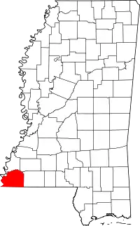
Location of Wilkinson County in Mississippi
This is intended to be a complete list of the properties and districts on the National Register of Historic Places in Wilkinson County, Mississippi, United States. Latitude and longitude coordinates are provided for many National Register properties and districts; these locations may be seen together in a map.[1]
There are 16 properties and districts listed on the National Register in the county.
- This National Park Service list is complete through NPS recent listings posted January 29, 2021.[2]
Current listings
| [3] | Name on the Register[4] | Image | Date listed[5] | Location | City or town | Description |
|---|---|---|---|---|---|---|
| 1 | Anderson Mound | May 1, 1986 (#86000921) |
Address Restricted |
Woodville | ||
| 2 | Arbuthnot's Grocery and House | May 20, 2016 (#16000284) |
8990 Pinckneyville Rd. 31°05′47″N 91°26′44″W |
Woodville | ||
| 3 | Branch Banking House |  Branch Banking House |
March 30, 1978 (#78001635) |
Bank St. 31°06′10″N 91°17′57″W |
Woodville | Currently known as the Wilkinson County African-American Museum |
| 4 | Centreville Historic District | October 13, 1992 (#92001091) |
Roughly bounded by Cherokee, Laurel, and St. Mary Sts. 31°05′12″N 91°04′06″W |
Centreville | ||
| 5 | Desert Plantation | April 1, 1987 (#87000543) |
East of Pinckneyville-Woodville Rd. 31°01′37″N 91°28′33″W |
Woodville | ||
| 6 | Forest Home Plantation | March 19, 1982 (#82003121) |
Southwest of Centreville 31°00′34″N 91°11′53″W |
Centreville | ||
| 7 | Fort Adams Site | January 11, 1974 (#74001067) |
South of Fort Adams 31°04′46″N 91°32′51″W |
Fort Adams | ||
| 8 | Hampton Hall | October 24, 1980 (#80002307) |
U.S. Highway 61 31°05′40″N 91°17′30″W |
Woodville | ||
| 9 | Holly Grove | October 21, 1988 (#88002037) |
Mississippi Highway 33, 4 miles south of Mississippi Highway 24 31°02′23″N 91°06′09″W |
Centreville | ||
| 10 | Office and Banking House of West Feliciana Railroad | October 28, 1977 (#77000798) |
Depot St. 31°06′10″N 91°17′54″W |
Woodville | ||
| 11 | Pleasant Hill | November 17, 1982 (#82000582) |
East of Woodville on Mississippi Highway 24 31°05′27″N 91°15′35″W |
Woodville | ||
| 12 | Rosemont | 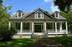 Rosemont |
December 30, 1974 (#74001068) |
East of Woodville on Mississippi Highway 24 31°06′02″N 91°16′31″W |
Woodville | Also known as Poplar Grove or the Hale House |
| 13 | Salisbury Plantation | June 16, 1983 (#83000970) |
Off Woodville Rd. 31°03′28″N 91°26′39″W |
Woodville | ||
| 14 | Smith Creek Site | June 13, 1978 (#78001634) |
Address Restricted |
Fort Adams | ||
| 15 | Tansy Island Hunting Club Camp Site and Clubhouse | March 3, 1995 (#95000179) |
Tansy Island Rd., off of Dolosoro Loop 31°16′02″N 91°23′31″W |
Woodville | ||
| 16 | Woodville Historic District | 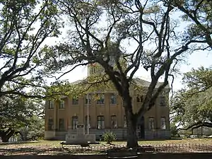 Woodville Historic District |
September 30, 1982 (#82003122) |
Roughly bounded by Prentiss, 2nd, College, Siglo, and Water Sts.; also 546 Depot St. and 559 3rd St.; also roughly along Depot, 1st West, Main, 2nd South, Sligo, 3rd South, and Water Sts.; also roughly bounded by the Old Prentiss Highway, U.S. Route 61, and the city limits 31°06′07″N 91°17′56″W |
Woodville | Boundaries after the first semicolon represent boundary increases of October 21, 1993, May 20, 1999, and October 19, 2001 |
See also
| Wikimedia Commons has media related to National Register of Historic Places in Wilkinson County, Mississippi. |
References
- The latitude and longitude information provided in this table was derived originally from the National Register Information System, which has been found to be fairly accurate for about 99% of listings. Some locations in this table may have been corrected to current GPS standards.
- "National Register of Historic Places: Weekly List Actions". National Park Service, United States Department of the Interior. Retrieved on January 29, 2021.
- Numbers represent an alphabetical ordering by significant words. Various colorings, defined here, differentiate National Historic Landmarks and historic districts from other NRHP buildings, structures, sites or objects.
- "National Register Information System". National Register of Historic Places. National Park Service. March 13, 2009.
- The eight-digit number below each date is the number assigned to each location in the National Register Information System database, which can be viewed by clicking the number.
| Topics | |
|---|---|
| Lists by state |
|
| Lists by insular areas | |
| Lists by associated state | |
| Other areas | |
| Related | |
| |
Municipalities and communities of Wilkinson County, Mississippi, United States | ||
|---|---|---|
| Towns | Map of Mississippi highlighting Wilkinson County | |
| Unincorporated communities | ||
| Ghost towns | ||
| Footnotes | ‡This populated place also has portions in an adjacent county or counties | |
| ||
This article is issued from Wikipedia. The text is licensed under Creative Commons - Attribution - Sharealike. Additional terms may apply for the media files.