Long-distance trails in the United States
This is a list of long-distance trails in the United States:
| Name | Length | Region | Endpoint 1 | Endpoint 2 | Description | |
|---|---|---|---|---|---|---|
| mi | km | |||||
| Allegheny Trail | 287.81[1] | 463.19 | West Virginia | Appalachian Trail | Mason–Dixon line | West Virginia through the Appalachian Mountains and Allegheny Mountains |
| American Discovery Trail | 6,800[2] | 10,900 approx. | Coast-to-Coast | Cape Henlopen State Park, Delaware | Point Reyes National Seashore, California | Passes through Delaware, Maryland, West Virginia, Ohio, Kentucky (Southern Route), Indiana, Illinois, Iowa (Northern Route), Nebraska (Northern Route), Missouri (Southern Route), Kansas (Southern Route), Colorado, Utah, Nevada, and California. The northern route is 4,834 miles and the southern 5,057. [3] |
| Appalachian Trail | 2,189.1 | 3,523.0 | Appalachian Mountains | Georgia | Maine | passes through North Carolina, Tennessee, Virginia, West Virginia, Maryland, Pennsylvania, New Jersey, New York, Connecticut, Massachusetts, Vermont, and New Hampshire |
| Arizona Trail | 825.2[4] | 1,328.0 | Arizona | Coronado National Memorial in Hereford, Arizona (at the United States-Mexico border) | Stateline Campground, Kanab, Utah | Designated a National Scenic Trail in 2009. |
| Backbone Trail | 68 | 109 | Santa Monica Mountains NW of Los Angeles, California | Point Mugu State Park | Will Rogers State Historic Park | traverses Santa Monica Mountains, limited overnight capacity |
| Baker Trail | 132 | 212 | Pennsylvania | Allegheny National Forest | Allegheny Township | A hiking trail in Pennsylvania. |
| Bartram Trail | 153 | 246 | Southeast Appalachian mountains | Chattooga River | Cheoah Bald | connects to the Appalachian and Foothills Trails; traverses Georgia and North Carolina |
| Batona Trail | 49.5 | 79.7 | New Jersey Pinelands National Reserve | Ong's Hat | Bass River State Forest | Passes through three state parks in the heart of the New Jersey Pine Barrens |
| Bay Area Ridge Trail | 390[5] | 630 | San Francisco Bay Area | circles San Francisco Bay; under development | ||
| Bay Circuit Trail & Greenway | 230[6] | 370 | Massachusetts | Newbury, Massachusetts | Kingston, Massachusetts | under construction; will circumnavigate Massachusetts Bay |
| Benton MacKaye Trail | 287.6[7] | 462.8 | Southern Appalachian Mountains | Springer Mountain in Georgia | Big Creek, north of Mount Sterling [8] | connects from the southern terminus of the Appalachian Trail; traverses Georgia, Tennessee, and North Carolina. Both endpoints meet with the Appalachian Trail. Together, the two trails form a figure-8 loop. |
| Bigfoot Trail | 356.51[9] | 573.75 | Northwest California and southwest Oregon | Yolla Bolly-Middle Eel Wilderness | Redwood National and State Parks near Crescent City, California | |
| Black Forest Trail | 42[10] | 68 | North-Central Pennsylvania | loop near Slate Run, Pennsylvania | ||
| Bonneville Shoreline Trail | 90 | 140 | Utah | circles ancient Lake Bonneville | ||
| Border Route Trail | 65 | 105 | Boundary Waters Canoe Area Wilderness | Follows the ridgeline above the chain of lakes along the international border between Minnesota and Ontario, Canada and is known for its dramatic vistas. | ||
| Buckeye Trail | 1,444 | 2,324 | Ohio | Lake Erie at Headlands Beach State Park | Eden Park in Cincinnati | circles Ohio; many scenic locations, such as the Hocking Hills region and the Cuyahoga Valley National Park; passes through many small historical towns, shares path with American Discovery Trail and North Country Trail |
| California Coastal Trail | 1,200 | 1,900 | California | Oregon | Mexico | more than half complete as of June 2012; within sight, sound, or at least the scent of the sea |
| Caprock Canyons Trailway | 68 | 109 | Texas | South Plains Terminal MM | Estelline Terminal MM | A rail trail in Caprock Canyons State Park 100 miles (160 km) southeast of Amarillo, Texas Open to hikers, bikers, and horseback riders. |
| Catamount Trail | 300 | 480 | Vermont | Readsboro, Vermont | Canada–US border in North Troy, Vermont | A cross-country skiing trail which crosses the state of Vermont. Parts of the trail are only open in the winter. |
| Centennial Trail (in the Black Hills of South Dakota) | 111[11] | 179 | South Dakota | Wind Cave National Park | Bear Butte | |
| Conestoga Trail | 63 | 101 | Lancaster County, Pennsylvania | Horse-Shoe Trail | Mason-Dixon Trail | A trail that stretches across Lancaster County, Pennsylvania. |
| Chief Ladiga Trail | 33 | 53 | Alabama | Georgia state line | Weaver | Alabama's longest rails-to-trails project, at the state line it turns into Georgia's Silver Comet Trail |
| Chilkoot Trail | 33 | 53 | Yukon | Dyea, Alaska | Bennett, British Columbia | international historical trail; late 1890s major access route between the coast and Yukon goldfields |
| C&O Canal Trail | 184.5 | 296.9 | Maryland | Cumberland | Washington, DC | trail is the old towpath for the abandoned Chesapeake and Ohio Canal along the Potomac River |
| Coast to Crest Trail | 70 | 110 | California | Pacific Ocean at Del Mar | Volcan Mountains near Julian | The main east-west trail of the San Dieguito River Park, the trail follows the San Dieguito River from the ocean to the river's source. As of 20121, 66% of the planned 70 miles of trail have been completed.[12] |
| Cohos Trail | 162 | 261 | Northern New Hampshire | Notchland, near Crawford Notch State Park | Canada–US border at the southern edge of Quebec | |
| Colorado Trail | 483 | 777 | Central Colorado | Waterton Canyon southwest of Denver | Durango | completed in 1987; highest point 13,334 ft (4,064 m); most above 10,000 ft (3,000 m); often dips below the alpine timberline |
| Condor Trail | 400 | 640 | California | Lake Piru | Bottcher's Gap | Los Padres National Forest, under development |
| Continental Divide Trail | 3,100 | 5,000 | Rocky Mountains | Glacier National Park, Montana at the U.S.–Canada border | Big Hatchet Mountains, New Mexico at the U.S.–Mexico border | on or near the Continental Divide; 70% complete as of 2007; crosses Triple Divide Peak |
| Corvallis to the Sea Trail | 62 | 100 | Western Oregon | Corvallis, Oregon | Ona Beach | eastern half opened September 2017; western half expected to be officially open in two years |
| Cowboy Trail | 195 | 314 | Northern Nebraska | Norfolk, Nebraska | Valentine, Nebraska | started in 1996, a multi-use rail trail. 321 miles (517 km) of former rail right-of-way, if completed may create the longest rail trail. |
| Cranberry Lake 50 | 50 | 80 | New York | circles the shores of Cranberry Lake in the Northwestern region of the Adirondack Park | ||
| Cumberland Trail | 175 | 282 | Tennessee | trail along the Cumberland Plateau | ||
| Des Plaines River Trail | 55 | 89 | Northern Illinois | Wisconsin state line | North Avenue in Melrose Park, Chicago | short stretches incomplete |
| Desert Trail | 2,223 | 3,578 | Desert and mountains of the West | Jacumba, California | Snowy Top, Canada border | Traverses the Mojave Desert, Death Valley, the Black Rock Desert, Pueblo Mountains, Blue Mountains, Columbia Plateau, and Selkirk Mountains. |
| Donut Hole Trail | 81 | 130 | Sproul State Forest | hiking trail in Pennsylvania | ||
| Duncan Ridge Trail | 35.5 | 57.1 | Chattahoochee National Forest | Appalachian & Benton MacKaye Trails at Three Forks | Appalachian Trail at Slaughter Mountain | A National Recreation Trail which forms a 60-mile (97 km) loop in combination with the Appalachian Trail. |
| East Coast Greenway | 3,000 | 4,800 | Eastern U.S. | Calais, Maine | Key West, Florida | 29% complete as of 2013, multi-use path |
| Eastern Continental Trail | 5,400 | 8,700 | Eastern U.S. | Key West, Florida | Belle Isle, Newfoundland | mountain route to Labrador, Canada |
| Erie Canalway Trail | 360 | 580 | New York | Buffalo, New York | Albany, New York | Mostly flat, multi-use trail and on-road segments[13] |
| Finger Lakes Trail | 557.7 | 897.5 | New York | Catskills | Western New York | Footpath: Main Trail from Allegany State Park to Catskills plus additional six branch trails. Traverses NYS along southern counties. Est. 1962 |
| Flint Hills Nature Trail | 117 | 188 | Kansas | Osawatomie, Kansas | Herington, Kansas | Rail-trail in eastern Kansas. |
| Florida Trail | 1,000 | 1,600 | Florida | Gulf Islands National Seashore | Big Cypress National Preserve | up to 1,300 miles (2,100 km) total length is planned; construction began in 1966; designated a National Scenic Trail in 1983 |
| Fonta Flora State Trail | 100 | 160 | North Carolina | Asheville | Morganton | Developing hiking and cycling loop trail around Lake James with spurs to Asheville and Morganton. |
| Foothills Trail | 76 | 122 | Appalachian foothills | Table Rock State Park | Oconee State Park | Follows the Blue Ridge Escarpment in South Carolina, and partly in North Carolina. |
| Fox River Trail (Illinois) | 44 | 71 | Northern Illinois | Algonquin, Illinois | Oswego, Illinois | |
| Fox River State Recreational Trail | 26.3 | 42.3 | NE Wisconsin | downtown Green Bay | Hilbert | northern 12 miles (19 km) paved, southern 14 miles (23 km) gravel |
| Gabrielino Trail | 28.8 | 46.3 | Southern California | Altadena, California | Chantry Flat, just north of Arcadia, California | National Recreation Trail in the Angeles National Forest |
| Gandy Dancer State Trail | 98.1[14] | 157.9 | Wisconsin and Minnesota | St. Croix Falls, Wisconsin | Superior, Wisconsin | hiking and biking path |
| George S. Mickelson Trail | 108.8 | 175.1 | South Dakota | within the Black Hills | ||
| Ghost Town Trail | 36 | 58 | Western Pennsylvania | Ebensburg, Pennsylvania | Black Lick, Indiana County | A National Recreation Trail in Western Pennsylvania. |
| Good Water Loop | 26.9 | 43.3 | Texas | Georgetown, Texas | A loop around Lake Georgetown, maintained by the U.S. Army Corps of Engineers | |
| Grand Enchantment Trail | 730 | 1,170 | Southwest desert | Phoenix, Arizona | Albuquerque, New Mexico | east-west mostly wilderness trail |
| Great Allegheny Passage | 150 | 240 | Northeast | A rail trail in Maryland and Pennsylvania. | ||
| Great Eastern Trail | 1,600 | 2,600 approx. | Eastern U.S. | New York | Alabama | in development with portions open |
| Great Miami River Trail | 76[15] | 122 | Ohio | Franklin, Ohio | Piqua, Ohio | multi-use path along the Great Miami River |
| Great River Trail | 60 | 97 | Northern Illinois | Rock Island, Illinois | Savanna, Illinois | in development with most open |
| Great Western Loop | 6,875 | 11,064 | Western United States | Grand Canyon | Grand Canyon | loop of the U.S. west combining the Pacific Crest Trail, Pacific Northwest Trail, Continental Divide Trail and other trails.[16] |
| Great Western Trail | 4,455 | 7,170 | Western Rockies | Canada | Mexico | passes through Arizona, Idaho, Montana, Utah, and Wyoming |
| Great Western Trail (Illinois) | 92 | 148 | Illinois, Iowa | mostly rails to trails conversion | ||
| Green Bay Trail-Robert McClory Trail-Kenosha County Bike Path | 36 | 58 | Southern Wisconsin and Northern Illinois | Wilmette, Illinois | Pleasant Prairie, Wisconsin | |
| Greenstone Ridge Trail | 40 | 64 | Isle Royale National Park | Windigo Ranger Station | Rock Harbor, Michigan | Backbone trail of Isle Royale |
| Hayduke Trail | 812 | 1,307 | Utah and Arizona | route in Utah and Arizona, linking Zion, Grand Canyon, Bryce Canyon, Capitol Reef, Canyonlands, and Arches National Parks | ||
| Hennepin Canal Parkway | 105 | 169 | Northern Illinois | Bureau Junction, Illinois | Colona, Illinois | |
| Hickory Nut Gorge State Trail | 130 | 210 | North Carolina | Developing figure-8 loop trail around Hickory Nut Gorge and Lake Lure. | ||
| High Country Pathway | 70[17] | 110 | Michigan | Loop through the Pigeon River Country State Forest near Vanderbilt, Michigan | ||
| High Line Canal Trail | 58 | 93 | Colorado | Waterton Canyon, Chatfield State Park | Aurora, Colorado | Mostly unpaved trail along the High Line Canal waterway through metropolitan Denver, Colorado |
| High Sierra Trail | 61.5 | 99.0 | California | Crescent Meadow in Sequoia National Park | Mount Whitney | |
| Highlands Trail | 125.57[18] | 202.09 | New York and New Jersey | Storm King Mountain | Delaware Water Gap | |
| Highline National Recreation Trail | 54.8 | 88.2 | Arizona | Pine, Arizona | Close to where Arizona State Route 260 intersects Mogollon Rim | Historic trail established in the late 1800s to link various homesteads and ranches below the Mogollon Rim. |
| Horse Shoe Trail | 140 | 230 | Southeastern Pennsylvania | Valley Forge | Appalachian Trail near Harrisburg | |
| Ice Age Floods National Geologic Trail | ? | ? | Oregon, Washington, Idaho, Montana | proposed trail, possibly only an auto route but likely to have water and hiking trails; authorized in 2009 by US Congress | ||
| Ice Age Trail | 1,200 | 1,900 approx. | Wisconsin | Potawatomi State Park | Interstate Park | generally follows end moraine of the last ice age |
| Idaho Centennial Trail | 883 | 1,421 | Idaho | near Murphy Hot Springs | Upper Priest Falls | Traverses large wilderness areas |
| Iditarod Trail | 1,025 | 1,650 | Alaskan wilderness | Seward | Nome | famous dog sledding race; route alternates each year |
| Illinois & Michigan Canal Trail | 69 | 111 | Northern Illinois | Peru, Illinois | Romeoville, Illinois | |
| Illinois Prairie Path | 61 | 98 | Illinois | Wheaton | second of 27 new National Trails, consists of three radials | |
| International Appalachian Trail | 1,900 | 3,100 approx. | Northeastern North America | Mount Katahdin, Maine | Newfoundland | from the northern terminus of Appalachian Trail; proposals pending to extend to Europe and North Africa |
| Iron Horse Regional Trail | 40 | 64 | San Francisco Bay Area | Concord, California | Pleasanton, California | The completed Iron Horse Regional Trail will span the distance from Livermore to Suisun Bay in Contra Costa County, a distance of 55 miles, connecting two counties and 12 cities. |
| Iron Mountain Trail | 58 | 93 approx. | NE Tennessee and Mount Rogers National Recreation Area, Virginia | Appalachian Trail at Cross Road Mountain, Tennessee | Northwest of Fries, Virginia | Transverses the Iron Mountains; most of the route was part of the Appalachian Trail prior to 1972. Many sections are open to bikes and equestrians. |
| John Muir Trail | 211 | 340 | California Sierra Nevada | Yosemite Valley | Mount Whitney | |
| Jordan River Trail | 40 | 64 | Utah | Great Salt Lake (U.S.) | Utah Lake | winds through city parks and residential areas, mostly paved; an unpaved extension continues another ~26 miles north |
| Katy Trail | 240 | 390 | Missouri | crosses the state | ||
| Kekekabic Trail | 41 | 66 | Superior National Forest, Minnesota | Snowbank Lake Rd near Ely, MN | Gunflint Trail near Grand Marais, MN | A rugged footpath that crosses through the heart of the Boundary Waters Canoe Area Wilderness. |
| Kettle Crest Trail | 44 | 71 | Northeast Washington | Deer Creek Summit Trailhead on Boulder Highway between Curlew and Orient, WA. | White Mountain Trailhead near Kettle Falls, WA. | A National Recreation Trail that is now a part of the Pacific Northwest Trail. It follows the crest of the Kettle Range Mountains and features a half-dozen of some of eastern Washington's highest peaks in one the wildest unprotected areas in the region. |
| Knobstone Trail | 58 | 93 | Southern Indiana | The Knobstone Trail (KT) is Indiana's longest footpath - a 60-mile backcountry-hiking trail passing through Clark State Forest, Elk Creek Public Fishing Area, and Jackson-Washington State Forest. These state resource properties contain more than 42,000 acres of rugged, forested land in Clark, Scott and Washington counties in southern Indiana. The trail extends from Deam Lake, just north of State Road 60 in Clark County, to Delaney Park, just east of S.R. 135 in Washington County. The initial 32-mile segment of the trail was opened in 1980.[19] | ||
| Lake Okeechobee Scenic Trail | 109 | 175 | Florida | part of the Florida Trail | ||
| Laurel Highlands Hiking Trail | 70 | 110 | Southwestern Pennsylvania | trail in the Laurel Highlands area | ||
| Little Miami Scenic Trail | 74.9 | 120.5 | Miami Valley in Ohio | Springfield, Ohio | Newtown, Ohio | Entirely paved trail along the Little Miami River; almost entirely off-road. Continues an additional 32 miles (51 km) north to Bellefontaine as the Simon Kenton Trail. |
| Lone Star Hiking Trail | 96 | 154 | Texas | A few miles East of Richards, Texas | A few miles Northwest of Cleveland, Texas | Traverses east/west through the Sam Houston National Forest north of Houston. A series of intersecting loop trails bring total potential mileage to 132. Heavily forested throughout, the trail skirts many developed areas, and contains a number of road walks (some several miles long) connecting sections of the trail. Trail is blazed, well signed, and regularly maintained along the entire length. |
| Long Path | 347.4 | 559.1 | New York + New Jersey | George Washington Bridge in Fort Lee, New Jersey | Altamont, New York (Albany) | |
| Long Trail | 272 | 438 | Vermont | Massachusetts | Canada | A footpath in the Wilderness begun in 1910 and completed in the 1930s. The Long Trail spans the length of Vermont, following the spine of the Green Mountains. Typical hiking time is 2 to 4 weeks. |
| Loyalsock Trail | 59.2 | 95.3 | North Central Pennsylvania | Pennsylvania Route 87, 10 mi (16 km) north of Montoursville | Meade Road, 0.2 mi (0.3 km) from U.S. Route 220, just north of Laporte | Hiking trail that runs parallel to Lycoming Creek. The trail is maintained by the Alpine Club of Williamsport, Pennsylvania. |
| Maah Daah Hey Trail | 144 | 232 | North Dakota | Theodore Roosevelt National Park | the longest continuous single track mountain biking trail in America | |
| Mark O. Hatfield Memorial Trail | 60 | 97 | Oregon | Starvation Creek | Multnomah Falls | proposed in 2011, almost entirely in wilderness, course incompletely determined as of 2013, but expected to be on existing trails |
| Mason-Dixon Trail | 190 | 310 | Pennsylvania | Appalachian Trail at Whiskey Springs, Pennsylvania | Brandywine Creek at Chadds Ford, Pennsylvania | |
| Massanutten Trail | 71 | 114 | George Washington National Forest | Large loop trail in Central Virginia; National Recreation Trail. | ||
| Mattabesett Trail | 57 | 92 | South-Central Connecticut | |||
| Metacomet-Monadnock Trail | 114 | 183 | New Hampshire | Metacomet Trail on the Massachusetts-Connecticut state line | Mount Monadnock | |
| Michigan Shore-to-Shore Trail | 220 | 350 | Michigan | Lake Michigan | Lake Huron | |
| Midstate Trail (Massachusetts) | 92 | 148 | Massachusetts | Worcester County, central Massachusetts | ||
| Monadnock-Sunapee Greenway | 50 | 80 | Southwest New Hampshire | Mount Monadnock | Mount Sunapee | |
| Mountains-to-Sea Trail | 1,000 | 1,600 approx. | North Carolina | Clingman's Dome, Great Smoky Mountains | Jockey's Ridge, Outer Banks | about 530 miles (850 km) complete as of 2011; follows the Appalachian Trail for 3.4 miles (5.5 km) |
| Natchez Trace Trail | 440 | 710 | Southeastern U.S. | Tennessee | Mississippi | disjoint trail; 62 miles (100 km) complete; not planned to be connected |
| New England Trail | 233 | 375 | Connecticut and Massachusetts | Guilford, Connecticut | New Hampshire border | includes most of the Metacomet-Monadnock Trail, Mattabesett Trail and Metacomet Trail; designated as NST in 2009 |
| New River Trail State Park | 57 | 92 | Southern Virginia | Pulaski, Virginia | Fries, Virginia & Galax, Virginia | A rail trail, with three end points, following the New River and one of its tributaries. |
| North-South Trail (KY/TN) | 59 | 95 | Kentucky/Tennessee | near Grand Rivers, Kentucky | near Dover, Tennessee | Hiking trail running the length of the Land Between the Lakes National Recreation Area. Terrain ranges from easy to moderate. Great lake views in the north and deeper woodlands in the south. Camping shelters every 10-12 miles; off-trail backcountry camping allowed with free permit (obtained at the North Welcome Station, Golden Pond Visitor Center, or the South Welcome Station). Many sites of historical interest on or near the trail. |
| North-South Trail (RI) | 77 | 124 | Rhode Island | Blue Shutters Beach, Charlestown, Rhode Island | Massachusetts border, Burrillville, Rhode Island | A hiking trail that runs the length of Rhode Island from the Atlantic Ocean in Charlestown to the Massachusetts border in Burrillville, Rhode Island where it connects to the Mid-State Trail. |
| North Country Trail | 4,600 | 7,400 | Northern United States | Crown Point, New York | Lake Sakakawea State Park, North Dakota | A diverse footpath crossing the prairies of North Dakota; the Northwoods of Minnesota, Wisconsin, and Michigan; rural farm country of southern Michigan and western Ohio; and the rugged Allegheny Plateau of eastern Ohio, Pennsylvania, and New York; and finally the Finger Lakes region and Adirondacks of New York. |
| North Umpqua Trail | 79 | 127 | Southern Oregon | follows the Umpqua River; 11 segments mostly in undeveloped forest | ||
| Northeast Texas Trail | 132 | 212 | Texas | Farmersville, Texas (NE of Dallas) | New Boston, Texas | incomplete rail to trail conversion which passes through seven rural Texas counties and 19 towns, mostly east-west. There are overgrown and illegally fenced off sections.[20][21][22] |
| Northern Forest Canoe Trail | 740 | 1,190 | Northeastern United States | Old Forge, NY | Fort Kent, ME | Water trail through New York, Vermont, Quebec, New Hampshire, and Maine. |
| Northern Peaks State Trail | 40 | 64 | North Carolina | Boone | Mount Jefferson State Natural Area | Planned hiking trail which will connect several mountain peaks in North-western North Carolina. |
| Northville-Placid Trail | 138.4[23] | 222.7 | New York | Northville | Lake Placid | North-south low-elevation trail through the Adirondack Park (begin 1922, completed 1924). |
| OC&E Woods Line State Trail | 105 | 169 | Oregon | Klamath Falls | Thompson Reservoir | a rail trail and Oregon State Park |
| Ocean to Lake Trail | 63 | 101 | Florida | Hobe Sound Beach on the Atlantic Ocean | Lake Okeechobee | The Ocean to Lake Hiking Trail (OTLHT) runs approx 63 miles west from Hobe Sound Beach to Lake Okeechobee where it ends at the Lake Okeechobee Scenic Trail (LOST) trail head. |
| Ohio to Erie Trail | 318 | 512 | Ohio | Cincinnati on the Ohio River | Cleveland | Incorporates numerous rail trails and roads |
| Old Croton Trail | 26.2 | 42.2 | New York | Van Cortlandt Park, The Bronx | New Croton Dam | follows Old Croton Aqueduct |
| Old Loggers Path | 27.1 | 43.6 | Lycoming County, Pennsylvania | loop trail on former lumber lands in Tiadaghton State Forest in Pennsylvania | ||
| Olympic Discovery Trail | 120 | 190 | Washington state's Olympic Peninsula | Port Townsend | La Push | about 40 miles (64 km) complete as of 2011 with the remainder traversable using public roads |
| Oregon Coast Trail | 362 | 583 | Oregon | North Oregon coast at South Jetty | Brookings | entire Pacific coast of Oregon |
| Oregon Desert Trail | 750 | 1,210 | Oregon | Oregon Badlands Wilderness | Lake Owyhee State Park | under development as of summer 2013, though no trail needs to be built: uses existing trails and public lands |
| Oregon Skyline Trail | 428 | 689 | Oregon | Washington state | California | established in 1920, incorporated into Pacific Crest Trail in 1968; follows Cascades backbone |
| Ouachita National Recreation Trail | 223 | 359 | Arkansas and Oklahoma | longest trail in Ouachita National Forest | ||
| Overmountain Victory National Historic Trail | 214 | 344 | Southeastern United States | Abingdon, Virginia & Elkin, North Carolina | Kings Mountain National Military Park | Y-shaped trail commemorating the historic route of the Overmountain Men. |
| Ozark Highlands Trail | 218 | 351 | Arkansas | through the Ozark National Forest | ||
| Ozark Trail | 350 | 560 approx. | Missouri | |||
| Pacific Crest Trail | 2,654 | 4,271 | West Coast | Mexico | Canada | traverses Sierra Nevada and the Cascade Range paralleling the Pacific Ocean in California, Oregon and Washington |
| Pacific Northwest Trail | 1,200 | 1,900 | Pacific Northwest | Chief Mountain Border Station, Glacier National Park, Montana | Cape Alava, Olympic National Park, Washington | Designated a National Scenic Trail in 2009. |
| Palmetto Trail | 425 | 684 | South Carolina | Charleston | Southern Appalachians | 225 contiguous miles 362 km complete |
| Paumanok Path | 125 | 201 | Long Island, New York | Rocky Point | Montauk Point | Only long-distance trail in the Long Island Central Pine Barrens |
| Pend Oreille River Water Trail | 70 | 110 | Pend Oreille County, Washington | Oldtown, Idaho | Boundary Dam, Washington | This water trail traverses the Pend Oreille River, one of the few rivers in the US that flows north. The trail goes from the Washington/Idaho border through several communities, the Kalispel Indian Reservation, through rural Pend Oreille County, north to waterfalls, a 10-mile canyon, and opportunities to see wildlife. |
| Pennsylvania Mid State Trail | 327 | 526 | Pennsylvania | Maryland | New York | traverses width of state |
| Pinhoti Trail | 335 | 539 | Alabama and Georgia | Benton MacKaye Trail | Flagg Mountain near Weogulfa, Alabama | Connects the Appalachian Trail to the southernmost mountain of the Appalachian Mountain chain that is over 1,000 feet (300 m) in elevation. |
| Potomac Heritage Trail | 830 | 1,340 | mid-northeastern U.S. | incomplete; trail network within Potomac River basin | ||
| Quehanna Trail | 74 | 119 | Pennsylvania | loop trail through Moshannon State Forest and Elk State Forest in North-Central Pennsylvania | ||
| River to River Trail | 162 | 261 | Southern Illinois | Ohio River | Mississippi River | Stretches through Shawnee National Forest. It forms part of the Southern Section of the American Discovery Trail. |
| Robert Frost Trail | 47 | 76 | Massachusetts | Connecticut River Valley | ||
| Rock Island Trail (Illinois) | 32 | 51 | Central Illinois | Peoria, Illinois | Toulon, Illinois | |
| Rock Island Trail (Missouri) | 47 | 76 | Western Missouri | Pleasant Hill, Missouri | Windsor, Missouri | |
| San Diego Trans County Trail | 160 | 260 | California | Salton Sea | Torrey Pines State Natural Reserve | The Salton Sea to Torrey Pines Beach; ROUTE – under development. |
| San Francisco Bay Trail | 500 | 800 | San Francisco Bay Area | encircles shoreline of San Francisco Bay; under development | ||
| San Joaquin River Trail | 73 | 117 | Central California | Friant Dam to Devils Postpile in the High Sierra Nevada Mountain Range; under development | ||
| September 11th National Memorial Trail | 1,000 | 1,600 | Mid-Atlantic states | connecting the World Trade Center, Flight 93 and Pentagon memorials; under development | ||
| Sheltowee Trace Trail | 333 | 536 | Kentucky | Big South Fork National River and Recreation Area | Rowan County, Kentucky | Daniel Boone National Forest |
| Sierra High Route | 195 | 314 | California | within Kings Canyon National Park, Inyo National Forest, and Yosemite National Park | ||
| Silver Comet Trail | 61.5 | 99.0 | western Georgia | Smyrna, Georgia | Georgia/Alabama state line near Cedartown, Georgia | paved rails-to-trails project that connects to Alabama's Chief Ladiga Trail |
| Silver Moccasin Trail | 53 | 85 | Southern California | Angeles National Forest, California | Thru-hike from Chantry Flat near Arcadia to Vincent Gap near Wrightwood, California. The trail is common with the Pacific Crest Trail from Three Points to Vincent Gap and passes over Mount Baden-Powell. | |
| Skyline-to-the-Sea Trail | 29.5 | 47.5 | California | Saratoga Gap, Castle Rock State Park | Waddell Beach, Big Basin Redwoods State Park | San Francisco Bay Area hiking trail |
| Solitude Loop Trail | 55.2 | 88.8 | Wyoming | Bighorn National Forest | Wyoming | loop trail beginning and ending at Coffeen Park Trail #592 parts run through the Cloud Peak Wilderness |
| Standing Stone Trail | 71 | 114 | Pennsylvania | Greenwood Furnace State Park near McAlevys Fort, Pennsylvania | Tuscarora Trail in Buchanan State Forest | Connects the Mid State and Tuscarora Trails. Known as the Link Trail until 2007. |
| Sunapee-Ragged-Kearsarge Greenway | 75 | 121 | West Central New Hampshire | Loop trail encircling the Kearsarge-Lake Sunapee region including Mount Sunapee | ||
| Superior Hiking Trail | 310 | 500 | Minnesota | Jay Cooke State Park | 270 Degree Overlook at the Canada–US border | follows north shore of Lake Superior |
| Susquehannock Trail System | 85 | 137 | North Central Pennsylvania | trail loop in the Susquehannock State Forest | ||
| Tahoe Rim Trail | 165 | 266 | California + Nevada | loop trail surrounding Lake Tahoe | ||
| Tahoe–Yosemite Trail | 180 | 290 | California | Tuolumne Meadows in Yosemite | Lake Tahoe | |
| Tecumseh Trail | 38.2 | 61.5 | Indiana | Morgan Monroe State Forest | Monroe Reservoir | |
| Theodore Solomons Trail | 271 | 436 | California | Glacier Point | Horseshoe Meadows | parallel alternate to the John Muir Trail, laying lower and further west |
| Timberline Trail | 40.7 | 65.5 | Oregon | loops around Mount Hood, almost completely in wilderness | ||
| Trail of the Coeur d'Alenes | 73 | 117 | Idaho | Mullan, Idaho | Plummer, Idaho | rail trail along abandoned Union Pacific right-of-way |
| Trans-Catalina Trail | 38.5 | 62.0 | California | Avalon | Two Harbors, California | Traverses the length of Santa Catalina Island |
| Tunnel Hill State Trail | 48 | 77 | Southern Illinois | Harrisburg, Illinois | Karnak, Illinois | |
| Tuscarora Trail | 252 | 406 | Appalachians | parallels to the west the Appalachian Trail in Pennsylvania, Maryland, Virginia and West Virginia | ||
| Uinta Highline Trail | 104 | 167 | Utah | Hayden Pass, Utah Route 150 | U.S. Route 191 | Follows the mountain ridges including Utah's highest mountain, Kings Peak; traverses the High Uintas Wilderness. |
| Uwharrie Trail | 40 | 64 | Central North Carolina | Randolph County, North Carolina | Montgomery County, North Carolina | Original trail has been fragmented. Through hike requires a few miles of walking on country roads. Reconnection efforts are underway. |
| Virginia Creeper Trail | 35 | 56 | Southwest Virginia | Abingdon, Virginia | Whitetop, Virginia | near the Appalachian Trail; multi use rail trail |
| Virginia Highlands Horse Trail | 67 | 108 | Mount Rogers National Recreation Area | Elk Garden | New River Trail State Park | Multi-use trail that crosses the Appalachian Trail as it transverses Mount Rogers National Recreation Area. |
| Wabash Cannonball Trail | 63 | 101 | Ohio | Montpelier | near Liberty, Ohio | rail to trail conversion in northwestern Ohio; partially complete in 2012; two forks meet in Maumee[24] |
| Warrior Trail | 67 | 108 | Pennsylvania and West Virginia | Monongahela River at Greensboro, Pennsylvania | Ohio River south of Moundsville, West Virginia | A hiking trail entirely on private property |
| Washington & Old Dominion Railroad Trail | 44.7 | 71.9 | Northern Virginia | Shirlington, Virginia | Purcellville, Virginia | A rail trail in Northern Virginia. |
| Waterloo-Pinckney Trail | 36 | 58 | Michigan | Lower Peninsula and the closest city is Chelsea, Michigan | ||
| Wild Azalea Trail | 31 | 50 | Louisiana | Woodworth, Louisiana | Valentine Lake Recreation Area | Biking and hiking trail through the Calcasieu Ranger District. |
| Wilderness Gateway State Trail | 117 | 188 | North Carolina | Hickory Nut Gorge State Trail | Newton, North Carolina | Planned trail connecting the Hickory Nut Gorge to South Mountains State Park, Valdese and Hickory. |
| Willard Munger State Trail | 63 | 101 | Northern Minnesota | Hinckley, Minnesota | Duluth, Minnesota | A rail trail in Minnesota |
| West Rim Trail | 30.5 | 49.1 | North Central Pennsylvania | On Colton Road 0.5 miles (0.8 km) south of U.S. Route 6, near the village of Ansonia | Pennsylvania Route 414, 1.8 miles (2.9 km) south of the village of Blackwell | Long-distance trail that follows the western edge of Pine Creek Gorge. |
| Wonderland Trail | 93 | 150 | Washington | loop around Mount Rainier in Washington | ||
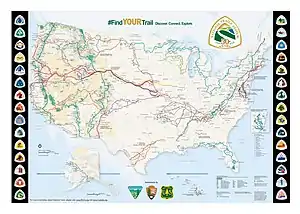
The National Trails System includes 29 long-distance hiking trails with distinctive trail markers for each
See also
- National Trails System
- National Millennium Trail project – 16 long-distance trails selected in 2000 as visionary trails that reflect defining aspects America's history and culture
- Triple Crown of Hiking - term for completing the three major trails (Pacific Crest, Appalachian, Continental Divide)
- List of long-distance footpaths
- State wildlife trails (United States)
References
- "Allegheny Trail Info". West Virginia Scenic Trails Association. 2021-01-24. Retrieved 2021-01-24The Allegheny Trail is a 287.81-mile north-south trail with its northern terminus on the Mason-Dixon Line at the Pennsylvania-West Virginia border near Bruceton Mills.
- "American Discovery Trail". American Discovery Trail Society. 2021-01-24. Retrieved 2021-01-24Its 6,800+ miles of continuous, multi-use trail stretches from Cape Henlopen State Park, Delaware, to Pt. Reyes National Seashore, California.
- "The Trail". American Discovery Trail Society. 2021-01-24. Retrieved 2021-01-24The northern route is 4,834 miles and the southern 5,057 miles.
- "Passages - Explore the Arizona Trail". aztrail.org. 2020-08-22. Retrieved 2020-08-22The 825.2 total miles is the sum of the individual passage lengths from the Arizona Trail Association web site.
- "Bay Area Ridge Trail Home". Bay Area Ridge Trail Council. Retrieved 2021-01-24The Ridge Trail circles the Bay with 390 miles (and growing) of adventures.
- "About the Bay Circuit Trail & Greenway". Bay Circuit Alliance. Retrieved 2021-01-24More than 230 miles of multi-use, passive recreational trail have now been dedicated, thanks to the contributions of hundreds of volunteers in 37 cooperating towns.
- "Vital Trail Information". Benton MacKaye Trail Association. Retrieved 2021-01-24"Current official length is 287.6."
- "Discover the Trail". Benton MacKaye Trail Association. Retrieved 2021-01-24.
... climbing to the top of Mount Sterling [...] and then descending to Big Creek — the trail’s northern terminus.
- "Bigfoot Trail Interactive Map". Bigfoot Trail Association. Retrieved 2021-01-24"Click on trail to reveal that the official length is 356.51 miles."
- "Tiadaghton Hiking". Pennsylvania Department of Conservation and Natural Resources. Retrieved 2021-01-24.
The Black Forest Trail is a 42-mile hiking trail built by the DCNR Bureau of Forestry.
- "Centennial Trail in the Black Hills of South Dakota" (PDF). gfp.sd.gov. 2010-04-28. Retrieved 2021-01-24The 111 miles is on page two of the referenced brochure.
- "Coast to Crest Trail Status". San Dieguito River Park – Preserving and interpreting the natural and cultural resources of the San Dieguito River Valley. San Dieguito River Park. Retrieved 2021-01-24.
- "Fast Facts". Parks & Trails New York. Parks & Trails New York. Retrieved 23 August 2020.
mostly flat, multi-use trail and on-road segments
- "Gandy Dancer State Trail Map". burnettcounty.com. 2020-08-22. Retrieved 2021-01-24The 98.1 total miles is the sum of the individual passage lengths from the referenced trail map.
- "Great Miami River Trail Summary". Miami Valley Trails. Retrieved 2021-01-24"57 miles, plus 19 miles total for Middletown and Hamilton segments."
- "Great Western Loop". Andrew Skurka. Retrieved 2011-07-13.
- "High Country Pathway". State of Michigan Department of Natural Resources. Retrieved 2021-01-24"The High Country Pathway is a 70 mile Loop trail system that runs from Pigeon River Country through Montmorency, Otsego, Atlanta, Cheboygan and Presque Isle counties."
- "Highlands Trail Guide". New York-New Jersey Trail Conference. Retrieved 2021-01-24"The 125.57 total miles is the sum of the individual section lengths from the Highlands Trail Guide trail map on the web site."
- "DNR: Knobstone Trail: About". www.in.gov.
- Pitchford, Joseph (December 31, 2012). "Blazing the Northeast Texas Trail". Retrieved 2013-11-08.
- "Trail Conditions". Retrieved 2013-11-08.
- "Discover the Northeast Texas Trail – 130 mile Rails to Trails conversion ~ Dallas NW". Retrieved 2013-11-08.
- "Section Descriptions and Mileages". Northville-Placid Trail Chapter of the ADK. 2015-10-03. Retrieved 2016-04-01.
- "Welcome to". Wabash Cannonball Trail. 1994-03-24. Retrieved 2015-06-09.
External links
This article is issued from Wikipedia. The text is licensed under Creative Commons - Attribution - Sharealike. Additional terms may apply for the media files.