Neath
Neath (/niːθ/; Welsh: Castell-nedd) is a town and community situated in the principal area of Neath Port Talbot, Wales with a population of 19,258 in 2011.[2] The wider urban area, which includes neighbouring settlements, had a population of 50,658 in 2011.[2] Historically in Glamorgan, the town is located on the River Neath, 7 miles (11 km) east northeast of Swansea.[3]
Neath
| |
|---|---|
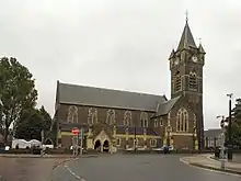
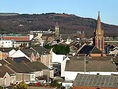 View of Neath | |
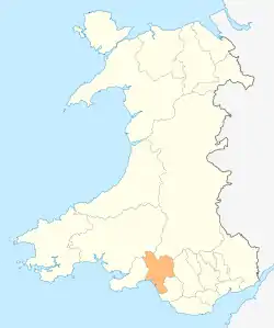
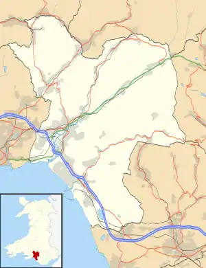 Neath Location within Neath Port Talbot | |
| Population | 19,258 |
| OS grid reference | SS745975 |
| Community |
|
| Principal area | |
| Ceremonial county | |
| Country | Wales |
| Sovereign state | United Kingdom |
| Post town | NEATH |
| Postcode district | SA10-11 |
| Dialling code | 01639 |
| Police | South Wales |
| Fire | Mid and West Wales |
| Ambulance | Welsh |
| UK Parliament | |
| Senedd Cymru – Welsh Parliament | |
Etymology
The town's English name ultimately derives from "Nedd" the original Welsh name for the River Neath and is known to be Celtic or Pre-Celtic. A meaning of shining or brilliant has been suggested, as has a link to the older Indo-European root *-nedi (simply meaning river).[4][5]
As such, the town may share its etymology with the town of Stratton, Cornwall and the River Nidd in Northern England.[6][7]
History
Roman fort
The town is located at a ford of the River Neath and its strategic situation is evident by a number of Celtic hill forts, surrounding the town. The Romans also recognised the area's strategic importance and built an Auxiliary Fort on the river's Western bank around AD 74.
Much of the site is on the grounds of Dwr-y-Felin Comprehensive School but archaeological digs have also found gate-towers that extended out beyond the fort's walls (a feature unique in Roman Britain) and a large Roman marching camp which would have accommodated thousands of troops.[8][9] These finds indicate some of the unusual measures taken by the Romans during the resistance of the native Silures and the fort at Neath was abandoned in around 125AD for fifteen years and again in around 170AD for a century before the final Roman withdrawal around 320AD.[10]
The Antonine Itinerary (c. 2nd century) names Nido (or Nidum) as one of nine places in Roman Wales.[11]
Medieval period
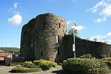
St Illtyd visited the Neath area and established a settlement in what is now known as Llantwit on the northern edge of the town. The church of St Illtyd[12] was built at this settlement and was enlarged in Norman times. The Norman and pre-Norman church structure remains intact and active to day within the Church in Wales.[13] The Welsh language name for Neath is Castell-nedd, referring to the Norman Neath Castle,[14] which was visited by English kings Henry II, John and Edward I.
Industrial and modern Neath
Neath was a market town that expanded with the arrival of the Industrial Revolution in the 18th century with new manufacturing industries of iron, steel and tinplate. The Mackworth family, who owned the Gnoll Estate[15] were prominent in the town's industrial development. Coal was mined extensively in the surrounding valleys and the construction of canals and railways made Neath a major transportation centre and the Evans & Bevan families were major players in the local coal mining community as well as owning the Vale of Neath Brewery.[16] Silica was mined in the Craig-y-Dinas area of Pontneddfechan, after Quaker entrepreneur William Weston Young invented the blast furnace silica firebrick, later moving brick production from the works at Pontwalby to the Green in Neath. The town continued as a market trading centre with a municipal cattle market run by W.B.Trick. Industrial development continued throughout the 20th century with the construction by BP of a new petroleum refinery at Llandarcy.
Admiral Lord Nelson stayed at the Castle Hotel en route to Milford Haven when the fleet was at anchor there. Lt. Lewis Roatley,[17] the son of the landlord of the Castle Hotel, served as a Royal Marines officer with Nelson aboard HMS Victory in the Battle of Trafalgar.
The River Neath is a navigable estuary and Neath was a river port until recent times. The heavy industries are no more with the town being a commercial and tourism centre. Attractions for visitors are the ruins of the Cistercian Neath Abbey, the Gnoll Park and Neath Indoor Market.[18]
Neath hosted the National Eisteddfod of Wales in 1918, 1934 and 1994.[19]
Notable people
- See Category:Neath
- Roger Blake (1957– ), actor, entertainer and impressionist;
- Mark Bowen (1963–, b. Briton Ferry), Manager of Reading FC, formerly a player with Spurs and Norwich City;
- Richard Burton (1925–1984, b. Pontrhydyfen), actor;
- Hugh Dalton (1887–1962, b. Gnoll), Labour politician, Chancellor of the Exchequer, 1945–1947;
- Ben Davies (1993– ), Tottenham Hotspur, and Wales footballer;
- Craig Mitchell (1986- ), Welsh international rugby union forward;
- David Davies, (1877–1944), Welsh international rugby union forward;
- Ivor Emmanuel (1927–2007), singer and actor;
- Hugh Evan-Thomas, vice-admiral;
- Craig Evans (born 1971), cricketer;
- Rebecca Evans (1963–, b. Pontrhydyfen), soprano;
- Sir Samuel Thomas Evans (1859–1918, b. Skewen), politician and judge;
- George Grant Francis (1814–1822, b. Swansea) historian who wrote Original Charters and Materials for a History of Neath (1845);
- Julie Gardner (1969– ), television producer previously responsible for Doctor Who and its spin-off Torchwood, now executive producer of scripted projects at BBC Worldwide;
- Richard Grant (born 1984), cricketer;
- Cecil Griffiths (1900–1945), winner of an Olympic gold medal in the 4x400m relay at the 1920 Antwerp Olympics;
- Thomas Haffield (1988– ), Great Britain Olympic swimmer;
- Carl Harris (1956– ), the former Leeds United and Wales international;
- Richard Hibbard (1983– ), Rugby player for the Dragons of the Pro14;
- T. G. H. James (1923–2009), Egyptologist and former Keeper of Egyptian Antiquities at the British Museum;
- Sir William Jenkins (1871–1944), former Neath MP;
- Katherine Jenkins (1980– ), popular classical mezzo-soprano;
- Margaret Townsend Jenkins (1843–1923), Canadian clubwoman
- Della Jones (1946, b. Tonna), mezzo-soprano;
- Kristian Lavercombe (1976–), actor and singer
- Geraint F. Lewis (1969– ), leading astrophysicist;
- Andy Legg (1966– ), former professional footballer and Wales international;
- Tony Lewis (1938–, b. Swansea), first Welshman to Captain an England cricket tour abroad, (India, Pakistan, 1972–73). Led Glamorgan to 2nd County Championship, 1969. Writer and broadcaster.
- Andrew Matthews-Owen, pianist;
- Ray Milland (1907–1986), Oscar-winning Hollywood actor;
- David Watts Morgan (1867–1933), miners' leader and politician;
- Sir William Nott (1782–1845), British General in India;
- Harry Parr-Davies (1914–1955), composer;
- Jessie Penn-Lewis (1861–1927), missioner and revivalist;
- Gary Pickford-Hopkins (1948–2013) singer, composer and guitarist;
- Sir Arthur Pugh (1870–1955, b. Ross, Hertfordshire), trade unionist, moved to his father's birthplace, Neath, 1894;[20]
- Henry Habberley Price (1899–1984), philosopher;
- Walter Enoch Rees (1863–1949), rugby administrator;
- Paul Rhys (1963– ), actor;
- Will Roberts (1907–2000, b. Ruabon, Denbighshire), artist, moved to Neath 1918;
- Peter Shreeves (1940– ), former Spurs and Sheffield Wednesday manager;
- Samuel Charles Silkin, Baron Silkin of Dulwich (1918–1988), barrister and politician, Attorney-General, 1974–1979;
- Jonathan Spratt (1986– ), Welsh rugby player
- William Squire (1917–1989), actor;
- David Thaxton (1982– ), West End performer
- Brian Thomas (1940–2012), Wales rugby union lock who also played and managed Neath RFC;
- Bonnie Tyler (1951–, b. Skewen), pop star;
- Andrew Vicari (1938–2016), artist;
- Ron Waldron (1933– ) Welsh rugby coach;
- Alfred Russel Wallace (1823, b. Monmouthshire), evolutionary theorist, lived in Neath during 1841/2 and attended lectures given by the area's scientific societies;[21]
- Cyril Walters (1905–1992), Glamorgan cricketer and Captain of the England cricket team;
- Anna Letitia Waring (1823–1910), poet and hymn writer;
- Elijah Waring (1788–1857), writer; and
- Jane Williams [called Llinos] (1795–1873), singer and compiler of traditional Welsh music.
- Andrew Rhodes (1977– ), Former Senior Civil Servant.
- Zuri (2003-) all round super star
Sport

The Welsh Rugby Union was formed at a meeting held at the Castle Hotel in 1881.[22] Neath Rugby Football Club, the famous and successful "Welsh All Blacks", play at The Gnoll. They have won 4 consecutive titles in the semi-professional Principality Premiership and 3 Swalec Cup titles (previously known as Schweppes and Konica Minolta Cups).
Motorcycle speedway was staged at the Abbey Stadium in Neath in 1962. The Welsh Dragons, led by New Zealander Trevor Redmond, raced with some success in the Provincial League but, because of local problems, a number of the "home" fixtures were raced at St Austell. The Dragons introduced the Australian rider Charlie Monk to British speedway. After a season at Long Eaton Archers, Monk went on to have considerable success at Glasgow. The team also featured South African Howdy Cornell. In the early 1960s there was also stock car racing held at Neath Abbey, opposite the monastery
Neath Athletic A.F.C. was the town's largest football team, playing at Neath RFC's ground, The Gnoll, and played in the top flight of Welsh football, the Welsh Premier League, until the club was wound up in 2012. In the 2006–07 season, Neath Athletic A.F.C. were promoted from the Welsh Football League First Division to the Welsh Premier League. Neath Athletic A.F.C. had an average of 300 supporters attending a domestic, Welsh Premier League game, which was typical of the Welsh Premier League.
Administration
The previous borough council was absorbed into the larger unitary authority of Neath Port Talbot on 1 April 1996. The town encompasses the electoral wards of Neath East, Neath North, Neath South and Cimla.
Neath and the surrounding area is represented at Westminster by Christina Rees MP (Labour) and in the Senedd by Jeremy Miles (Labour) and by four MSs within the South Wales West electoral region.
Climate
As with the rest of the British Isles and Wales, Neath experiences a maritime climate with cool summers and mild winters, often high winds, and low sunshine levels.
| Climate data for Neath 62m asl, 1961–1990 | |||||||||||||
|---|---|---|---|---|---|---|---|---|---|---|---|---|---|
| Month | Jan | Feb | Mar | Apr | May | Jun | Jul | Aug | Sep | Oct | Nov | Dec | Year |
| Average high °C (°F) | 7.6 (45.7) |
7.5 (45.5) |
9.5 (49.1) |
12.2 (54.0) |
15.4 (59.7) |
17 (63) |
19 (66) |
18 (64) |
16 (61) |
13 (55) |
9 (48) |
8 (46) |
13.4 (56.1) |
| Average low °C (°F) | 2.7 (36.9) |
2.4 (36.3) |
3.5 (38.3) |
5.1 (41.2) |
8.1 (46.6) |
10.9 (51.6) |
12.7 (54.9) |
12.6 (54.7) |
10.9 (51.6) |
8.7 (47.7) |
5.1 (41.2) |
3.6 (38.5) |
7.2 (45.0) |
| Average precipitation mm (inches) | 137 (5.4) |
90 (3.5) |
100 (3.9) |
70 (2.8) |
79 (3.1) |
79 (3.1) |
78 (3.1) |
107 (4.2) |
114 (4.5) |
130 (5.1) |
140 (5.5) |
143 (5.6) |
1,267 (49.9) |
| Mean monthly sunshine hours | 49.6 | 67.8 | 108.5 | 159.0 | 186.0 | 183.0 | 186.0 | 173.6 | 132.0 | 93.0 | 69.0 | 46.5 | 1,460 |
| Source: Met Office[23] | |||||||||||||
Education
Dwr-y-Felin Comprehensive School is situated on the outskirts of the town, opposite a campus of NPTC Group (which was previously Neath Port Talbot College. The Cefn Saeson Comprehensive School is in the village of Cimla near the Crynallt Primary School. Two other comprehensive schools serve the town: Llangatwg Comprehensive School in Cadoxton and Ysgol Bae Baglan in Baglan, Neath Port Talbot.. Primary schools include St Joseph's R C Primary School in Hillside Neath, Crynallt Primary School in Cimla, Alderman Davies Church in Wales Primary School in Neath, Gnoll Primary School in Neath, Melin Infant and Junior schools, Ysgol Gynradd Castell Nedd, Mynachlog Nedd Junior School in Skewen, Tonnau Primary School in Tonna, Tonmawr Primary School in Tonmawr, Catwg Primary School in Cadoxton, Cilfrew Primary School in Cilfrew, Wauncierch primary school in Wauncierch and Ynysmaerdy Primary School in Briton Ferry
Transport
Neath railway station is on the South Wales Main Line. Great Western Railway and Transport for Wales serve the station with services westbound to Swansea, Carmarthen and the West Wales Line and eastbound to Port Talbot Parkway, Bridgend, Cardiff Central and London Paddington. Trains also run via Hereford and Shrewsbury to Crewe and Manchester Piccadilly.
Neath bus station is at Victoria Gardens, a five-minute walk from the railway station. National Express services call at the railway station. From Victoria Gardens, First Cymru provides direct inter-urban services to nearby Swansea and Port Talbot in addition to South Wales Transport who provide many similar local services.
The A465 skirts the town to the north east and provides a link to the M4.
Plans
There are plans to regenerate around 1,000 acres (4.0 km2) of land in and around Neath town centre in the near future. The site once occupied by the previous civic centre will be redeveloped as a new shopping centre. The area around the Milland Road Industrial Estate will be redeveloped along with the area around the Neath Canal. On 27 November 2008, proposals for an "iconic" golden rugby ball-shaped museum, a library, heritage centre and other new facilities were announced for consultation. The developer, Simons Estates, says that it plans to start construction when the economic climate improves.[24]
In March 2008, the county's new radio station, Afan FM, announced plans to turn on a new transmitter dedicated to the Neath area in the summer. This will transmit on 97.4 FM, and will give residents of Neath their first taste of the borough's new local radio station, which already transmits to the neighbouring area of Port Talbot on 107.9 FM. The new transmitter for the Neath area was commissioned by Government regulator Ofcom on Thursday 23 October 2008.
References
- http://www.neathtowncouncil.gov.uk/
- "Neath". Neighbourhood Statistics. Office for National Statistics. Retrieved 8 February 2013.
- John Paxton, ed. (1999). The Penguin Encyclopedia of Places (Third ed.). London: Penguin. p. 628.
- Wyn Owen, Hywel; Richard Morgan (2008). Dictionary of the Place-names of Wales. Llandysul: Gomer Press. p. 342.
- John Davies; Nigel Jenkins; Menna Baines; Peredur I. Lynch, eds. (2008). The Welsh Academy Encyclopedia of Wales. Cardiff: University of Wales Press. p. 603.
- "Etymology". Retrieved 27 August 2011.
- Weatherhill, Craig (2009) A Concise Dictionary of Cornish Place-names. Westport, Co. Mayo: Evertype; p. 65
- Nidum Roman dig in playing fields BBC Wales, 21 February 2011
- "BLAEN CWM BACH CAMP", Coflein.gov.uk
- coflein NPRN: 301350
- "The Antonine Itinerary – Iter Britanniarum – The British Section". Archived from the original on 27 July 2009. Retrieved 27 October 2009.
- Parish of Neath: St. Illtyd Archived 8 May 2006 at the Wayback Machine
- Church in Wales
- Neath Castle
- Britton Manor
- Neath Brewery
- "HMS VICTORY. MAN~OF~WAR 1805 MUSTER LISTS". Archived from the original on 15 June 2006. Retrieved 11 June 2006.
- Gnoll Park
- "Eisteddfod Locations". The National Eisteddfod of Wales. Archived from the original on 23 May 2011. Retrieved 3 October 2010.
- Oxford DNB article: Pugh, Sir Arthur
- Oxford DNB article: Wallace, Alfred Russel
- "The History of The Castle Hotel". Neath SA11 1RB, Wales: The Castle Hotel. Archived from the original on 14 May 2008. Retrieved 5 February 2009.
The Castle Hotel was the meeting place for the founders of the Welsh Rugby Union. The inaugural meeting of the Welsh Rugby Union took place in the Nelson Room at the Castle Hotel on 12th March, 1881. There is a plaque outside the hotel commemorating the 100th anniversary of the Welsh Rugby Union, and at that time the Nelson Room name was changed to the Centenary Room. Still displayed in the room are the plaques of the original eleven members of the Welsh Rugby Union.
CS1 maint: location (link) - "Neath 1961–90 averages". Met Office. Archived from the original on 10 February 2001. Retrieved 25 September 2011.
- BBC NEWS |'Iconic' museum planned for town
External links
| Wikivoyage has a travel guide for Neath. |
| Wikimedia Commons has media related to Neath. |
| Wikisource has the text of the 1905 New International Encyclopedia article "Neath". |
- History of Neath
- Neath Port Talbot Council Adult Learning Portal
- www.geograph.co.uk : photos of Neath and surrounding area
- Wiki style Map of the neath area
- Photo Archive Gallery of old Neath & District
| Communities |
|  |
|---|---|---|
| Towns and villages |
| |
| Castles | ||
| Rivers | ||
| Natural Sites & Parks | ||
| Topics | ||
| Authority control |
|---|