SA postcode area
The SA postcode area, also known as the Swansea postcode area,[2] is a group of 51 postcode districts for post towns Aberaeron, Ammanford, Boncath, Burry Port, Cardigan, Carmarthen, Clynderwen, Crymych, Ferryside, Fishguard, Glogue, Goodwick, Haverfordwest, Kidwelly, Kilgetty, Lampeter, Llanarth, Llandeilo, Llandovery, Llandysul, Llanelli, Llanfyrnach, Llangadog, Llangrannog, Llansaint, Llanwrda, Llanybydder, Milford Haven, Narberth, Neath, New Quay, Newcastle Emlyn, Newport, Pembroke, Pembroke Dock, Pencader, Pontardawe, Port Talbot, Saundersfoot, Swansea, Tenby and Whitland forming south-west Wales.
Swansea | |
|---|---|
 SA | |
| Coordinates: 51.771°N 4.223°W | |
| Country | United Kingdom |
| Postcode area | SA |
| Postcode area name | Swansea |
| Post towns | 40 |
| Postcode districts | 53 |
| Postcode sectors | 152 |
| Postcodes (live) | 23,159 |
| Postcodes (total) | 29,241 |
| Statistics as at May 2020[1] | |
Coverage
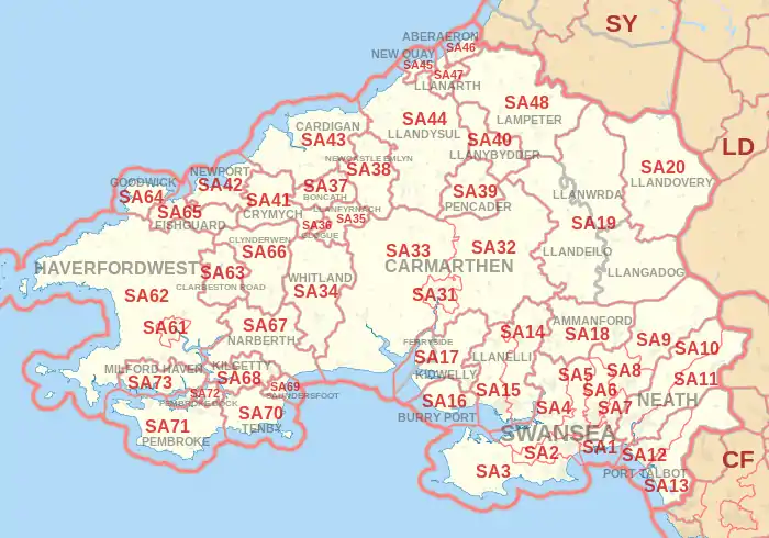
The approximate coverage of the postcode districts:
|- ! SA1 | SWANSEA | Bonymaen, Copper Quarter, Crymlyn Burrows, Danygraig, Greenhill, Hafod, Jersey Marine, Landore, Maritime Quarter, Mayhill, Mount Pleasant, Pentrechwyth, Port Tennant, St. Thomas, City Centre, Townhill, Waun Wen, Winch Wen, Winch Wen Industrial Estate | Swansea |- ! SA2 | SWANSEA | Brynmill, Cockett, Derwen Fawr, Dunvant, Fairwood, Glanmor, Hendrefoilan, Hendrefoilan Student Village, Ilston, Killay, Sketty, Sketty Park, Singleton Park (University Campus), Tycoch, Uplands, Upper Killay | Swansea |- ! SA3 | SWANSEA | Bishopston, Blackpill, Caswell, Clyne, Langland, Mumbles, Oystermouth, Southgate, South Gower, West Cross, | Swansea |- ! SA4 | SWANSEA | Blue Anchor, Gorseinon, Gowerton, Hendy (Carmarthenshire), Loughor, North Gower, Penllergaer, Penclawdd, Pontarddulais, Three Crosses | Swansea, Carmarthenshire |- ! SA5 | SWANSEA |Blaenymaes, Cwmdu, Cwmdu Industrial Estate, Felindre, Fforestfach, Gendros, Llangyfelach, Llewitha, Manselton, Penlan, Portmead, Tirdeunaw, Waunarlwydd | Swansea |- ! SA6 | SWANSEA | Clase, Cwmrhydyceirw, Clydach, Morriston, Plasmarl, Plasmarl Industrial Estate, Swansea Enterprise Park, Ynystawe, Ynysforgan | Swansea |- ! SA7 | SWANSEA | Birchgrove, Glais, Llansamlet, Swansea Enterprise Park, Talycoppa, Trallwn | Swansea |- ! SA8 | SWANSEA | Alltwen, Cwmtawe, Pontardawe, Rhos, Rhyd-y-fro, Trebanos, Ynysmeudwy | Neath Port Talbot |- ! SA9 | SWANSEA | Abercraf, Cefnbrynbrain, Cwmllynfell, Cwmtwrch, Lower Cwmtwrch, Rhiwfawr, Upper Cwmtwrch, Ystalyfera, Ystradgynlais, Ystradowen | Neath Port Talbot, Powys, Carmarthenshire |- ! SA10 | NEATH | Aberdulais, Bryncoch, Cadoxton, Caewern, Coed Darcy, Crynant, Jersey Marine, Llandarcy, Neath Abbey, Onllwyn, Seven Sisters, Skewen | Neath Port Talbot |- ! SA11 | NEATH | Blaengwrach, Briton Ferry, Cimla, Glynneath, Neath town centre, Resolven, Tonmawr, Tonna | Neath Port Talbot |- ! SA12 | PORT TALBOT | Aberafan, Aberavon, Baglan, Cwmafan, Port Talbot town centre, Sandfields, | Neath Port Talbot |- ! SA13 | PORT TALBOT | Bryn, Cymmer, Margam, Taibach | Neath Port Talbot |- ! SA14 | LLANELLI | Llanelli (east), Bynea, Dafen | Carmarthenshire |- ! SA15 | LLANELLI | Llanelli (west and town centre), Felinfoel, Pontyates | Carmarthenshire |- ! SA16 | BURRY PORT | Burry Port, Pembrey | Carmarthenshire |- ! SA17 | FERRYSIDE | Ferryside, Trimsaran | Carmarthenshire |- ! SA17 | KIDWELLY | Kidwelly, Llansaint, Mynyddygarreg, Carway | Carmarthenshire |- ! SA18 | AMMANFORD | Ammanford, Betws, Garnswllt, Gwaun-Cae-Gurwen, Lower Brynamman, Upper Brynamman | Carmarthenshire, Neath Port Talbot, Swansea |- ! rowspan=3 |SA19 | LLANDEILO | Llandeilo | Carmarthenshire |- | LLANGADOG | Llangadog | Carmarthenshire |- | LLANWRDA | Llanwrda | Carmarthenshire |- ! SA20 | LLANDOVERY | Llandovery | Carmarthenshire |- ! SA31 | CARMARTHEN | Carmarthen town centre, Cwmffrwd | Carmarthenshire |- ! SA32 | CARMARTHEN | Nantgaredig, Dryslwyn, Porthyrhyd | Carmarthenshire |- ! SA33 | CARMARTHEN | Bancyfelin, Pendine, Blaenycoed, St Clears | Carmarthenshire |- ! SA34 | WHITLAND | Whitland | Carmarthenshire |- ! SA35 | LLANFYRNACH | Llanfyrnach | Pembrokeshire |- ! SA36 | GLOGUE | Glogue, Hermon | Pembrokeshire |- ! SA37 | BONCATH | Boncath, Blaenffos | Pembrokeshire |- ! SA38 | NEWCASTLE EMLYN | Newcastle Emlyn | Carmarthenshire, Ceredigion |- ! SA39 | PENCADER | Pencader, Llanfihangel-ar-Arth, Llanllwni | Carmarthenshire, Ceredigion |- ! SA40 | LLANYBYDDER | Llanybydder, Llanwenog, Gorsgoch | Carmarthenshire, Ceredigion |- ! SA41 | CRYMYCH | Crymych, Eglwyswrw | Pembrokeshire |- ! SA42 | NEWPORT | Newport, Dinas Cross | Pembrokeshire |- ! SA43 | CARDIGAN | Cardigan, Cilgerran, St Dogmaels | Ceredigion, Pembrokeshire |- ! SA44 | LLANDYSUL | Llandysul, Dre-fach Felindre, Pentrecwrt | Ceredigion, Carmarthenshire |- ! SA45 | NEW QUAY | New Quay | Ceredigion |- ! SA46 | ABERAERON | Aberaeron | Ceredigion |- ! SA47 | LLANARTH | Llanarth | Ceredigion |- ! SA48 | LAMPETER | Lampeter | Ceredigion |- ! style="background:#FFFFFF;"|SA48 | style="background:#FFFFFF;"|ABERAERON | style="background:#FFFFFF;"| | style="background:#FFFFFF;"|non-geographic[3] |- ! SA61 | HAVERFORDWEST | Haverfordwest town centre, Merlin's Bridge | Pembrokeshire |- ! SA62 | HAVERFORDWEST | St Davids, Johnston | Pembrokeshire |- ! SA63 | CLARBESTON ROAD | Clarbeston | Pembrokeshire |- ! SA64 | GOODWICK | Goodwick | Pembrokeshire |- ! SA65 | FISHGUARD | Fishguard, Cwm Gwaun | Pembrokeshire |- ! SA66 | CLYNDERWEN | Clynderwen | Pembrokeshire |- ! SA67 | NARBERTH | Narberth | Pembrokeshire |- ! SA68 | KILGETTY | Kilgetty | Pembrokeshire |- ! SA69 | SAUNDERSFOOT | Saundersfoot | Pembrokeshire |- ! SA70 | TENBY | Tenby, Penally | Pembrokeshire |- ! SA71 | PEMBROKE | Pembroke | Pembrokeshire |- ! style="background:#FFFFFF;"|SA72 | style="background:#FFFFFF;"|PEMBROKE | style="background:#FFFFFF;"| | style="background:#FFFFFF;"|non-geographic[3][4] |- ! SA72 | PEMBROKE DOCK | Pembroke Dock | Pembrokeshire |- ! SA73 | MILFORD HAVEN | Milford Haven | Pembrokeshire |- ! style="background:#FFFFFF;"|SA80 | style="background:#FFFFFF;"|SWANSEA | style="background:#FFFFFF;"|Department for Work and Pensions | style="background:#FFFFFF;"|non-geographic[3] |- ! style="background:#FFFFFF;"|SA99 | style="background:#FFFFFF;"|SWANSEA | style="background:#FFFFFF;"|Driver and Vehicle Licensing Agency | style="background:#FFFFFF;"|non-geographic[3] |}
Map
References
- "ONS Postcode Directory Version Notes" (ZIP). National Statistics Postcode Products. Office for National Statistics. May 2020. Table 2. Retrieved 19 June 2020. Coordinates from mean of unit postcode points, "Code-Point Open". OS OpenData. Ordnance Survey. February 2012. Retrieved 21 April 2012.
- Royal Mail, Address Management Guide, (2004)
- "Non Geographic Codes" (PDF). Royal Mail Address Management Unit. July 2012. Archived from the original (PDF) on 16 September 2012. Retrieved 20 December 2012.
- "New sectors and localities to 14 December 2012" (PDF). Royal Mail Address Management Unit. 20 December 2012. Archived from the original (PDF) on 2 February 2015. Retrieved 20 December 2012.