North Haven, Maine
North Haven is a town and island in Knox County, Maine, United States, in Penobscot Bay. The town is both a year-round island community and a prominent summer colony. The population was 355 at the 2010 census. North Haven is accessed by three-times daily ferry service from Rockland, or by air taxi from Knox County Regional Airport.
North Haven, Maine | |
|---|---|
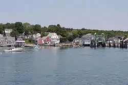 Harborfront and ferry terminal, 2005 | |
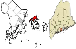 Location in Knox County and the state of Maine. | |
| Coordinates: 44°9′15″N 68°52′41″W | |
| Country | United States |
| State | Maine |
| County | Knox |
| Incorporated | 1846 |
| Area | |
| • Total | 82.49 sq mi (213.65 km2) |
| • Land | 11.62 sq mi (30.10 km2) |
| • Water | 70.87 sq mi (183.55 km2) |
| Elevation | 0 ft (0 m) |
| Population | |
| • Total | 355 |
| • Estimate (2012[3]) | 352 |
| • Density | 30.6/sq mi (11.8/km2) |
| Time zone | UTC-5 (Eastern (EST)) |
| • Summer (DST) | UTC-4 (EDT) |
| ZIP code | 04853 |
| Area code(s) | 207 |
| FIPS code | 23-51620 |
| GNIS feature ID | 0582633 |
History
As early as 3300 BC, the island was visited by the Red Paint People. Later it became part of the territory of the Penobscot Abenaki Indians, who hunted and fished in canoes along the coast. Captain Martin Pring, the explorer from Bristol, England, "discovered" North Haven and Vinalhaven in 1603. He called them the Fox Islands, a name which survives on the Fox Islands Thoroughfare, a strait separating the towns which provides passage for boats crossing Penobscot Bay.[4]
Settled in the 1760s, North Haven was originally the North Island of Vinalhaven, from which it was set off and incorporated on June 30, 1846 as Fox Isle. It was changed to North Haven on July 13, 1847. An act was passed by the state legislature in 1850 which gave the majority of island inhabitants "the right to have such roads as they deemed fit." The majority thereupon decided to have no roads at all, or else roads obstructed with gates or bars at the discretion of landowners. Not surprisingly, the minority of inhabitants petitioned to amend the act.[5]
Fishing and farming became chief occupations. The surface of the town is even, and farmers produced hay as a staple crop. Boatbuilding became an important industry, and even now the community has two boatyards. But many inhabitants were fishermen who caught lobsters, scallops and oysters.[5]
Summer colony
In the 1880s, the island was discovered by "rusticators," seasonal residents first from Boston, then followed a decade or two later by others from New York and Philadelphia. North Haven is best known today for its sizable summer colony of prominent Northeasterners, particularly Boston Brahmins, drawn to the island for over a century to savor its simple way of life.[4] Among the more notable summer residents was the impressionist painter Frank Weston Benson, who rented the Wooster Farm as a summer home and painted several notable canvases set on the island.[6]
The southern side of the Fox Islands Thoroughfare is often informally considered part of North Haven, since Vinalhaven's north shore is nearly a dozen miles from that community's town center. In contrast to Vinalhaven, North Haven's economy relies less on the lobster industry and more on sustaining its summer resort community. Energy for the community is partially provided by the wind project in Vinalhaven through the Fox Island Electric Cooperative.[7] Although the island is a popular destination, it actually provides few tourist amenities—two inns, a grocery store, two seasonal restaurants, a pizza shop, and two gift shops—and is instead geared toward those with vacation homes on the island.
A small population of Mouflon sheep (native to Europe and western Asia) escaped from an animal enclosure owned by Thomas Watson, Jr. on the island in the 1990s and survived for many years though it is thought the last one died around 2016.[8]
North Haven Dinghy
In 1885, William Weld challenged the yachtsmen of North Haven to a race. He used the tender from his yacht Gitana and unsuccessfully raced against a variety of sprit-sailed boats. That winter he went home and had a better dinghy designed and built in Salem, Massachusetts. The next year he beat all contenders. The boat was hauled out at North Haven, and two copies were made by Henry Calderwood. The subsequent race was between Mrs. Cobb, Miss Spencer and Miss Hayward. The first boats had spritsails, but this soon gave way to gaff rigs. In 1888, James Osman Brown built four more dinghies. This was at the beginning of J. O. Brown & Sons boatyard. The racing fleet grew over the years. They are still raced out of North Haven's sailing club, the North Haven Casino, making them the oldest continuously raced class in the United States. A group of loyal North Haven Dinghy racers [9]
Geography
According to the United States Census Bureau, the town has a total area of 82.49 square miles (213.65 km2), of which, 11.62 square miles (30.10 km2) of it is land and 70.87 square miles (183.55 km2) is water.[1] At its widest points, the island of North Haven is roughly 7.9 miles (12.7 km) long and 2.9 miles (4.7 km) wide. It is situated in Penobscot Bay and the Gulf of Maine, part of the Atlantic Ocean.
Demographics
| Historical population | |||
|---|---|---|---|
| Census | Pop. | %± | |
| 1850 | 806 | — | |
| 1860 | 951 | 18.0% | |
| 1870 | 806 | −15.2% | |
| 1880 | 755 | −6.3% | |
| 1890 | 552 | −26.9% | |
| 1900 | 551 | −0.2% | |
| 1910 | 535 | −2.9% | |
| 1920 | 510 | −4.7% | |
| 1930 | 476 | −6.7% | |
| 1940 | 460 | −3.4% | |
| 1950 | 410 | −10.9% | |
| 1960 | 384 | −6.3% | |
| 1970 | 399 | 3.9% | |
| 1980 | 373 | −6.5% | |
| 1990 | 332 | −11.0% | |
| 2000 | 381 | 14.8% | |
| 2010 | 355 | −6.8% | |
| 2014 (est.) | 350 | [10] | −1.4% |
| U.S. Decennial Census[11] | |||
2000 census
As of the census[12] of 2000, there were 381 people, 162 households, and 109 families residing in the town. The population density was 32.7 people per square mile (12.6/km2). There were 488 housing units at an average density of 41.9 per square mile (16.2/km2). The racial makeup of the town was 95.28% White, 1.05% African American, 3.15% from other races, and 0.52% from two or more races. Hispanic or Latino of any race were 2.36% of the population.
There were 162 households, out of which 29.0% had children under the age of 18 living with them, 57.4% were married couples living together, 4.3% had a female householder with no husband present, and 32.7% were non-families. 27.8% of all households were made up of individuals, and 10.5% had someone living alone who was 65 years of age or older. The average household size was 2.35 and the average family size was 2.86.
In the town, the population was spread out, with 25.2% under the age of 18, 5.2% from 18 to 24, 30.2% from 25 to 44, 27.0% from 45 to 64, and 12.3% who were 65 years of age or older. The median age was 39 years. For every 100 females, there were 103.7 males. For every 100 females age 18 and over, there were 112.7 males.
The median income for a household in the town was $40,446, and the median income for a family was $42,361. Males had a median income of $31,071 versus $16,000 for females. The per capita income for the town was $17,112. About 4.4% of families and 7.2% of the population were below the poverty line, including 2.8% of those under age 18 and 6.3% of those age 65 or over.
2010 census
As of the census[2] of 2010, there were 355 people, 165 households, and 105 families residing in the town. The population density was 30.6 inhabitants per square mile (11.8/km2). There were 515 housing units at an average density of 44.3 per square mile (17.1/km2). The racial makeup of the town was 96.9% White, 0.3% African American, 0.3% Asian, 0.6% from other races, and 2.0% from two or more races. Hispanic or Latino of any race were 2.3% of the population.
There were 165 households, of which 23.0% had children under the age of 18 living with them, 49.1% were married couples living together, 11.5% had a female householder with no husband present, 3.0% had a male householder with no wife present, and 36.4% were non-families. 29.7% of all households were made up of individuals, and 9.6% had someone living alone who was 65 years of age or older. The average household size was 2.15 and the average family size was 2.62.
The median age in the town was 44.5 years. 20% of residents were under the age of 18; 5.6% were between the ages of 18 and 24; 25.9% were from 25 to 44; 29.1% were from 45 to 64; and 19.4% were 65 years of age or older. The gender makeup of the town was 52.4% male and 47.6% female.
Education
North Haven is unusual among Maine island communities for offering a K–12 school whereas most islands only have elementary schools and tuition their high school students to high schools on the mainland (Vinalhaven, Mount Desert Island, and Islesboro are the only other islands to offer K–12 education). North Haven Community School is one of the smallest public schools in Maine. The school’s motto is “Competence, Compassion, Challenge and Community.” Notable alumni include Hannah Pingree, who served as Maine’s Speaker of the House of Representatives for two terms.[13]
Notable people
- Angela Adams, designer
- Frank Weston Benson, artist with summer home on North Haven
- Harold Beverage, electrical engineer and inventor
- Elizabeth Bishop, poet
- Jonathan Bush, banker
- Cabot family
- Henry N. Cobb, architect
- Herbert Eustis Winlock, Egyptologist
- Pierre S. du Pont, IV, politician
- J. Christopher Flowers, banker[14]
- Ned Lamont, politician[15]
- John D. Macomber, banker
- Seth G. Macy, IGN editor and personality [16]
- Burke Marshall, lawyer, professor[17]
- Susan Minot, writer[18]
- Robert Montgomery, actor[19]
- Dwight Morrow, ambassador[20]
- Chellie Pingree, US congresswoman, Maine Senate majority leader
- Hannah Pingree, former speaker of the Maine House of Representatives
- Nicholas Platt, US ambassador
- Oliver Platt, actor[21]
- Saltonstall family
- Matthew Simmons, investment banker
- John Sirica, U.S. District Court Judge, Watergate figure
- Weld family
- Wilford Woodruff, 4th president of the LDS Church, spent August 1837 until May 1838 on North Haven and in 1838 led 53 new members to Missouri but continued to Nauvoo, Illinois because of the 1838 Missouri Mormon War.[22]
References
- "US Gazetteer files 2010". United States Census Bureau. Retrieved December 16, 2012.
- "U.S. Census website". United States Census Bureau. Retrieved December 16, 2012.
- "Population Estimates". United States Census Bureau. Archived from the original on June 11, 2013. Retrieved July 6, 2013.
- "History". northhavenmaine.org. Retrieved March 4, 2015.
- Coolidge, Austin J.; John B. Mansfield (1859). A History and Description of New England. Boston, Massachusetts: A.J. Coolidge. p. 236.
coolidge mansfield history description new england 1859.
- "Calm Morning". Museum of Fine Arts Boston. Retrieved September 13, 2018.
- Borst, Alan. Community Wind: Maine island community lowering energy costs with wind-power project. Archived April 7, 2010, at the Wayback Machine Rural Cooperatives. March/April 2010.
- "Thomas J. Watson, Jr Facts". Encyclopedia of World Biography. The Gale Group, Inc. Retrieved September 24, 2015.
- "North Haven Dingy Half-Hull Model". worldvoyagers.com. Retrieved March 4, 2015.
- "Annual Estimates of the Resident Population for Incorporated Places: April 1, 2010 to July 1, 2014". Archived from the original on May 23, 2015. Retrieved June 4, 2015.
- "Census of Population and Housing". Census.gov. Retrieved June 4, 2015.
- "U.S. Census website". United States Census Bureau. Retrieved January 31, 2008.
- http://northhavenschool.weebly.com/about.html
- Chris Flowers: Checkmate for a Wall Street wizard? - Aug. 31, 2009 Retrieved April 14, 2017.
- When Political Paths Diverge but Old Loyalties Endure, New York Times, By SAM ROBERTS, NOV. 5, 2006 Retrieved April 14, 2017.
- MS. MARSHALL PLANS TO WED - NYTimes.com Retrieved April 14, 2017.
- A Family History in Rewrite - The New York Times Retrieved April 14, 2017.
- "The Golden Age of Radio" (As originally broadcast on WTIC, Hartford, CT) Retrieved April 14, 2017.
- Deacon Brown's Point, the Morrows' summer home at North Haven, Maine Retrieved April 14, 2017.
- Star Map of North Haven Island | Portland Magazine Retrieved April 14, 2017.
- "1. Images of Wilford Woodruff's Life: A Photographic Journey". byu.edu. Retrieved March 4, 2015.
External links
| Wikimedia Commons has media related to North Haven, Maine. |
- Town of North Haven, Maine
- North Haven Library
- North Haven Conservation Partners
- Island Dirt - News and Events from North Haven
- Maine Genealogy: North Haven, Knox County, Maine
- North Haven Island Maine overview
Sites of interest
- Calderwood Hall Gallery
- Goose Rocks Light
- North Haven Conservation Partners
- North Haven Historical Society & Museum
- Waterman's Community Center -- North Haven Arts & Enrichment
Municipalities and communities of Knox County, Maine, United States | ||
|---|---|---|
| City |  Knox County map | |
| Towns | ||
| Plantation | ||
| Unorganized territories | ||
| CDPs | ||
| Other villages | ||
| ||
| Authority control |
|---|