Regions of Thailand
Thailand is variably divided into different sets of regions, the most notable of which are the six-region grouping used in geographic studies, and the four-region grouping consistent with the Monthon administrative regional grouping system formerly used by the Ministry of Interior. These regions are the largest subdivisions of the country.
In contrast to the administrative divisions of the provinces of Thailand, the regions no longer have an administrative character, but are used for statistical or academic purposes.
Grouping systems
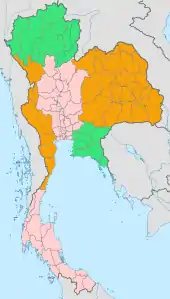
A six-region system is commonly used for geographical and scientific purposes. This system dates to 1935.[1] It was formalised in 1977 by the National Geographical Committee, which was appointed by the National Research Council. It divides the country into the following regions:
- Northern Thailand
- Northeastern Thailand (Isan)
- Western Thailand
- Central Thailand
- Eastern Thailand
- Southern Thailand
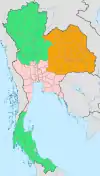
The four-region system, used in some administrative and statistical contexts, and also as a loose cultural grouping, includes the western and eastern regions within the central region, while grouping the provinces of Sukhothai, Phitsanulok, Phichit, Kamphaeng Phet, Phetchabun, Nakhon Sawan, and Uthai Thani in the northern region. This is also the regional system most commonly used on national television, when discussing regional events. It divides the country into the following regions:
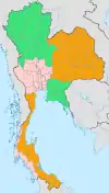
The Thai Meteorological Department divides the country into six regions for meteorological purposes.[2] It differs from the four-region system in that the east is regarded as a separate region, the south is divided into east and west coasts, and Nakhon Sawan and Uthai Thani are grouped in the central region.
Comparison
Regional economic disparities
Thailand's economic activities are concentrated in Bangkok and the central region. In 2013, the central region's gross regional product (GRP) contributed 40.9 percent to Thailand's GDP. Other regions accounted for 10.9 percent (northeastern); 8.8 percent (northern); and 8.6 percent (southern). GRP per capita varied. The average GRP per capita of the central region was 280,734 baht, while that of the northeastern region was 74,532 baht.[3]
Human Development Regions
This is a list of the 4 Thai regions and the capital city of Bangkok by Human Development Index as of 2020 with data for the year 2018.[4]
| Very High Human Development | |||
|---|---|---|---|
| Rank | Region | 2018 HDI | Comparable country (2018)[5] |
| 1 | Bangkok | 0.813 | |
| High Human Development | |||
| 2 | Central Thailand (without Bangkok) | 0.768 | |
| – | 0.765 | ||
| 3 | Southern Thailand | 0.755 | |
| 4 | Northeastern Thailand | 0.749 | |
| 5 | Northern Thailand | 0.747 | |
See also
- Subdivisions of Thailand
- List of countries by Human Development Index
References
- Mundus. Wissenschaftliche Verlagsgesellschaft. 1981. p. 65. Retrieved 17 January 2012.
- "Home; Weather". Thai Meteorlogical Department. Retrieved 4 October 2018.
- "The Twelfth National Economic and Social Development Plan, 2017–2021". Office of the National Economic and Social Development Board (NESDB). pp. 58–59. Retrieved 10 October 2017.
- "Sub-national HDI - Area Database - Global Data Lab". hdi.globaldatalab.org. Retrieved 2020-03-08.
- "Human Development Report 2019 – "Human Development Indices and Indicators"" (PDF). HDRO (Human Development Report Office) United Nations Development Programme. pp. 22–25. Retrieved 4 December 2018.
External links
| History |  | ||||
|---|---|---|---|---|---|
| Geography |
| ||||
| Politics | |||||
| Economy | |||||
| Society |
| ||||