Ontario Highway 117
King's Highway 117, commonly referred to as Highway 117, is a provincially maintained highway in the Canadian province of Ontario. The route travels across Muskoka between Highway 11 north of Bracebridge and Highway 35 at Dorset, with Baysville being the only significant community between the two. It was created in 1974 by renumbering a portion of Highway 118, and existed until 1997, when it was transferred to the District Municipality of Muskoka. Today the former highway is known as Muskoka District Road 117.
| ||||||||||
|---|---|---|---|---|---|---|---|---|---|---|
| Route information | ||||||||||
| Maintained by the Ministry of Transportation of Ontario | ||||||||||
| Length | 43.0 km[1] (26.7 mi) | |||||||||
| Existed | 1961 (in Vaughan) 1974 (in Muskoka)–1970 (in Vaughan) January 1, 1998 (in Muskoka) | |||||||||
| Major junctions | ||||||||||
| West end | ||||||||||
| East end | ||||||||||
| Highway system | ||||||||||
| ||||||||||
Route description
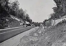
Highway 117 connected Highway 11 north of Bracebridge with Highway 35 in Dorset, and is now known as Muskoka Road 117. More than half of the route travels along the southern shoreline of Lake of Bays. While a majority of the route is surrounded by rock and forest as it winds through the Canadian Shield, it passes through the communities of Baysville, Ninth Grove, Grandview, Browns Brae and Grove Park.[2][3]
Beginning at Exit 193 along Highway 11, immediately north of Bracebridge, the former Highway 117 travels east through thick forests, with sparse residences lining the route. In Baysville, the route crosses the Muskoka River and curves northeast. It follows the southern shoreline of Lake of Bays for the remainder of its length, providing access to numerous cottages surrounding the lake. Highway 117 ended at Highway 35 just south of Dorset.[2][3]
History
Highway 117, which existed from 1974 to 1998, extended 43 kilometres (27 mi) between the communities of Bracebridge and Dorset in the Muskoka region. On January 1, 1998, the Ministry of Transportation of Ontario decommissioned the entire route.[4] Jurisdiction over the road was transferred to the District Municipality of Muskoka and renumbered as Muskoka Road 117.[2]
Major intersections
The following table lists the major junctions along Highway 117, as noted by the Ministry of Transportation of Ontario.[1] The entire route was located in the District Municipality of Muskoka.
| Location | km[1] | mi | Destinations | Notes | |
|---|---|---|---|---|---|
| Bracebridge | 0.0 | 0.0 | |||
| Lake of Bays | 16.5 | 10.3 | District Road 2 (Brunel Road) – Huntsville | ||
| 27.3 | 17.0 | Browns Brae Road | |||
| Dorset | 42.7 | 26.5 | District Road 39 (Main Street) | ||
| 43.0 | 26.7 | ||||
| 1.000 mi = 1.609 km; 1.000 km = 0.621 mi | |||||
References
- Ministry of Transportation of Ontario (April 1, 1989). Provincial Highways Distance Table. Government of Ontario. p. 84. ISSN 0825-5350.
- Mapart (2010). Ontario Back Road Atlas (Map). Peter Heiler Ltd. p. 59. § S33–T36. ISBN 978-1-55198-226-7.
- Highway 117 - Length and Route (Map). Retrieved October 31, 2020.
- Highway Transfers List - "Who Does What" (Report). Ministry of Transportation of Ontario. June 20, 2001. p. 9.

