Ontario Provincial Highway Network
The Provincial Highway Network consists of all the roads in Ontario maintained by the Ministry of Transportation of Ontario (MTO), including those designated as King's Highways, Secondary highways, or Tertiary highways. The system . Components of the system — which comprises 16,900 kilometres (10,500 mi) of roads and 2,880 bridges — range in scale from Highway 401, the busiest highway in North America, to unpaved forestry and mining access roads. The longest highway is nearly 2,000 kilometres (1,200 mi) long, while the shortest is less than a kilometre. Some roads are unsigned highways, lacking signage to indicate their maintenance by the MTO; these may be remnants of highways that are still under provincial control whose designations were decommissioned, roadway segments left over from realignment projects, or proposed highway corridors.
| Provincial Highway Network | |
|---|---|
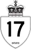 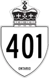  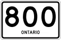 Highway markers for King's Highway 17, King's Highway 401, Secondary Highway 600, and Tertiary Highway 800 | |
| System information | |
| Maintained by MTO | |
| Length | 16,900 km[1] (10,500 mi) |
| Formed | February 26, 1920[2] |
| Highway names | |
| Types |
|
| System links | |
Predecessors to today's modern highways include the foot trails and portages used by indigenous peoples in the time before European settlement. Shortly after the creation of the Province of Upper Canada in 1791, the new government under John Graves Simcoe built overland military roads to supplement water-based transportation, including Yonge Street and Dundas Street. At the time, road construction was under the control of the township and county governments. Local township roads were financed and constructed through a statute labor system that required landowners to make improvements in lieu of taxes. Private companies constructed corduroy and later plank roads and charged tolls in the second half of the 19th century. The rising popularity of the bicycle led to the formation of Ontario Good Roads Association, which advocated for the improvement of roads and recreation as the automobile rose to prominence.
By the early 20th century, the province had taken interest in road improvement and began funding it through counties. The increasing adoption of the automobile resulted in the formation of the Department of Public Highways of Ontario (DPHO) in 1916. The passing of the Canada Highways Act in 1920 resulted in the establishment of a provincial network of highways. The DPHO assigned internal highway numbers to roads in the system, and in 1925, the numbers were signposted along the roads and marked on maps. In 1930, provincial highways were renamed King's Highways and the familiar crown route markers created. The DPHO was also renamed the Department of Highways (DHO). The 1930s saw several major depression relief projects built by manual labour, including the first inter-city divided highway in North America along the Middle Road, which would become the Queen Elizabeth Way in 1939. In 1937, the DHO merged with the Department of Northern Development, extending the highway network into the Canadian Shield. Significant traffic engineering and surveying through the war years, during which construction came to a near standstill, leading to the planning and initial construction of controlled-access highways. The 400-series highways were built beginning in the late 1940s and numbered in 1952. The vast majority of modern road infrastructure in Ontario was built throughout the 1950s, 1960s, and early 1970s. The cancellation of the controversial Spadina Expressway and the introduction of the Environmental Assessment Act in the 1970s resulted in a decline in new highway construction. In the late 1990s, nearly 5,000 kilometres (3,100 mi) of provincial highways were transferred, or "downloaded" back to lower levels of government. Few new freeways have been built in the early years of the 21st century, although several major infrastructure projects including the Herb Gray Parkway and expansion of Highway 69 have proceeded.
Naming, signage and regulations
King's Highways (which includes controlled-access highways) and secondary highways, with individual highways referred to as "that part of the King's Highway known as No. xx," or simply "the King's Highway known as No. xx." [3] For the purposes of legal jurisdiction, however, the Highway Traffic Act deems that tertiary roads are also considered to be "King's Highways".[4]
The term "the King's Highway" was first adopted in place of "provincial highway" in 1930, and signs similar to the current design but with the words "The King's Highway" above the route number replaced the previous smaller triangular signs.[5][6] However, this name has been deprecated since the 1990s, and the old signs were replaced circa 1993. Currently these highways are again identified as "provincial highways"[7] or "provincially maintained highways"[8] by the Ontario Ministry of Transportation. The Highway Traffic Act, amended as recently as 2006, still refers to them as "King's Highway". Both terms are sometimes used within the same regulation as the older term is phased out.[9]
Shield design
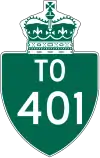
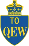
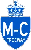
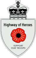
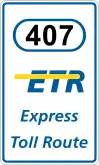
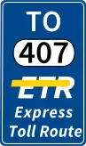
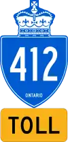
In addition to regular highway shields, there are other schemes used for directions to highways or special designations for specific 400-series highways: Trailblazer signs, which indicating a route "TO" a highway, are green with white lettering, with the exception of trailblazers indicating directions to the QEW, which are dark blue with yellow lettering. These also exist in the junction sign format. In addition to the aforementioned distinct colours used for the QEW and provincial tolled routes, Highway 401 formerly had many "Macdonald-Cartier Freeway" shields posted alongside the standard route marker (although most have now been removed), and since August 2004, has "Highway of Heroes" shields featuring a diagram of a poppy, between Toronto and CFB Trenton. These were erected to honour fallen Canadian soldiers, whose bodies were repatriated from Afghanistan in funeral convoys along that stretch of the highway.[10] The privately owned section of Highway 407, 407 ETR, uses a white rectangular marker with the highway number in a capsule, with the words "Express Toll Route" and the ETR logo below; trailblazers are blue with white lettering. The government-owned toll roads of Highway 407, Highway 412, and Highway 418 use a blue shield with white lettering, along with a yellow tab which says "TOLL" in black.
Speed limits
Ontario's first provincial legislation governing automobile use came into effect in 1903, which included a 15 mph (25 km/h) speed limit. The first provincial Highway Traffic Act passed in 1923 changed the speed limit for highways to 25 mph (40 km/h).[11]
Limits were later increased, for rural roads, to 50 mph (80 km/h) and then again to 60 mph (97 km/h). In 1968 the maximum speed limit for freeways was raised to 70 mph (113 km/h). In 1976 the maximum speed limit for freeways was reduced to 60 mph (97 km/h), while the rural limit was reduced to 50 mph (80 km/h), except for main highways running through northern Ontario which were reduced to 55 mph (89 km/h).
In 1977, highways started using the metric system with speeds being increased slightly to a maximum ranging from 80 km/h to 100 km/h (62 mph).
In 2013, "speed too fast / exceed speed limit" contributed to 18.4% of all collisions,[12] while "speeding" accounted for 55.2% of all driving convictions.[13] An Ontario-based group is lobbying to increase speed limits from 100 km/h to 130 km/h (81 mph).[14]
In 2015, the Ontario government announced a plan to reduce residential speed limits from the statutory default 50 km/h, either by reducing the statutory limit to 40 km/h or by giving municipalities the option to set their own statutory speed limits, as well as allowing posted speed limits in school zones to be lowered to 30 km/h.[15]
In mid-September 2019, speeds limits were increased to 110 km/h (68 mph) as part of a pilot across Highway 402 from London to Sarnia, the Queen Elizabeth Way from St. Catharines to Hamilton, and Highway 417 from Ottawa/Gloucester to the Ontario/Quebec border.[16]
Classification
Ontario has several distinct classes of highways:
King's Highways
The King's Highways are currently numbered 2 to 427.[17] The Ministry of Transportation never designated a Highway 1. Some highway numbers are suffixed with a letter A ("alternate route"), B ("business route"), or S ("scenic route"). In the past, there have also been routes with letters C and D (thought to stand for "connector" and "diversion", respectively) and even one instance of a road with a T suffix.[17]
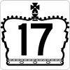
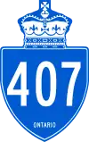
King's Highway markers take on one of two designs depending on placement: Standard road highway markers placed along the highway itself consist of the route number in black on a white shield design topped with a St Edward's Crown. Junction signs (used at intersections, ramp signs, and on overhead signs on freeways) use a white silhouette of the St Edward's Crown with the route number in it. The current design features the highway number and the word "Ontario" on the shield. Signs prior to 1993 had the words "The King's Highway" below the crown, but current versions have the words removed. Older signs were made of ceramic, but now are made of metal.
White-on-green Trans-Canada Highway markers are used on King's Highways designated as the national route, and are posted below the standard provincial marker.
The speed limit on King's Highways is generally 80 km/h (50 mph) in rural areas and 50 km/h (31 mph) in urban areas. On rural portions of the Trans-Canada Highway, on RIRO and at-grade expressways, and on certain other highways in Northern Ontario, the speed limit is 90 km/h (56 mph).
400-series highways
400-series highways are a special class of King's Highways, designed to be exclusively controlled-access freeways for the entire length of the highway. At present, all of them are located in Southern Ontario, where they form a network similar to the Interstate Highway System in the US. The 400-series highways include Highways 400, 401, 402, 403, 404, 405, 406, 407, 409, 410, 412, 416, 417, 418, 420, 427, and the QEW. Originally, 400-series route numbers were assigned sequentially, but more recently new routes have been numbered based on the existing highway the new route bypassed or upgraded. (Highway 427 is an upgrade of Highway 27, for example.)
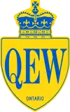
Despite their special status, they use the same shield colour as regular King's Highways, with the exceptions of the Queen Elizabeth Way (QEW), which uses blue "QEW" lettering on a yellow background, and the provincially-maintained tolled 400-series routes use a white-on-blue scheme with an orange tab reading "Toll" in black below the main shield.
Although the province also maintains freeways that match 400-series standards, such as the Conestoga Parkway, they are not designated with a 400-series number, even though some of those freeways exceed some existing 400-series highways in size and traffic volume and are in some cases connected to the 400-series network. Nonetheless, Ontario freeways do not receive a 400-series number unless they are designed to be complete controlled-access freeways for their whole length. While at-grade intersections existed on Highway 406 for many years, construction took place from 2008 to 2015 to close off intersections or replace them with overpasses and interchanges, bringing the route to full freeway standards. The non 400-series routes typically have open-access portions besides the freeway section, while the freeway segment is typically a small section not at the route's termini. 400-series standards do allow for 400-series highways to begin or end at roundabouts or traffic lights, such as Highway 406, Highway 410 and Highway 420 respectively.
The 400-series highways are designed to the highest specifications of any provincial highways, with typical design speeds of 100–130 km/h. Nearly all 400-series highways have posted speeds of 100 km/h, although in a few instances, speeds are lower, usually to account for dangerous or obsolete-design areas. For example, Highway 403 near Hamilton is signed at 90 km/h because of a series of sharp curves, and Highway 402 is signed at 70 km/h on the final approach to the border crossing at the Blue Water Bridge in Sarnia because of heavy, backed-up or stopped truck traffic.
Secondary
Secondary highways exist in Northern Ontario (and used to exist in Central and Eastern Ontario) to connect towns and remote areas, often connecting small to large towns to major Kings Highways. These highways are currently numbered from 502 to 673. Secondary highway markers are trapezoid-shaped. On the face of the marker appear, from top to bottom: the Ontario coat of arms, the word "ONTARIO", and the number of the highway.
A few secondary highways remain gravel-surfaced, although most have been paved. The speed limit on nearly all of these routes is 80 km/h (50 mph), although Highway 655 is posted at 90 km/h (56 mph). The majority of length in the secondary highway system consists of a single continuous yellow centerline, though some segments are up to King's highway standards either because they serve as a quick connector to them (like Highway 655), or because they are former alignments of King's Highways, or because they approach an intersection with a King's Highway.
The Secondary Highway system was introduced in 1955 to service regions in Northern and Central Ontario, but parts of the system were decommissioned from the provincial highway network in 1997 and 1998. In Northern Ontario, where there is no county-level system of government to take over road maintenance, secondary highways are still in operation and serve a function analogous to that of a county road, while those in Southern Ontario have all been downloaded to the counties and rolled into the county road systems there.
Tertiary
Tertiary roads connect those regions in northern Ontario not served by secondary highways. Legally, "road" has the same meaning as highway.[3] These roads are currently numbered 801 to 811, and are marked by a simple rectangular marker with rounded corners bearing the number of the highway and the word "Ontario". Most of these roads are gravel-surfaced and low-standard. The speed limit on these routes is 80 km/h (50 mph), although design standards generally override such.
The Ministry of Transportation introduced the Tertiary Road system in 1962. These roads were mostly resource access roads generally built into remote areas in Northern Ontario. These roads were constructed in small numbers, and with one exception (Highway 802), do not end at a settlement. Most of these Tertiary Roads were later upgraded and rebuilt to Secondary Highway standards. At present, there are only five tertiary roads in Ontario. All are gravel roads, except for Hwy 802 and Hwy 805, which both have some paved sections.
Trans-Canada
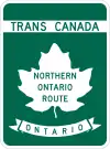
The Trans-Canada Highway follows various provincial highways. It is signed with the distinctive white-on-green TCH shield used in the rest of Canada, placed below the provincial shield. As the TCH lacks a national numeric designation in the province, the signs are numberless, but are often marked with designated route names; examples being the Georgian Bay Route and the Northern Ontario Route.
Others
In addition to these three classes of highways, the Ministry of Transportation maintains other roads, such as resource roads or industrial roads, that are of strategic importance to the Ministry, but which are not important enough to be given any special marking. These roads are designated with 7000-series numbers for internal inventory purposes, though they are not publicly marked as such. These are frequently, but not always, former highway segments which lost their original highway designation but remain important as connecting routes to communities or other highways.
As a further note, some roads are designated as 7000-series highways but are discontinuous, connected by "non-assumed" roads (roads not under provincial control, such as county roads, or town streets), linking both parts that share the same number.
Also, in Southern Ontario and in the city of Greater Sudbury there are systems of regional, municipal or county roads that are also numbered. These roads are maintained by the local government (Township, City, or County/Region), not by the province.
There are also several formerly designated Ontario Tourist Routes that were located throughout the entire province, but these have since become harder to find, as many signs have been taken down. There are also "Historic Colonization Roads" throughout eastern and central Ontario, shown on maps and on street signs. See List of Ontario Historic Colonization Roads for more information.
Transfers
As part of a series of budget cuts initiated by premier Mike Harris under his Common Sense Revolution platform in 1995, numerous highways deemed to no longer be of significance to the provincial network were decommissioned and responsibility for the routes transferred to lower levels of government, a process referred to as downloading. Several thousand kilometres of provincially maintained highways were transfered to the various municipalities in which they are located. These transfers were performed under the reasoning that they served a mostly local function, as a cost-saving measure and as part of a broader exchange of responsibilities between the province and its municipalities.
On April 1, 1997, 1,767.6 kilometres (1,098.3 mi) of highways were removed from the King's Highway system.[18] This was followed by the removal of 3,211.1 kilometres (1,995.3 mi) on January 1, 1998,[19] for a total of 4,978.7 kilometres (3,093.6 mi).
See also
| Wikimedia Commons has media related to Highways in Ontario. |
References
- How we clear Ontario’s highways in winter
- Shragge, John; Bagnato, Sharon (1984). From Footpaths to Freeways. Toronto: Ontario Ministry of Transportation and Communications, Historical Committee. pp. 74–75. ISBN 978-0-7743-9388-1.
- Public Transportation and Highway Improvement Act; R.S.O. 1990, Chapter P.50
- Highway Traffic Act; R.S.O. 1990, Chapter H.8
- Don W. Thompson (1969). Men and Meridians: The History of Surveying and Mapping in Canada. Volume 3: 1917 to 1947. Canadian Government Publishing Centre. p. 141. ISBN 0-660-00359-7.
- "Design Approved". The Globe. November 2, 1929. p. 2.
- Municipal Act, 2001; SO 2001, c. 25
- Provincially Maintained Highways
- Conservation Authorities Act; R.R.O. 1990, Regulation 164, Amended to O. Reg. 172/06
- "Stretch of 401 to be renamed 'Highway of Heroes'". CTV Toronto. August 24, 2007. Archived from the original on January 6, 2011. Retrieved February 3, 2010.
- Government of Ontario, Ministry of Transportation. "History of Monistry of Transportation". www.mto.gov.on.ca.
- "Table 2.8: Apparent Driver Action by Class of Collision, 2013" (PDF). Ontario Ministry of Transportation. 2014. Archived (PDF) from the original on May 16, 2017.
- "Table 7.2: Motor Vehicle Convictions Related to the Highway Traffic Act, 2013" (PDF). Ontario Ministry of Transportation. 2014. Archived (PDF) from the original on May 16, 2017.
- "Ontario org. wants highway speed limits increased from 100 km/h". April 18, 2012. Archived from the original on April 22, 2012.
- "Lower residential speed limit considered by Ontario government". CBC News Ottawa. January 29, 2015. Archived from the original on December 4, 2015. Retrieved December 9, 2015.
- "Ontario Introduces Speed Limit Pilots and Consultations". news.ontario.ca.
- TheKingsHighway.ca
- Highway Transfers List - "Who Does What" (Report). Ministry of Transportation of Ontario. June 20, 2001.
- Highway Transfers List - "Who Does What" (Report). Ministry of Transportation of Ontario. June 20, 2001. pp. 7–8.
External links
- Ministry of Transportation of Ontario (MTO)
- MTO 100th Anniversary - History
- Official Ontario road map
- Ontario 511 Traveller Information - Highway conditions
- Ontario's Highway Programs
- Road maps of Ontario, 1923–2010
- OntHighways at AsphaltPlanet - Photos of Ontario Highways
- History of The King's Highways


|