Oranjestad, Sint Eustatius
Oranjestad (Dutch pronunciation: [oːˈrɑɲəstɑt]; English: Orange[3] Town) is a small town of approximately 1,000 inhabitants; it is the capital of the island of Sint Eustatius in the Caribbean Netherlands.
Oranjestad | |
|---|---|
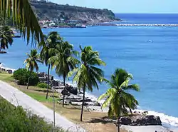
 Beach of Lower Town. | |
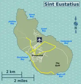
 Location on the island of Sint Eustatius | |
| Coordinates: 17°29′N 62°59′W | |
| Country | Netherlands |
| Public body | Sint Eustatius |
| Time zone | UTC-4 (AST) |
| Climate | Aw |
 | |

| |
| Location | Oranjestad Sint Eustatius |
|---|---|
| Coordinates | 17°29′01.7″N 62°59′13.1″W |
| Year first constructed | 1893 (first) |
| Foundation | concrete base |
| Construction | metal skeletal tower |
| Tower shape | square pyramidal skeletal tower with balcony and light |
| Tower height | 20 metres (66 ft) |
| Focal height | 40 metres (130 ft) |
| Light source | solar power |
| Range | 17 nautical miles (31 km; 20 mi) |
| Characteristic | Fl (3) W 15s. |
| Admiralty number | J5668.5 |
| NGA number | 14742[1][2] |
Geography
Oranjestad is a historic harbour town which is divided into two main sections. Lower Town is a strip of buildings just above sea level along the waterfront, which borders on the island's safest beach. Lower Town includes dive shops, numerous colonial-era ruins, and the harbour. Upper Town has a restored historic core, and is also the island's main commercial and residential centre.
Climate
| Climate data for Oranjestad, Sint Eustatius (1971-2000) | |||||||||||||
|---|---|---|---|---|---|---|---|---|---|---|---|---|---|
| Month | Jan | Feb | Mar | Apr | May | Jun | Jul | Aug | Sep | Oct | Nov | Dec | Year |
| Average high °C (°F) | 28.3 (82.9) |
28.4 (83.1) |
28.8 (83.8) |
29.4 (84.9) |
30.1 (86.2) |
30.8 (87.4) |
31.1 (88.0) |
31.2 (88.2) |
31.0 (87.8) |
30.6 (87.1) |
29.8 (85.6) |
28.7 (83.7) |
29.9 (85.7) |
| Daily mean °C (°F) | 25.3 (77.5) |
25.2 (77.4) |
25.5 (77.9) |
26.2 (79.2) |
27.1 (80.8) |
27.9 (82.2) |
28.0 (82.4) |
28.1 (82.6) |
27.9 (82.2) |
27.4 (81.3) |
26.6 (79.9) |
25.5 (77.9) |
26.7 (80.1) |
| Average low °C (°F) | 22.5 (72.5) |
22.3 (72.1) |
22.7 (72.9) |
23.3 (73.9) |
24.1 (75.4) |
25.0 (77.0) |
24.9 (76.8) |
25.0 (77.0) |
24.7 (76.5) |
24.4 (75.9) |
23.7 (74.7) |
23.1 (73.6) |
23.8 (74.9) |
| Average rainfall mm (inches) | 52.0 (2.05) |
50.5 (1.99) |
48.8 (1.92) |
55.7 (2.19) |
87.1 (3.43) |
60.6 (2.39) |
74.1 (2.92) |
106.9 (4.21) |
123.2 (4.85) |
106.5 (4.19) |
128.6 (5.06) |
74.6 (2.94) |
985.8 (38.81) |
| Average rainy days (≥ 1.0 mm) | 11.1 | 8.9 | 7.6 | 7.4 | 9.5 | 7.4 | 11.2 | 12.1 | 12.2 | 11.2 | 13.3 | 12.6 | 125.4 |
| Source: Meteo Curacao[4] | |||||||||||||
History
Historical sites


The main historical site in Oranjestad is Fort Oranje, a well-maintained, 17th-century fort in the direct centre of the town, overlooking the waterfront. This cliffside fort has cannons, intact bastions and a courtyard. Nearby is a museum, the ruins of one of the oldest synagogues in the Western Hemisphere, and a Jewish cemetery.
The town's historical features also include a Dutch Reformed church built in 1755, which is partly in ruins but still accessible (its tower can be climbed for long-distance views), various restored 18th-century merchants’ residences – including the oldest one, the Gezaghebber House (former Lieutenant Governor's residence) on Kerkstraat – and restored wooden Caribbean-style houses. Snorkeling in Oranje Bay is also interesting because of the parts of 18th century buildings on the bay side that were swept into the sea.
Facilities
Oranjestad itself contains grocery stores, restaurants, bars, a library, schools, a clinic and the administrative offices of the government.
References
- Sint Eustatius The Lighthouse Directory. University of North Carolina at Chapel Hill. Retrieved 27 January 2017
- List of Lights, Pub. 110: Greenland, The East Coasts of North and South America (Excluding Continental U.S.A. Except the East Coast of Florida) and the West Indies (PDF). List of Lights. United States National Geospatial-Intelligence Agency. 2016.
- The House of Orange-Nassau — Dutch: Het Huis Oranje-Nassau — read Prince of Orange (Dutch: Prins van Oranje) and related articles for more.
- "SUMMARY OF CLIMATOLOGICAL DATA, PERIOD 1971 - 2000" (PDF). Meteo Curacao. Retrieved May 21, 2020.
External links
| Wikimedia Commons has media related to Oranjestad, Sint Eustatius. |