Oregon Route 99
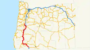
Oregon Route 99 is a state highway that runs between the southern border of Oregon, and the city of Junction City. Oregon Route 99 was formed from parts of the former U.S. Route 99; it shares much of its route with Interstate 5, but much of it is also independent. Between Portland and Junction City, the highway is forked into two routes: Oregon Route 99E and Oregon Route 99W.
| ||||
|---|---|---|---|---|
 | ||||
| Route information | ||||
| Maintained by ODOT | ||||
| Length | 211 mi (340 km) | |||
| Existed | 1972–present | |||
| Major junctions | ||||
| South end | ||||
| North end | ||||
| Highway system | ||||
| ||||

Route description
Oregon Route 99 technically starts at an interchange with Interstate 5 at exit 11, south of Ashland. There it departs from the freeway, running parallel to I-5 as it passes through the cities of Ashland (as Main Street), Talent, Phoenix, and Medford. The highway rejoins I-5 at exit 35, just northwest of Central Point.
OR 99 departs from I-5 several more times through the mountains of southern Oregon, only to rejoin again a short distance later. Junctions are found in Gold Hill (2nd Ave), Grants Pass, between Myrtle Creek and Sutherlin (crossing I-5 in Roseburg), through Drain and Yoncalla, and Cottage Grove and Goshen. These departures serve as business routes for I-5, as Oregon does not have or sign Interstate business routes.
When it reaches Eugene, OR 99 departs from I-5 for a final time. It heads west into downtown, along Franklin Boulevard past the University of Oregon. Downtown, OR 99 is on the 6th and 7th Avenue couplet. (Much of the section in Eugene is co-signed with either Oregon Route 126 or OR 126 Business.) West of downtown it heads north on an expressway alignment, which continues to Junction City. In Junction City, OR 99 ends, as it splits into eastern and western forks.
Highways comprised
OR 99 comprises the following named highways (see Oregon highways and routes) and roads, from south to north:
- The Rogue Valley Highway No. 63;
- Part of the Pacific Highway No. 1 (concurrent with I-5);
- The Gold Hill Spur No. 486;
- The Sams Valley Highway No. 271 (concurrent with OR 234);
- The Rogue River Highway No. 60;
- Part of the Redwood Highway No. 25;
- Part of the Pacific Highway (concurrent with I-5);
- Part of Fifth Street in Canyonville;
- Part of the Tiller-Trail Highway No. 230;
- Part of the Pacific Highway (concurrent with I-5);
- The Dillard Highway, which is no longer a state highway;
- Part of the Coos Bay-Roseburg Highway No. 35 (concurrent with OR 42);
- The Oakland-Shady Highway, which is no longer a state highway (concurrent with OR 138);
- Part of the Pacific Highway (concurrent with I-5);
- The Drain-Yoncalla Highway, which is no longer a state highway;
- Part of the Umpqua Highway No. 45;
- Part of the Pacific Highway (concurrent with I-5);
- The Goshen-Divide Highway No. 226;
- Part of the Pacific Highway (concurrent with I-5); and
- Part of the Pacific Highway West No. 1W.
It followed the Myrtle Creek Highway previously. This section was removed by 2018.[1]
Major intersections
| County | Location | mi[2] | km | Exit | Destinations | Notes |
|---|---|---|---|---|---|---|
| Jackson | | 0.00 | 0.00 | |||
| Ashland | 3.48 | 5.60 | ||||
| Medford | 18.64 | 30.00 | ||||
| | 23.85 | 38.38 | Blackwell Road | Former US 99 north | ||
| | 24.12 | 38.82 | 35 | Southern end of I-5 overlap | ||
| | 29.47 | 47.43 | 40 | Northern end of I-5 overlap | ||
| | 29.79 | 47.94 | Blackwell Road | Former US 99 south | ||
| Gold Hill | 30.19 | 48.59 | Southern end of OR 234 overlap | |||
| | 32.85 | 52.87 | Northern end of OR 234 overlap | |||
| | 34.73 | 55.89 | Interchange | |||
| Josephine | Grants Pass | 47.17 | 75.91 | |||
| 47.35 | 76.20 | |||||
| 47.37– 47.58 | 76.23– 76.57 | Seventh Street Bridge (northbound) and Caveman Bridge (southbound) over the Rogue River | ||||
| 48.15 | 77.49 | Former Redwood Spur | ||||
| 48.28 | 77.70 | E Street | Former Rogue River Loop Highway | |||
| 49.94 | 80.37 | 58 | Southern end of I-5 overlap | |||
| | 53.31 | 85.79 | 61 | Merlin | ||
| | 58.15 | 93.58 | 66 | Hugo | ||
| | 60.95 | 98.09 | Sexton Mountain Pass summit, elevation 1,960 ft or 600 m | |||
| | 63.26 | 101.81 | 71 | Sunny Valley | ||
| | 65.68 | 105.70 | Smith Hill summit, elevation 1,730 ft or 530 m | |||
| Wolf Creek | 67.90– 68.47 | 109.27– 110.19 | 76 | Wolf Creek | ||
| | 69.98 | 112.62 | 78 | Speaker Road | Southbound exit and northbound entrance | |
| | 71.68 | 115.36 | Stage Road Pass summit, elevation 1,830 ft or 560 m | |||
| Douglas | | 72.66 | 116.93 | 80 | Glendale | |
| | 75.12 | 120.89 | 83 | Barton Road | Northbound exit and southbound entrance | |
| Quines Creek | 77.97 | 125.48 | 86 | Quines Creek Road / Barton Road | Barton Road only appears on southbound signage | |
| | 79.95 | 128.67 | 88 | Azalea, Galesville Reservoir | ||
| | 82.03 | 132.01 | Canyon Creek Pass summit, elevation 2,020 ft or 620 m | |||
| | 87.65 | 141.06 | 95 | Canyon Creek | ||
| Canyonville | 89.93 | 144.73 | 98 | Northern end of I-5 overlap | ||
| | 93.40 | 150.31 | 101 | Southern end of I-5 overlap | ||
| | 93.98 | 151.25 | 102 | Gazley Road | ||
| Tri-City | 96.04 | 154.56 | 103 | Northern end of I-5 overlap | ||
| Myrtle Creek | 101.29 | 163.01 | 108 | Southern end of I-5 overlap | ||
| | 103.30 | 166.25 | 110 | Boomer Hill Road | ||
| | 105.07– 105.17 | 169.09– 169.25 | 112 | Northern end of I-5 overlap | ||
| Winston | 114.00 | 183.47 | Southern end of OR 42 overlap | |||
| | 116.85 | 188.05 | Northern end of OR 42 overlap | |||
| | 117.97 | 189.85 | No access to northbound I-5 | |||
| Roseburg | 121.67 | 195.81 | Southern end of OR 138 overlap | |||
| 121.91 | 196.20 | North end of OR 138 overlap | ||||
| Winchester | 127.50 | 205.19 | ||||
| Sutherlin | 135.00 | 217.26 | ||||
| | 139.23 | 224.07 | 140 | Southern end of I-5 overlap; southbound exit and northbound entrance | ||
| | 140.89 | 226.74 | 142 | Metz Hill | ||
| | 144.96 | 233.29 | 146 | Rice Valley | ||
| Rice Hill | 147.15– 148.34 | 236.81– 238.73 | 148 | Rice Hill | ||
| | 149.04 | 239.86 | 150 | Northern end of I-5 overlap | ||
| Drain | 156.86 | 252.44 | Southern end of OR 38 overlap | |||
| | 162.88 | 262.13 | Curtin Road – Anlauf, Lorane | Former Territorial Highway | ||
| Anlauf | 163.52 | 263.16 | 162 | Northern end of OR 38 overlap; south end of I-5 overlap | ||
| | 164.59 | 264.88 | 163 | Curtin, Lorane | ||
| Lane | | 169.91 | 273.44 | 170 | Northern end of I-5 overlap; northbound exit and southbound entrance | |
| Creswell | 183.79 | 295.78 | ||||
| | 189.53 | 305.02 | ||||
| 189.90 | 305.61 | Franklin Boulevard | Former US 99 north | |||
| 188B | Southern end of I-5 overlap | |||||
| | 190.94– 191.58 | 307.29– 308.32 | 189 | 30th Avenue (OR 225) – South Eugene | Former US 99 north | |
| Springfield–Eugene line | 193.05 | 310.68 | 191 | OR 126 Bus. only appears on northbound signage | ||
| Eugene | 193.63 | 311.62 | 192 | Northern end of I-5 overlap; northbound exit and southbound entrance | ||
| 193.71 | 311.75 | Riverview Street | Interchange; no southbound entrance | |||
| 194.22 | 312.57 | Interchange; southern end of OR 126 Bus. overlap; southbound exit and northbound entrance; former US 99 south | ||||
| 195.66 | 314.88 | Interchange | ||||
| 196.38 | 316.04 | Interchange; northern end of OR 126 Bus. overlap; southern end of OR 126 overlap | ||||
| 196.63 | 316.45 | Blair Boulevard | Former Junction City–Eugene Highway | |||
| 197.47 | 317.80 | Northern end of OR 126 overlap | ||||
| | 201.31 | 323.98 | Interchange | |||
| | 208.45 | 335.47 | ||||
| Junction City | 209.97 | 337.91 | 1st Avenue to High Pass Road – Santa Clara | Former Junction City–Eugene Highway | ||
| 211.00 | 339.57 | |||||
1.000 mi = 1.609 km; 1.000 km = 0.621 mi
| ||||||
References
- (PDF) https://www.oregon.gov/ODOT/Data/Documents/Map_Official_State_Front.pdf. Missing or empty
|title=(help) - "Road Assets and Mileage". Oregon Department of Transportation. Retrieved January 14, 2021.