Springfield, Oregon
Springfield is a city in Lane County, Oregon, United States. Located in the Southern Willamette Valley, it is within the Eugene-Springfield Metropolitan Statistical Area. Separated from Eugene to the west, mainly by Interstate 5, Springfield is the second-most populous city in the metropolitan area after Eugene. As of the 2010 census, the city has a total population of 59,403.[7]
Springfield | |
|---|---|
City | |
| Springfield, Oregon | |
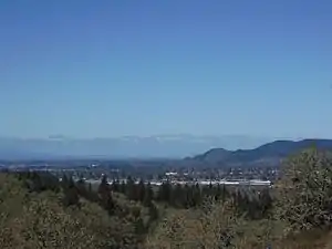 Springfield as seen from Mount Pisgah, looking north, with some of Eugene in the west | |
| Motto(s): "Proud History, Bright Future." | |
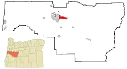 Location in Oregon | |
 Springfield Location in the United States | |
| Coordinates: 44°3′11″N 122°59′28″W | |
| Country | United States |
| State | Oregon |
| County | Lane |
| Incorporated | 1885 |
| Government | |
| • Type | Council–manager |
| • Mayor | Christine Lundberg[1] |
| • City manager | Gino Grimaldi |
| Area | |
| • Total | 15.84 sq mi (41.02 km2) |
| • Land | 15.84 sq mi (41.02 km2) |
| • Water | 0.00 sq mi (0.00 km2) |
| Elevation | 454 ft (138.4 m) |
| Population | |
| • Total | 59,403 |
| • Estimate (2019)[4] | 63,230 |
| • Density | 3,992.55/sq mi (1,541.50/km2) |
| Time zone | UTC-8 (Pacific) |
| • Summer (DST) | UTC-7 (Pacific) |
| ZIP codes | 97475, 97477, 97478, 97482 |
| Area code(s) | 458 and 541 |
| FIPS code | 41-69600[5] |
| GNIS feature ID | 1127456[6] |
| Website | City of Springfield |
The Briggs family first settled the Springfield area, arriving in 1848. The community was incorporated as a city in 1885. The city was named after a natural spring located in a field or prairie within the current city boundaries.[8] For the majority of the 20th century the economy of Springfield was largely dependent on the Oregon timber industry, but since the 1990s the economy has diversified with PeaceHealth now the largest employer in the city. Public education in the city is provided by the Springfield School District.
History
The first inhabitants to the area were the Kalapuya people. Also sometimes written as Calapooia or Calapooya, the people maintained the valley and their main food sources by controlled burning.[9]
Springfield was settled when Elias and Mary Briggs and their family arrived in 1848. They were among the first party to travel to the region via the "Southern Route" by Klamath Lake, over the Cascades, into the Rogue Valley, then north to the Willamette Valley.[10] Elias Briggs along with William Stevens ran a ferry on the nearby Willamette River.
According to donation land claim records, Stevens was the first settler to stake a claim in the Springfield locale, arriving in October 1847. He commenced building a house with his three oldest sons, and when the house was completed in December, the rest of his family joined him on Christmas Day that year.
Another early arrival in the Springfield vicinity was Captain Felix Scott, Sr. who settled between the McKenzie and Willamette rivers in 1847.
In 1854 Springfield School District No. 19 was formed. A small schoolhouse was built near the corner of south 7th and B streets; it served the community until the 1880s. Miss Agnes Stewart, a young woman from Pennsylvania, was the first teacher. She had arrived in Springfield via the Lost Wagon Train of 1853.
In May 1992 the municipality became the first in the United States to include anti-gay legislation in its city charter after a campaign by the Oregon Citizens Alliance.[11] However, the state legislature later passed a law that prevented anti-gay ordinances from being enforced.[12]
Economy
For years, the economy of Springfield hinged on the timber industry, with the largest employer being Weyerhaeuser Company. Weyerhaeuser opened its Springfield complex in 1949, and after years of aggressive logging was forced to downsize as old growth lumber became less available. In the 1990s, the Weyerhaeuser sawmill and veneer (plywood) plants closed, and the paper plant was downsized. Springfield has now developed a more diversified economy.
Ken Kesey's brother Chuck, and Chuck's wife Sue, started the Springfield Creamery in 1960. The business survives today based partly on sales of their flagship product, Nancy's Yogurt, developed from recipes of Nancy Hamren. In the 1970s, the creamery avoided bankruptcy with the help of the rock band Grateful Dead, who over time held a series of 10 benefit concerts on behalf of the creamery. The documentary film Sunshine Daydream was shot at the first performance August 27, 1972.[13][14]
The city of Springfield is surrounded by filbert (hazelnut) orchards. The production has declined over time as fields have been developed into housing. The city used to be sponsor an annual Filbert Festival in early August as a general summer celebration, featuring music, food, and family fun; it was canceled in 2007 due to withdrawal of a key sponsor, and the future for the festival is uncertain. Filbert harvesting occurs in October. 98% of American filbert production is harvested in the Willamette Valley.[15]
Healthcare
Springfield is home to two hospitals, McKenzie-Willamette Medical Center and PeaceHealth's Sacred Heart Medical Center at RiverBend.
Largest employers
According to the City's 2018 Comprehensive Annual Financial Report,[16] the largest employers in the city are:
| Rank | Employer | # of Employees |
|---|---|---|
| 1 | PeaceHealth | 3,500 |
| 2 | Springfield School District | 1,380 |
| 3 | "Top 3 Technology employers" | 1,200 |
| 4 | McKenzie-Willamette Medical Center | 940 |
| 5 | "Top 3 Wood product employers" | 780 |
| 6 | "Top 3 Food and beverage employers" | 410 |
| 7 | City of Springfield | 400 |
| 8 | Willamalane Park and Recreation District | 360 |
| 9 | State Government | 310 |
| 10 | Federal Government | 207 |
Government
Springfield has a council–manager form of government. The current mayor of Springfield is Christine Lundberg,[1] and the city manager is Gino Grimaldi.[17] The city council comprises members from 6 wards.[18] The current council members are:[18]
- Ward 1: Sean Van Gordon
- Ward 2: Steve Moe
- Ward 3: Sheri Moore
- Ward 4: Leonard Stoehr
- Ward 5: Marilee Woodrow
- Ward 6: Joe Pishioneri (City Council President)
Public safety
The Springfield Police Department and Eugene Springfield Fire are the city's public safety agencies.[19][20]
Geography
According to the United States Census Bureau, the city has a total area of 15.75 square miles (40.79 km2), of which, 15.74 square miles (40.77 km2) is land and 0.01 square miles (0.03 km2) is water.[21]
The McKenzie River forms the northern city limits.
Neighborhoods
Springfield does not have any official neighborhood designations. Unofficial neighborhood areas include:
- Gateway
- Glenwood
- North Springfield
- Thurston
- Washburne Historic District, listed on the National Register of Historic Places
- Meadow Park
- Kelly Butte
- West Kelly Butte
Demographics
| Historical population | |||
|---|---|---|---|
| Census | Pop. | %± | |
| 1860 | 198 | — | |
| 1870 | 200 | 1.0% | |
| 1880 | 160 | −20.0% | |
| 1890 | 371 | 131.9% | |
| 1900 | 353 | −4.9% | |
| 1910 | 1,838 | 420.7% | |
| 1920 | 1,855 | 0.9% | |
| 1930 | 2,364 | 27.4% | |
| 1940 | 3,805 | 61.0% | |
| 1950 | 10,807 | 184.0% | |
| 1960 | 19,616 | 81.5% | |
| 1970 | 27,047 | 37.9% | |
| 1980 | 41,624 | 53.9% | |
| 1990 | 44,683 | 7.3% | |
| 2000 | 52,864 | 18.3% | |
| 2010 | 59,403 | 12.4% | |
| 2019 (est.) | 63,230 | [4] | 6.4% |
| Source:[7][22] 2018 Estimate[24] | |||
2010 census
As of the census[3] of 2010, there were 59,403 people, 23,665 households, and 14,737 families residing in the city. The population density was 3,774.0 inhabitants per square mile (1,457.1/km2). There were 24,809 housing units at an average density of 1,576.2 per square mile (608.6/km2). The racial makeup of the city was 85.9% White, 1.1% African American, 1.4% Native American, 1.3% Asian, 0.3% Pacific Islander, 5.2% from other races, and 4.8% from two or more races. Hispanic or Latino of any race were 12.1% of the population.
There were 23,665 households, of which 33.2% had children under the age of 18 living with them, 40.9% were married couples living together, 15.2% had a female householder with no husband present, 6.2% had a male householder with no wife present, and 37.7% were non-families. 27.9% of all households were made up of individuals, and 9.2% had someone living alone who was 65 years of age or older. The average household size was 2.49 and the average family size was 3.00.
The median age in the city was 34.5 years. 24.3% of residents were under the age of 18; 10.1% were between the ages of 18 and 24; 29% were from 25 to 44; 25% were from 45 to 64; and 11.6% were 65 years of age or older. The gender makeup of the city was 49.0% male and 51.0% female.
Arts and culture
Author Ken Kesey moved to Springfield when he was young and graduated from Springfield High School before moving on to the nearby University of Oregon. After some years of wandering (described in The Electric Kool-Aid Acid Test by Tom Wolfe), Kesey bought a farm in nearby Pleasant Hill and remained a prominent local celebrity until his death in 2001.
Library
The Springfield Public Library is located within city hall.[25]
Cultural venues
The Richard E. Wildish Community Theater on Main Street in downtown Springfield, a complete renovation of the historic McKenzie Theater, opened in December 2006. The theater seats 284 people and is designed to host music concerts and recitals, dance, drama, festivals and small musicals. The Springfield Renaissance Development Corporation spearheaded the six-year renovation project, completed at a cost of $3.1 million.[26]
Education
There are 15 elementary, 4 middle, and 4 high schools in the Springfield School District, making it one of the largest in the state.[27][28] The largest public high schools, by enrollment, are Thurston High School and Springfield High School. Pioneer Pacific College also has a campus in the Gateway area of Springfield.[29]
In popular culture
The Simpsons
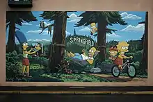
The city took third in the voting to choose one of the sixteen possible Springfields in the U.S. to host the premiere of The Simpsons Movie.[30] The show's creator, Oregon resident Matt Groening, sent a plaque to the city of Springfield that stated, in part "Yo to Springfield, Oregon – the real Springfield."[31] In April 2012, Groening confirmed to Smithsonian magazine that he named the fictional Springfield after Springfield, Oregon. He also confirmed that he intentionally left it a secret to allow people the enjoyment of assuming it was based on their own Springfield.[32]
Notable people
- Sheila Bleck, IFBB professional bodybuilder
- Colby Covington, Mixed Martial Arts Fighter
- Peter DeFazio, U.S. Representative for Oregon's 4th congressional district
- Bill Dellinger, Olympic athlete and former University of Oregon track coach
- Diane Downs, child murderer arrested and jailed in Springfield
- Ken Kesey, author
- Kip Kinkel, perpetrator of the Thurston High School shooting
- Eric Millegan, Broadway and television actor
- Mickey Newbury, American songwriter, recording artist, member Nashville Songwriters Hall of Fame
- Steve Reeves, Actor and body builder
- Travis Smith, major league baseball player
- Dan Straily (born 1988), starting pitcher in the Philadelphia Phillies organization
- Robert W. Straub, Oregon governor
- Theodore Sturgeon, science fiction author
- Shoshana R. Ungerleider, physician and film producer
Climate
This region experiences warm (but not hot) and dry summers, with no average monthly temperatures above 71.6 °F (22.0 °C). According to the Köppen Climate Classification system, Springfield has a warm-summer Mediterranean climate, abbreviated "Csb" on climate maps.[33]
References
- Palmer, Susan (December 7, 2010). "Lundberg selected Springfield mayor". The Register-Guard. Eugene, Ore. Retrieved December 8, 2010.
- "2019 U.S. Gazetteer Files". United States Census Bureau. Retrieved July 28, 2020.
- "U.S. Census website". United States Census Bureau. Retrieved December 21, 2012.
- "Population and Housing Unit Estimates". United States Census Bureau. May 24, 2020. Retrieved May 27, 2020.
- "U.S. Census website". United States Census Bureau. Retrieved January 31, 2008.
- "US Board on Geographic Names". United States Geological Survey. October 25, 2007. Retrieved January 31, 2008.
- "American FactFinder: Oregon population". U.S. Census Bureau. Retrieved March 3, 2011.
- "Names of Lane County Communities Reveal Interesting Histories, Anecdotes". Eugene Register-Guard. January 4, 1942. p. 4. Retrieved April 23, 2015.
- "Fire in Early Oregon". Oregon Encyclopedia.
- "Early History of Springfield, Oregon". City of Springfield.
- "Oregon to vote on plan to allow bias against gays. Conservative group forces a referendum". The Baltimore Sun. New York Times News Service. August 16, 1992. Retrieved April 10, 2011.
The campaign was used successfully by Mr. Mabon's group in May, when the Oregon town of Springfield voted, by 55 percent to 45 percent, to become the nation's first municipality to include anti-gay language in its city charter.
- Neville, Paul (April 13, 1995). "Appeals court deals setback to gay rights foes". Eugene Register-Guard. Eugene, Oregon. p. 1. Retrieved April 10, 2011.
The Oregon Court of Appeals upheld a state law Wednesday that bars cities and counties from enforcing anti-gay rights ordinances.
- Blair Jackson (2012). "Review of Sunshine Daydream". Blair's Golden Road Blog.
- Diane Dietz (September 6, 2010). "50 years in the creamery". Register-Guard.
We had some debts that had to get paid, so we said, "Well, what do you think? Do you think the Dead would come up and do a benefit concert for us?" My brother-in-law (and Chuck's brother) Ken Kesey said, "I don't know why not. You might as well ask them."
- http://www.uga.edu/fruit/hazelnut.html uga.edu
- "City of Springfield 2018 Comprehensive Annual Financial Report" (PDF).
- "Springfield City Manager's Office".
- "City Council and Wards". City of Springfield, Oregon.
- "SPD Website".
- "Eugene Springfield Fire website".
- "US Gazetteer files 2010". United States Census Bureau. Archived from the original on January 24, 2012. Retrieved December 21, 2012.
- Moffatt, Riley. Population History of Western U.S. Cities & Towns, 1850–1990. Lanham: Scarecrow, 1996, 216.
- United States Census Bureau. "Census of Population and Housing". Retrieved September 26, 2014.
- "Population Estimates". United States Census Bureau. Retrieved June 8, 2018.
- "SPL Downtown City Hall".
- Glucklich, Elon. "Nonprofit pursues Terese’s Place building." Register Guard. 10 November 2017. https://www.registerguard.com/rg/news/local/36131690-75/springfield-development-nonprofit-eyes-retail-building-next-to-widlish-theater.html.csp
- "SPS". Archived from the original on March 26, 2010.
- "SPS- Homepage". Archived from the original on September 3, 2011.
- "PPC".
- "Springfields Vie For "Simpsons" Premiere Archived March 11, 2007, at the Wayback Machine." CBS News. March 9, 2007. Retrieved on March 9, 2007.
- The Register-Guard, Eugene, Oregon, USA
- De La Roca, Claudia (May 2012). "Matt Groening Reveals the Location of the Real Springfield". Smithsonian. Retrieved November 9, 2013.
- Climate Summary for Springfield, Oregon
External links
| Wikimedia Commons has media related to Springfield, Oregon. |
- City of Springfield official website
- Springfield Chamber of Commerce
- Entry for Springfield in the Oregon Blue Book
Municipalities and communities of Lane County, Oregon, United States | ||
|---|---|---|
| Cities |  Lane County map | |
| Unincorporated communities |
| |
| Ghost towns | ||
| Indian reservation | ||
| Footnotes | ‡This populated place also has portions in an adjacent county or counties | |
| ||

| Authority control |
|---|
