Outline of Somaliland
The following outline is provided as an overview and topical guide to Somaliland:
.svg.png.webp)
Map of Somaliland
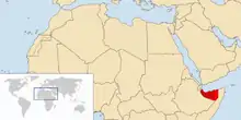
The location of Somaliland
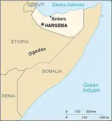
An enlargeable map of Somaliland
Blank map of Somaliland
Somaliland – is an internationally unrecognised country.[1] The government of Somaliland regards the territory as the successor state to the British Somaliland protectorate, which was independent for a few days in 1960 as the State of Somaliland,[2][3] before voluntarily uniting with the Trust Territory of Somalia (the former Italian Somaliland) later the same week to form the Somali Republic.[2][3][4][5][6]
General reference
- Common English regional name: Somaliland
- Common endonym(s)
- Somali: Soomaaliland
- Arabic: أرض الصومال
- ISO country code: +2526
- ISO region code: +2526
- Internet country code top-level domain: http://somalilandsun.com
Geography of Somaliland
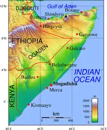
An enlargeable topographic map of Somaliland within Somalia.
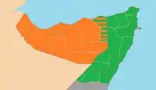
Location of Somaliland
- Republic of Somaliland is situated within the following regions:
- Eastern Hemisphere and Southern Hemisphere
- Africa
- Horn of Africa
- Republic of Somaliland is regarded internationally as a fully autonomous country claimed by Somalia, although it meets all criteria of Montevideo Convention.[7][8]
- Horn of Africa
- Time zone: East Africa Time (UTC+03)
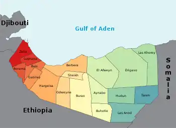
Administrative divisions

Regions of Somaliland
Map of Somaliland districts

Outline of Somaliland clans
| Key | Region | Capital | Area km² |
Population density km2 |
|---|---|---|---|---|
| 1 | Awdal | Borama | n/a | n/a |
| 2 | Saaxil | Berbera | n/a | n/a[9] |
| 3 | Togdheer | Burao | n/a | n/a |
| 4 | Sool | Las Anod | n/a | n/a |
| 5 | Sanaag | Erigavo | n/a | n/a |
| 6 | Maroodi Jeex | Hargeisa | n/a | n/a |
The main cities and towns in Somaliland:
- Hargeisa (Hargeysa), capital
- Boorama (Borama)
- Berbera
- Burco (Burao)
- Ceerigaabo (Erigabo)
- Dilla
- Las Anod (Laascaanood)
- Gabiley (Gabileh)
- Baligubadle
- Zeila (Saylac)
- Odweyne
- Yubbe
- Badhan
- Lasqoray
| State | Capital | Annexed |
|---|---|---|
| Gabiley | Gabiley | Maroodi Jeex |
| Maakhir | Badhan | Sanaag |
| Cayn | Buhoodle | Togdheer |
| Salal | Zeila | Awdal |
| Sarar | Caynaba | Sool |
| Odweyne | Odweyne | Togdheer |
| Hawd | Baligubadle | Maroodi Jeex |
The regions are divided into eighteen administrative districts.
Districts of Somaliland
Government and politics of Somaliland
Dispute updated as of December 2016
- Form of government:
- Capital of Somaliland: Hargeisa
- Elections in Somaliland
- Political parties in Somaliland
Executive branch
- Heads of state: Presidents of Somaliland
Legislative branch
Foreign relations of Somaliland
Foreign relations of Somaliland
- Diplomatic missions in Somaliland
- Diplomatic missions of Somaliland
International organization membership
- None[10]
Law and order within Somaliland
Military of Somaliland
History of Somaliland
Culture of Somaliland
- Culture of Somaliland
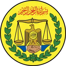
- Coat of arms of Somaliland
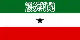
- Flag of Somaliland
- Somaliland national football team
Economy and infrastructure of Somaliland
- Currency of Somaliland: Shilling
- Telecommunications in Somaliland
- Transport in Somaliland
See also
References
- "The Transitional Federal Charter of the Somali Republic" (PDF). University of Pretoria. 2004-02-01. Archived from the original (PDF) on 2008-12-18. Retrieved 2010-02-02. "The Somali Republic shall have the following boundaries. (a) North; Gulf of Aden. (b) North West; Djibouti. (c) West; Ethiopia. (d) South south-west; Kenya. (e) East; Indian Ocean."
- "Somaliland Marks Independence After 73 Years of British Rule" (fee required). The New York Times. 1960-06-26. p. 6. Retrieved 2008-06-20.
- "How Britain said farewell to its Empire". BBC News. 2010-07-23.
- Encyclopædia Britannica, The New Encyclopædia Britannica, (Encyclopædia Britannica: 2002), p.835
- "The dawn of the Somali nation-state in 1960". Buluugleey.com. Archived from the original on 2009-01-16. Retrieved 2009-02-25.
- "The making of a Somalia state". Strategypage.com. 2006-08-09. Retrieved 2009-02-25.
- "The Transitional Federal Charter of the Somali Republic" (PDF). University of Pretoria. 2004-02-01. Archived from the original (PDF) on 2008-12-18. Retrieved 2010-02-02. "The Somali Republic shall have the following boundaries. (a) North; Gulf of Aden. (b) North West; Djibouti. (c) West; Ethiopia. (d) South south-west; Kenya. (e) East; Indian Ocean."
- Gettleman, Jeffrey (2009-06-02). "No Winner Seen in Somalia's Battle With Chaos". New York Times. Retrieved 2010-02-02.
- Somaliland Constitution
- CIA - The World Factbook - Somalia
External links
| Somali language edition of Wikipedia, the free encyclopedia |
| Arabic language edition of Wikipedia, the free encyclopedia |
- Somaliland official website
- Democracy Comes of Age in Somaliland Contemporary Review, 2005, Stefan Simanowitz
- Somaliland BBC Country Profile
- Somaliland - Interest free but not yet Shari’ah-compliant economy
- United Kingdom parliamentary debate on recognition of Somaliland, February 4, 2004 led by Tony Worthington
- Somaliland recognition finds enhanced support
This article is issued from Wikipedia. The text is licensed under Creative Commons - Attribution - Sharealike. Additional terms may apply for the media files.