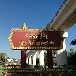
Pakokku
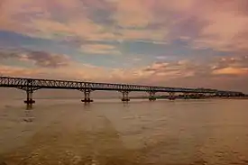
Pakokku (Burmese: ပခုက္ကူမြို့, [pəkʰoʊʔkù]) is a largest city in the Magway Region in Myanmar, also known as Burma. It is situated about 30 km north-east of Bagan on the Irrawaddy River. It is the administration seat of Pakokku Township , Pakokku District and Gangaw District. Pakokku Bridge is part of the India–Myanmar–Thailand Trilateral Highway and is the longest bridge in Myanmar.It is home of the Pakokku airport.
Pakokku
ပခုက္ကူမြို့ | |
|---|---|
City | |
| Myanma transcription(s) | |
| • Burmese | pa.hkukku mrui. |
 | |
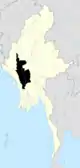
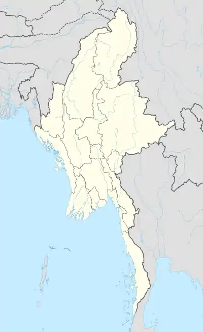 Pakokku Location in Burma | |
| Coordinates: 21°20′N 95°54′E | |
| Country | |
| Region | |
| District | Pakokku District |
| Township | Pakokku Township |
| Population (2014) | |
| • City | 322,154[1] |
| • Urban | 107,557 |
| • Metro | 214,597 |
| Time zone | UTC+6.30 (MST) |
The city is the location of Computer University, Pakokku, Pakokku Education College, Technological University, Pakokku, and Pakokku University. Thiho Shin Pagoda(The Lord of Sri Lanka Pagoda), Shwe Ku Pagoda, Shwe Mothtaw Pagoda,Shwe Tant Tit, and Phaung Taw Oo Pagoda are famous pagodas which locate at Pakokku. Irrawaddy Bridge (Pakokku) is the longest bridge in Myanmar.Pakokku is also the largest rice market city of Upper Myanmar(Burma).
History
Before British occupation, Pakokku was a small village and part of Pakhangyi District and Bagan District. The British occupied Upper Burma on 29 November 1885. On 1 December 1887, British India Government established Pakokku Municipal. On 21 December 1887, British India government ordered Pakokku as a town of Pakhangyi District with the population of 1,985. By the order degree (201) of British Government, Pakhangyi District was abolished and Pakokku District was established on 21 July 1888. In 1901,the population of Pakokku was 19,456. During 13 years,Pakokku's population and developments were increased rapidly.
In 1896,Pakokku became a capital city of Pakokku Hill Tracts Districts’’’ (including Pakokku District, Chin State(except Paletwa township), Gangaw District, Naga Self-Administered Zone, Nagaland, Mizoram, Tripura, Manipur and Meghalaya(except Shillong township)).
In the early months of 1930,Political speeches were held in Shwegu Pagoda for Burma's colonial separation from British India.U Lwin was appointed a new mayor of Pakokku on 7 November 1930. Pakokku Municipal election was held on 10 December 1930. In the early morning of 22 March 1931, heavy fire burned in Pakokku and more than 3,000 people were homeless. So,Pakokku Fire brigade was established on 7 April 1931.
When Myanmar(Burma) was independence in 1948,Pakokku Hill Tracts Districts was divided into two sections. Pakokku District, Gangaw District, Naga Self-Administered Zone and Chin State became a Parts of Myanmar(Burma) and Nagaland, Mizoram, Tripura, Manipur and Meghalaya became a parts of India.
By 1947 Construction of the union of Burma,Pakokku province was established with two districts in 1948. They are Pakokku District and Kanpetlet District with 11 townships. Townships are Pakokku, Kanpetlet, Yesagyo, Pauk, Seikphyu, Myaing, Gangaw, Htilin, Saw, Mindat and Matupi.Pakokku was occupied by Communist rebels in 1949 and held until 1955, when it was liberated by government forces. In 1958,the name of Kanpetlet District was changed into Mindat District and Kanpetlet District's Capital was moved to Mindat from Kanpetlet. Province's Capital city was Pakokku.
On 2 March 1962, the military led by General Ne Win took control of Burma through a coup d'état, and the government has been under direct or indirect control by the military. A new constitution of the Socialist Republic of the Union of Burma was adopted in 1974.
By 1974 construction, Pakokku province was abolished and Pakokku District was added to the Magway Division and Mindat District was added to the Chin State until now. On 4 April 1998,Pakokku District was divided into two districts. Pakokku, Pauk, Yesagyo, Myaing and Seikphyu became Pakokku District and Gangaw, Saw and Htilin became Gangaw District.
Pakokku Bridge construction was started on 15 December 2009 and ended on 31 December 2011. It was opened on 1 January 2012, and is the longest bridge in Myanmar.
Notable Places
Climate
| Climate data for Pakokku (1981–2010) | |||||||||||||
|---|---|---|---|---|---|---|---|---|---|---|---|---|---|
| Month | Jan | Feb | Mar | Apr | May | Jun | Jul | Aug | Sep | Oct | Nov | Dec | Year |
| Average high °C (°F) | 29.1 (84.4) |
32.3 (90.1) |
36.4 (97.5) |
39.0 (102.2) |
37.5 (99.5) |
35.3 (95.5) |
34.9 (94.8) |
33.9 (93.0) |
33.5 (92.3) |
32.7 (90.9) |
30.6 (87.1) |
28.7 (83.7) |
33.7 (92.7) |
| Average low °C (°F) | 13.2 (55.8) |
14.7 (58.5) |
18.6 (65.5) |
22.1 (71.8) |
24.2 (75.6) |
23.6 (74.5) |
23.8 (74.8) |
23.5 (74.3) |
23.0 (73.4) |
21.6 (70.9) |
18.1 (64.6) |
15.1 (59.2) |
20.1 (68.2) |
| Average rainfall mm (inches) | 0.9 (0.04) |
0.3 (0.01) |
3.9 (0.15) |
11.1 (0.44) |
88.2 (3.47) |
89.7 (3.53) |
38.2 (1.50) |
90.6 (3.57) |
117.8 (4.64) |
132.0 (5.20) |
29.6 (1.17) |
4.0 (0.16) |
606.3 (23.87) |
| Source: Norwegian Meteorological Institute[2] | |||||||||||||
Transport
Pakokku's strategic location in Central Burma makes it an important hub for transport of people and goods. The city is connected to other parts of the country and to China,Thailand and India by multiple modes of transportation.
Air
River
The Ayeyarwady River remains an important arterial route for transporting goods such as farm produce including rice, beans and pulses, cooking oil, pottery, bamboo and teak. Pakokku river port is one of the most important ports, the third largest port in Myanmar (Burma) after Yangon port and Mandalay port. Pakokku port is a major port of Magway Region.
Rail
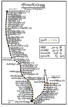
Division 10 Pakokku
Pakokku Railway Station is the terminus of Myanmar Railways's main rail line from Yangon and the starting point of branch lines to Pyin U Lwin (Maymyo), Monywa, Mandalay, Kalay, Gangaw, and to the south, Bagan, Minbu, Thayet, Pyay and Kyangin.Pakokku Railway Station is the major Railway Station of Magwe Division.
Pakokku does not have an intra-city metro rail system.
Roads
Pakokku is a part of Burma's road network. The highway network includes roads towards:[4]
- Upper Burma and China—
Pakokku—Myingyan-Mandalay-Tagaung–Bhamo–Myitkyina Road, Pakokku-Chaung Oo-Sagaing-Mandalay Road, Pakokku-Mandalay–Lashio–Muse Road (part of Asian Highway)[5]
- Western Burma and India—
Pakokku-Pauk-Saw-Htilin-Gangaw-Kale-Tamu Road, Pakokku-Pauk-Kyaukhtu-Mindat-Matupi Road, Pakokku—Chaung Oo–Monywa–Kalewa–Tamu Road(part of India–Myanmar–Thailand Trilateral Highway)[5]
- Lower Burma and Thailand—
Pakokku-Nyaung-Oo-Chauk-Pyay-Bago-Yangon Road, Pakokku-Meiktila – Nay Pyi Taw – Thaton – Hpa-an – Kawkareik – Myawaddy Road(part of India–Myanmar–Thailand Trilateral Highway)[5]
Most stretches of these highways are one-lane roads in poor condition. Pakokku Bridge is part of the India–Myanmar–Thailand Trilateral Highway and is the longest bridge in Myanmar.
Economy
Pakokku Industrial Zone
The Largest Rice Market of Upper Myanmar
Pakokku is the biggest rice market in Upper Myanmar due to the rice requirement of the region itself and being a door to Chin State which also needs rice. Of the incoming rice to Pakokku, 70% is from the Ayeyawady Region (Myaungmya, Hinthada and Myanaung) and 30% is from Shwebo and Ye-U of the Sagaing Region. Some 20% of rice coming into the market of Pakokku is consumed by Pakokku itself, and the remaining 80% is sent to other township markets. Most buyers are from Myaing, Yesagyo, Pauk, Kalaymyo and Chin State. In the Pakokku market, consumption is 15% for top class, 50% for middle class and 35% for lower class rice. There are about 5 large rice wholesalers and 10 small rice wholesalers. A large rice wholesaler sells 500 to 1,500 bags per day, so it can sell 180,000 to 200,000 bags (9,000-10,000 tons) a year. Due to the smooth transportation and the booming market, the rice price becomes very high. Thus, the rice market in Pakokku has increased to double that of the Mandalay market.
Education
List of universities and colleges in Pakokku
- Pakokku Teacher Training Degree College (Pakokku Education Degree College)
- Pakokku University
- Computer University, Pakokku
- Technological University, Pakokku
- Nursing College, Pakokku
- East Pali University of Buddhism, Pakokku(Maha Vijara Rama)
- Middle Pali University of Buddhism, Pakokku (Maha Visuta Rama)
- West Pali University of Buddhism, Pakokku (Mandalay tike)
List Of Ethnic Groups In Pakokku
Religion
Religion in Pakokku (2014)[6]
Buddhism is the practised by the majority of the population. A sizable minority, however, adheres to Islam, Christianity, Atheist, and Hinduism.
Pakokku is the second most important and populated city of Buddhist monks in Myanmar (Burma) with three Pali university of Buddhism.
Health care
Public Hospitals
- Pakokku General Hospital
- Pakokku Traditional Medicine Hospital
- Pakokku Women's and Children's Hospital
- Pakokku Sangha Hospital
Private Hospitals
- ChanMyae Hospital
- ThaPyaeNyo Hospital
Future Plans
- Pakokku Airport as an international Airport
- Pakokku Inland port development project in Irrawaddy River
- A new bus terminal as a largest bus terminal in Upper Myanmar
- Fuel Refineries economic Zone
- Shopping Malls and Supermarkets
- Pakokku-Bagan Circular high speed Railway
References
- Census Report. The 2014 Myanmar Population and Housing Census. 2. Naypyitaw: Ministry of Immigration and Population. May 2015.
- "Myanmar Climate Report" (PDF). Norwegian Meteorological Institute. pp. 23–36. Archived from the original (PDF) on 8 October 2018. Retrieved 1 December 2018.
- Division 10 Pakokku
- Thiha Aung (13 February 2005). "Mandalay Division marching to new golden land of unity and amity". New Light of Myanmar.
- "Asian Highway in Myanmar" (PDF). unescap.org. Retrieved 12 January 2009.
- Department of Population Ministry of Labour, Immigration and Population MYANMAR (July 2016). The 2014 Myanmar Population and Housing Census Census Report Volume 2-C. Department of Population Ministry of Labour, Immigration and Population MYANMAR. pp. 12–15.
Capital: Magway | ||
| Gangaw District |
|   |
| Magway District | ||
| Minbu District | ||
| Pakokku District | ||
| Thayet District |
| |
| Main cities and towns | ||