Panay
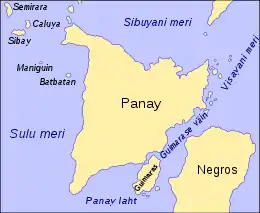
Panay is the sixth-largest and fourth most-populous island in the Philippines, with a total land area of 12,011 km2 (4,637 sq mi) and with a total population of 4,477,247 as of 2015. Panay comprises 4.4 percent of the entire population of the country.[1] The City of Iloilo is its largest settlement with a total population of 447,992 inhabitants. It is a triangular island, located in the western part of the Visayas. It is about 160 km (99 mi) across. It is divided into four provinces: Aklan, Antique, Capiz and Iloilo, all in the Western Visayas Region. Just closely off the mid-southeastern coast lies the island-province of Guimaras. It is located southeast of the island of Mindoro and northwest of Negros across the Guimaras Strait. To the north and northeast is the Sibuyan Sea, Jintotolo Channel and the island-provinces of Romblon and Masbate; to the west and southwest is the Sulu Sea and the Palawan archipelago[2] and to the south is Panay Gulf. Panay is the only main island in the Visayas whose provinces don't bear the name of their island.
 | |
.svg.png.webp) Panay Location within the Philippines | |
| Geography | |
|---|---|
| Location | South East Asia |
| Coordinates | 11°09′N 122°29′E |
| Archipelago | Visayas |
| Adjacent bodies of water | |
| Area | 12,011 km2 (4,637 sq mi) |
| Area rank | 65th |
| Coastline | 764 km (474.7 mi) |
| Highest elevation | 2,117 m (6946 ft) |
| Highest point | Mount Madja-as |
| Administration | |
Philippines | |
| Region | Western Visayas |
| Provinces | |
| Largest settlement | Iloilo City (pop. 447,992) |
| Demographics | |
| Population | 4,477,247 (2015) |
| Pop. density | 349.0/km2 (903.9/sq mi) |
| Ethnic groups | |
Panay is bisected by the Central Panay Mountain Range, its longest mountain chain. The island has many rivers, the longest being the Panay River at a length of 168 kilometres (104 mi), followed by the Jalaur, Aklan, Sibalom, Iloilo and Bugang rivers. Standing at about 2,117 m (6,946 ft), the dormant Mount Madja-as (situated in Culasi, Antique) is the highest point of the island, with Mount Nangtud (located between Barbaza, Antique and Jamindan, Capiz) following next at 2,073 m (6,801 ft).
History
Etymology
Before 1212, Panay was called Simsiman. The community is located at the shores of the Ulian River and was linked by a creek. The creek provided salt to the Ati people as well as animals which lick the salt out of the salty water. Coming from the root word "simsim", "simsimin" means "to lick something to eat or to drink", thus the place was called Simsiman.
The native Ati called the island Aninipay from words "ani" to harvest and "nipay", a hairy grass abundant in the whole Panay.
Before the arrival of the Europeans
No pre-Hispanic written accounts of Iloilo and Panay island exist today. Oral traditions, in the form of recited epics like the Hinilawod, has survived to a small degree. A few recordings of these epic poems exist. The most notable are the works of noted Filipino Anthropologist Felipe Jocano.[3]
While no current archaeological evidence exist describing pre-Hispanic Panay, an original work by Pedro Alcantara Monteclaro published in 1907 called Maragtas details the alleged accounts of the founding of the various pre-Hispanic polities on Panay Island. The book is based on oral and written accounts available to the author at the time.[4] The author made no claim on the historical accuracy of the accounts.[5]
According to Maragtas, the Kedatuan of Madja-as was founded after ten datus fled Borneo and landed on Panay Island. The book then goes on to detail their subsequent purchase of the coastal lands in which they settled from the native Ati people.


An old manuscript Margitas of uncertain date (discovered by the anthropologist H. Otley Beyer)[6] give interesting details about the laws, government, social customs, and religious beliefs of the early Visayans, who settled Panay within the first half of the thirteenth century.[7] The term Visayan was first applied only to them and to their settlements eastward in the island of Negros, and northward in the smaller islands, which now compose the province of Romblon. In fact, even at the early part of Spanish colonialization of the Philippines, the Spaniards used the term Visayan only for these areas. While the people of Cebu, Bohol, and Leyte were for a long time known only as Pintados. The name Visayan was later extended to them because, as several of the early writers state, their languages are closely allied to the Visayan dialect of Panay.[8]
Grabiel Ribera, captain of the Spanish royal infantry in the Philippine Islands, also distinguished Panay from the rest of the Pintados Islands. In his report (dated 20 March 1579) regarding a campaign to pacify the natives living along the rivers of Mindanao (a mission he received from Dr. Francisco de Sande, Governor and Captain-General of the Archipelago), Ribera mentioned that his aim was to make the inhabitants of that island "vassals of King Don Felipe… as are all the natives of the island of Panay, the Pintados Islands, and those of the island of Luzon…"[9]
During the early part of the colonial period in the Archipelago, the Spaniards led by Miguel López de Legazpi transferred their camp from Cebu to Panay in 1569. On 5 June 1569, Guido de Lavezaris, the royal treasurer in the Archipelago, wrote to Philip II reporting about the Portuguese attack to Cebu in the preceding autumn. A letter from another official, Andres de Mirandaola (dated three days later, 8 June), also described briefly this encounter with the Portuguese. The danger of another attack led the Spaniards to remove their camp from Cebu to Panay, which they considered a safer place. Legazpi himself, in his report to the Viceroy in New Spain (dated 1 July 1569), mentioned the same reason for the relocation of Spaniards to Panay.[10] It was in Panay that the conquest of Luzon was planned, and later launched on 8 May 1570.[11]
The account of early Spanish explorers
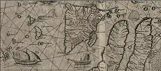
During the early part of the Spanish colonization of the Philippines, the Spanish Augustinian Friar Gaspar de San Agustín, O.S.A. described Panay as: "…very similar to that of Sicily in its triangular form, as well as in it fertility and abundance of provision. It is the most populated island after Manila and Mindanao, and one of the largest (with over a hundred leagues of coastline). In terms of fertility and abundance, it is the first. […] It is very beautiful, very pleasant, and full of coconut palms… Near the river Alaguer (Halaur), which empties into the sea two leagues from the town of Dumangas…, in the ancient times, there was a trading center and a court of the most illustrious nobility in the whole island."[12] Padre Francisco Colin (1592-1660), an early Jesuit missionary and Provincial of his Order in the Philippines also records in the chronicles of the Society of Jesus (published later in 1663 as Labor euangelica) that Panay is the island which is most abundant and fertile.[13]
The first Spanish settlement in Panay island and the second oldest Spanish settlement in the Philippines was established by the Miguel Lopez de Legazpi expedition in Panay, Capiz at the banks of the Panay River[14] in northern Panay, the name of which was extended to the whole Panay island. Legazpi transferred the capital there from Cebu since it had abundant provisions and was better protected from Portuguese attacks before the capital was once again transferred to Manila.[15]
Miguel de Luarca, who was among the first Spanish settlers in the Island, made one of the earliest account about Panay and its people according to a Westerner's point of view. In June 1582, while he was in Arevalo (Iloilo), he wrote in his Relacion de las Yslas Filipinas the following observations:
The island is the most fertile and well-provisioned of all the islands discovered, except the island of Luzon: for it is exceedingly fertile, and abounds in rice, swine, fowls, wax, and honey; it produces also a great quantity of cotton and abacá fiber.[16]
"The villages are very close together, and the people are peaceful and open to conversion. The land is healthful and well-provisioned, so that the Spaniards who are stricken in other islands go thither to recover their health."[16]
"The natives are healthy and clean, and although the island of Cebu is also healthful and had a good climate, most of its inhabitants are always afflicted with the itch and buboes. In the island of Panay, the natives declare that no one of them had ever been afflicted with buboes until the people from Bohol – who, as we said above, abandoned Bohol on account of the people of Maluco – came to settle in Panay, and gave the disease to some of the natives. For these reasons the governor, Don Gonzalo Ronquillo, founded the town of Arevalo, on the south side of this island; for the island runs north and south, and on that side live the majority of the people, and the villages are near this town, and the land here is more fertile."[16] This probably explains why there are reference of presence of Pintados in the Island.
"The island of Panay provides the city of Manila and other places with a large quantity of rice and meat…".[17].. "As the island contains great abundance of timber and provisions, it has almost continuously had a shipyard on it, as is the case of the town of Arevalo, for galleys and fragatas. Here the ship 'Visaya' was launched."[18]
Another Spanish chronicler in the early Spanish period, Dr. Antonio de Morga (Year 1609) is also responsible for recording other Visayan customs. Customs such as Visayans' affinity for singing among their warrior-castes as well as the playing of gongs and bells in naval battles.
Their customary method of trading was by bartering one thing for another, such as food, cloth, cattle, fowls, lands, houses, fields, slaves, fishing-grounds, and palm-trees (both nipa and wild). Sometimes a price intervened, which was paid in gold, as agreed upon, or in metal bells brought from China. These bells they regard as precious jewels; they resemble large pans and are very sonorous. They play upon these at their feasts, and carry them to the war in their boats instead of drums and other instruments.[19]
The early Dutch fleet commander Cornelis Matelieff de Jonge called at Panay in 1607. He mentions a town named "Oton" on the island where there were "18 Spanish soldiers with a number of other Spanish inhabitants so that there may be 40 whites in all". He explained that "a lot of rice and meat is produced there, with which they [i.e. the Spanish] supply Manila."[20]
According to Stephanie J. Mawson, using recruitment records found in Mexico, in addition to the 40 Caucasian Spaniards who then lived in Oton, there were an additional set of 66 Mexican soldiers of Mulatto, Mestizo or Native American descent sentried there during the year 1603.[21] However, the Dutch visitor, Cornelis Matelieff de Jongedid, did not count them in since they were not pure whites like him.
Iloilo City in Panay was awarded by the Queen of Spain the title: "La Muy Leal y Noble Ciudad de Iloilo (The Most Loyal and Noble City) for being the most loyal and noble city in the Spanish Empire since it clung on to Spain amidst the Philippine revolution the last nation to revolt against Spain in the Spanish Empire.
Nearby Boracay island was considered the most beautiful island in the world by several travel magazines.
The island lent its name to several United States Navy vessels including the USS Panay (PR-5), sunk in 1937 by the Japanese in the Panay incident.
World War II
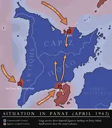
Panay was a target by the Japanese in order to secure the rest of Visayas and so on April 16, 1942, Imperial Japanese Army forces landed on San Jose de Buenavista, Capiz City and Iloilo City.
However, guerrilla forces under Col. Macario Peralta Jr. would later on liberate most of the island and eventually capturing the city of Capiz on December 20, 1944 and therefore the liberation of the entire Capiz Province before the Allied forces land on Iloilo City on March 18, 1945 where they mopprd up the remaining Japanese forces in the island.[22]
Geography
Panay island is the sixth largest island in the Philippines by area, with a total land area of 12,011 km2 (4,637 sq mi) and with a total coastline of 764 km (475 mi). Mount Madja-as is the highest point in Panay with an elevation of 6,946 feet (2,117 m ) above sea level, located in town of Culasi in the northern province of Antique. Central Panay Mountain Range is the longest and largest mountain range in the island with a total length of 170 km (110 mi) north-south. Panay River is the longest river in the island with a total length of 168 km (104 mi) located in the province of Capiz.
Boracay island, with a white sand beach is located 0.86 kilometres (0.53 miles) off the coast of northwest tip of Panay Island, it is part of Aklan province, is a popular tourist destination.
Topography
Panay island List of highest Peaks by elevation
- Mount Madja-as 6,946 ft (2,117 m)
- Mount Nangtud 6,804 ft (2,074 m)
- Mount Baloy 6,424 ft (1,958 m)
- Mount Balabag 5,630 ft (1,720 m)
- Mount Nausang 5,410 ft (1,650 m)
- Mount Inaman 5,200 ft (1,600 m)
- Mount Agbalanti 5,187 ft (1,581 m)
- Mount Tigas 4,974 ft (1,516 m)
- Mount Sonogong 4,836 ft (1,474 m)
- Mount Igbanig 4,813 ft (1,467 m)
- Mount Sipanag 4,757 ft (1,450 m)
- Mount Tiguran 4,524 ft (1,379 m)
- Mount Igdalig 4,521 ft (1,378 m)
- Mount Tigatay 4,436 ft (1,352 m)
- Mount Llorente 4,409 ft (1,344 m)
- Mount Tiran 4,347 ft (1,325 m)
- Mount Dumara 4,340 ft (1,320 m)
- Mount Bucayan 4,310 ft (1,314 m)
- Mt. Agua Colonia 4,304 ft (1,312 m)
- Mount Taripis 4,265 ft (1,300 m)
- Mount Opao 4,252 ft (1,296 m)
- Mount Sansanan 4,219 ft (1,286 m)
- Mount Napulak 4,095 ft (1,248 m)
- Mount Tiglayo 4,078 ft (1,243 m)
- Mount Lingguhob 3,970 ft (1,210 m)
- Mount Bantolinao 3,970 ft (1,210 m)
- Mount Tigbayot 3,943 ft (1,202 m)
- Mount Tibtib 3,927 ft (1,197 m)
- Mount Tambara 3,920 ft (1,190 m)
- Mount Balabag 3,728 ft (1,136 m)
- Mount Parali 3,665 ft (1,117 m)
- Mount Tulajon 3,593 ft (1,095 m)
- Mount Anoy 3,510 ft (1,070 m)
- Mount Usigan 3,507 ft (1,069 m)
- Mount Congcong 3,442 ft (1,049 m)
- Mount Manlabog 3,310 ft (1,010 m)
- Mount Igmatindog 3,281 ft (1,000 m)
- Mount Angas 3,277 ft (999 m)
- Mount Patag 3,240 ft (990 m)
- Mount Toctocan 3,166 ft (965 m)
- Mount Palaypay 3,077 ft (938 m)
- Mount Igcalaya 3,067 ft (935 m)
- Mount Dalangnan 3,022 ft (921 m)
- Mount Igpanalan 2,979 ft (908 m)
- Mount Igdu-ao 2,854 ft (870 m)
- Mount Tuno 2,844 ft (867 m)
- Mount Tigancal 2,828 ft (862 m)
- Mount Balinsayaw 2,775 ft (846 m)
- Mount Dalyang 2,710 ft (830 m)
- Mount Igtiring 2,690 ft (820 m)
- Mount Igkobe 2,682 ft (817 m)
- Mount Dararas 2,682 ft (817 m)
- Mount Tigmaosin 2,641 ft (805 m)
- Mt. Pulak-pulakan 2,625 ft (800 m)
- Mt. Igmatongtong 2,624 ft (800 m)
River System
List of major river in Panay island by length.
- Panay River 168 km (104 mi)
- Jalaur River 141 km (88 mi)
- Aklan River 91 km (57 mi)
- Sibalom River 72.3 km (44.9 mi)
- Tigum River 71.5 km (44.4 mi)
- Paliwan River 57.9 km (36.0 mi)
- Kangaranan River 56.8 km (35.3 mi)
- Sibalom River 48.7 km (30.3 mi)
- Guimbal River 44.5 km (27.7 mi)
- Ibajay River 42.7 km (26.5 mi)
- Dalanas River 33.6 km (20.9 mi)
- Kairawan River 31.5 km (19.6 mi)
- Balantian River 30.4 km (18.9 mi)
- Patnongon River 29.2 km (18.1 mi)
- Barotac Viejo River 28.2 km (17.5 mi)
- Sara River 28.2 km (17.5 mi)
- Tangalan River 27 km (17 mi)
- Pres. Roxas River 26.7 km (16.6 mi)
- Siuaragan River 26.5 km (16.5 mi)
- Barotac Nuevo R. 26.5 km (16.5 mi)
- Tibiao River 25.3 km (15.7 mi)
- Banate River 23.4 km (14.5 mi)
- Tiolas River 20.3 km (12.6 mi)
- Tumagbok River 19.5 km (12.1 mi)
- Malandog River 17.8 km (11.1 mi)
- Oyungan River 16.9 km (10.5 mi)
- Iloilo River 16.2 km (10.1 mi)
- Bacong River 16.1 km (10.0 mi)
- Bayunan River 16 km (9.9 mi)
- Carit-an River 15.1 km (9.4 mi)
- Hamtic River 14.8 km (9.2 mi)
- Casay River 14.3 km (8.9 mi)
- Guinsang-an River 13.8 km (8.6 mi)
- Iba River 13.1 km (8.1 mi)
- Naulid River 12.7 km (7.9 mi)
- Bulanao River 12.3 km (7.6 mi)
- Aras-Asan River 11.5 km (7.1 mi)
- Bugasong River 11.4 km (7.1 mi)
- Inyawan River 11.4 km (7.1 mi)
- Unidos River 10.6 km (6.6 mi)
- Panganta River 10.4 km (6.5 mi)
- Paningayan River 10.4 km (6.5 mi)
- Binangbang River 10.4 km (6.5 mi)
- Bugang River 10.3 km (6.4 mi)
- Batiano River 10.2 km (6.3 mi)
- Baluon River 10.1 km (6.3 mi)
- Ajuy River 8.9 km (5.5 mi)
- Abiera River 8.7 km (5.4 mi)
- Dao River 8.6 km (5.3 mi)
- Igpasungaw River 8.2 km (5.1 mi)
- Aguila River 5.5 km (3.4 mi)
- Bitadnon River 5.4 km (3.4 mi)
- Alo River 5.3 km (3.3 mi)
- Igbarawan River 5.2 km (3.2 mi)
- Laua-an River 4.6 km (2.9 mi)
Waterfalls
List of Waterfalls in Panay Island.
- Tarugan Falls, Igbaras
- Nadsadjan Falls, Igbaras
- Lagsacan Falls, Igbaras
- Guiritsan Falls, Igbaras
- Miagos Falls, Igbaras
- Nasuraan Falls, Libacao
- Kamalasag Falls, Sebaste
- Igpasungaw Falls, Sebaste
- Tigmalmos Falls, Tibiao
- Ayu Falls, Igbaras
- pangitanan Falls, Libertad
- Sigbungon Falls, Barbaza
- Madangga Falls, Madalag
- Bugtong Bato Falls, Tibiao
- Macalbag Falls, Barbaza
- Tarayan Falls, Laua-an
- Cadiao Falls, Barbaza
- Igkataw Falls, Sebaste
Lakes
List of Lakes in Panay Island
- Lake Alapasco, Batad
- Lake Danao, San Remigio
- Marugo Lake, Tapaz, Capiz
- Tinagong Dagat, Lambunao
- Tinagong Dagat, Miag-ao
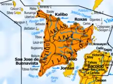
Administrative divisions
The island is covered by 4 provinces, 92 municipalities, and, as of 2014, 3 cities (93 municipalities if the associated islands of Caluya are included), all under the jurisdiction of the Western Visayas region.
| Seal | Province | Population (2015) [23][24] |
Land area | Population Density | Capital | Municipalities (including associated islands*) |
Cities | Location |
|---|---|---|---|---|---|---|---|---|
| Aklan | 574,823 | 1,821.42 km2 (703.25 sq mi) |
290/km2 (750/sq mi) |
Kalibo | 17 towns
|
— |  | |
| Antique | 582,012 | 2,729.17 km2 (1,053.74 sq mi) |
200/km2 (520/sq mi) |
San Jose de Buenavista | 18 towns
|
— |  | |
| Capiz | 761,384 | 2,594.64 km2 (1,001.80 sq mi) |
280/km2 (730/sq mi) |
Roxas | 16 towns
|
Roxas |  | |
 |
Iloilo | 2,384,415 | 5,079.17 km2 (1,961.08 sq mi) |
440/km2 (1,100/sq mi) |
Iloilo City | 42 towns
|
 | |
| Seal | Province | Population (2015) |
Land area | Density | Capital | Municipalities | Cities | Location |
|
Notes: The municipality of Caluya in Antique province is covered by separate islands which are included under the island group of Panay. Iloilo figures include the independent city of Iloilo. | ||||||||
References
- Boquet, Yves (2017). The Philippine Archipelago. Springer. p. 16. ISBN 9783319519265.
- C.Michael Hogan. 2011. Sulu Sea
- Jocano, Felipe Landa; Hugan-an (2000). Hinilawod: Adventures of Humadapnon Tarangban I. Quezon City: Punlad Research House, Inc. ISBN 971-622-010-3.
- Ma. Cecilia Locsin-Nava (2001). History & Society in the Novels of Ramon Muzones. Ateneo de Manila University Press. pp. 46. ISBN 978-971-550-378-5.
- Originally titled Maragtás kon (historia) sg pulô nga Panay kutub sg iya una nga pamuluyö tubtub sg pag-abut sg mga taga Borneo nga amó ang ginhalinan sg mga bisayâ kag sg pag-abut sg mga Katsilâ, Scott 1984, pp. 92–93, 103
- Scott, William Henry, Pre-hispanic Source Materials for the study of Philippine History, 1984: New Day Publishers, pp. 101, 296.
- G. Nye Steiger, H. Otley Beyer, Conrado Benitez, A History of the Orient, Oxford: 1929, Ginn and Company, p. 122.
- G. Nye Steiger, H. Otley Beyer, Conrado Benitez, A History of the Orient, Oxford: 1929, Ginn and Company, pp. 122–123.
- Cf. BLAIR, Emma Helen & ROBERTSON, James Alexander, eds. (1911). The Philippine Islands, 1493–1803. Volume 04 of 55 (1493–1803). Historical introduction and additional notes by Edward Gaylord BOURNE. Cleveland, Ohio: Arthur H. Clark Company. ISBN 978-0554259598. OCLC 769945704. "Explorations by early navigators, descriptions of the islands and their peoples, their history and records of the catholic missions, as related in contemporaneous books and manuscripts, showing the political, economic, commercial and religious conditions of those islands from their earliest relations with European nations to the beginning of the nineteenth century.", pp. 257–260.
- Cf. BLAIR, Emma Helen & ROBERTSON, James Alexander, eds. (1911). The Philippine Islands, 1493–1803. Volume 03 of 55 (1493–1803). Historical introduction and additional notes by Edward Gaylord BOURNE. Cleveland, Ohio: Arthur H. Clark Company. ISBN 978-0554259598. OCLC 769945704. "Explorations by early navigators, descriptions of the islands and their peoples, their history and records of the catholic missions, as related in contemporaneous books and manuscripts, showing the political, economic, commercial and religious conditions of those islands from their earliest relations with European nations to the beginning of the nineteenth century.", pp. 15–16.
- Cf. BLAIR, Emma Helen & ROBERTSON, James Alexander, eds. (1911). The Philippine Islands, 1493–1803. Volume 03 of 55 (1493–1803). Historical introduction and additional notes by Edward Gaylord BOURNE. Cleveland, Ohio: Arthur H. Clark Company. ISBN 978-0554259598. OCLC 769945704. "Explorations by early navigators, descriptions of the islands and their peoples, their history and records of the catholic missions, as related in contemporaneous books and manuscripts, showing the political, economic, commercial and religious conditions of those islands from their earliest relations with European nations to the beginning of the nineteenth century.", p. 73.
- Mamuel Merino, O.S.A., ed., Conquistas de las Islas Filipinas (1565–1615), Madrid: Consejo Superior de Investigaciones Cientificas, 1975, pp. 374–376.
- Francisco Colin, S.J., Labor euangelica, ministerios apostolicos de los obreros de la Compañia de Iesus : fundacion, y progressos de su Prouincia en las islas Filipinas historiados, Madrid:1663, Lib. I, Cap. VII, p. 63.
- Location of the Panay River Basin
- "The First Spanish Settlement in Panay" By Henry F. Funtecha PUBLISHED IN: The News Today.
- Miguel de Loarca, Relacion de las Yslas Filipinas (Arevalo: June 1582) in BLAIR, Emma Helen & ROBERTSON, James Alexander, eds. (1903). The Philippine Islands, 1493–1803. Volume 05 of 55 (1582–1583). Historical introduction and additional notes by Edward Gaylord BOURNE. Cleveland, Ohio: Arthur H. Clark Company. ISBN 978-0554259598. OCLC 769945704. "Explorations by early navigators, descriptions of the islands and their peoples, their history and records of the catholic missions, as related in contemporaneous books and manuscripts, showing the political, economic, commercial and religious conditions of those islands from their earliest relations with European nations to the beginning of the nineteenth century.", p. 67.
- Miguel de Loarca, Relacion de las Yslas Filipinas (Arevalo: June 1582) in BLAIR, Emma Helen & ROBERTSON, James Alexander, eds. (1903). The Philippine Islands, 1493–1803. Volume 05 of 55 (1582–1583). Historical introduction and additional notes by Edward Gaylord BOURNE. Cleveland, Ohio: Arthur H. Clark Company. ISBN 978-0554259598. OCLC 769945704. "Explorations by early navigators, descriptions of the islands and their peoples, their history and records of the catholic missions, as related in contemporaneous books and manuscripts, showing the political, economic, commercial and religious conditions of those islands from their earliest relations with European nations to the beginning of the nineteenth century.", p. 69.
- Miguel de Loarca, Relacion de las Yslas Filipinas (Arevalo: June 1582) in BLAIR, Emma Helen & ROBERTSON, James Alexander, eds. (1903). The Philippine Islands, 1493–1803. Volume 05 of 55 (1582–1583). Historical introduction and additional notes by Edward Gaylord BOURNE. Cleveland, Ohio: Arthur H. Clark Company. ISBN 978-0554259598. OCLC 769945704. "Explorations by early navigators, descriptions of the islands and their peoples, their history and records of the catholic missions, as related in contemporaneous books and manuscripts, showing the political, economic, commercial and religious conditions of those islands from their earliest relations with European nations to the beginning of the nineteenth century.", p. 71.
- "Archived copy". Archived from the original on 2014-10-09. Retrieved 2014-09-14.CS1 maint: archived copy as title (link)
- Peter Borschberg, Journal, Memorials and Letters of Cornelis Matelieff de Jonge. Security, Diplomacy and Commerce in 17th-century Southeast Asia, ed. BORSCHBERG, Peter (2015) Singapore: NUS Press, ISBN 978-9971-69-798-3, p. 565-6.
- Convicts or Conquistadores? Spanish Soldiers in the Seventeenth-Century Pacific By Stephanie J. Mawson
- "The Seizure of Panay" from General Douglas MacArthur's report s
- Census of Population (2015). Highlights of the Philippine Population 2015 Census of Population. PSA. Retrieved 20 June 2016.
- "PSGC Interactive; List of Provinces". Philippine Statistics Authority. Retrieved 29 March 2016.
| Wikivoyage has a travel guide for Panay. |
| Look up Panay in Wiktionary, the free dictionary. |
| Wikimedia Commons has media related to Panay. |
Bibliography
- C. Michael Hogan. 2011. Sulu Sea. Encyclopedia of Earth. Eds. P. Saundry & C. J. Cleveland. Washington DC